Day 94: Deadfall Lakes

Day 94: Deadfall Lakes

Day 94: Deadfall Lakes

8/18/2023

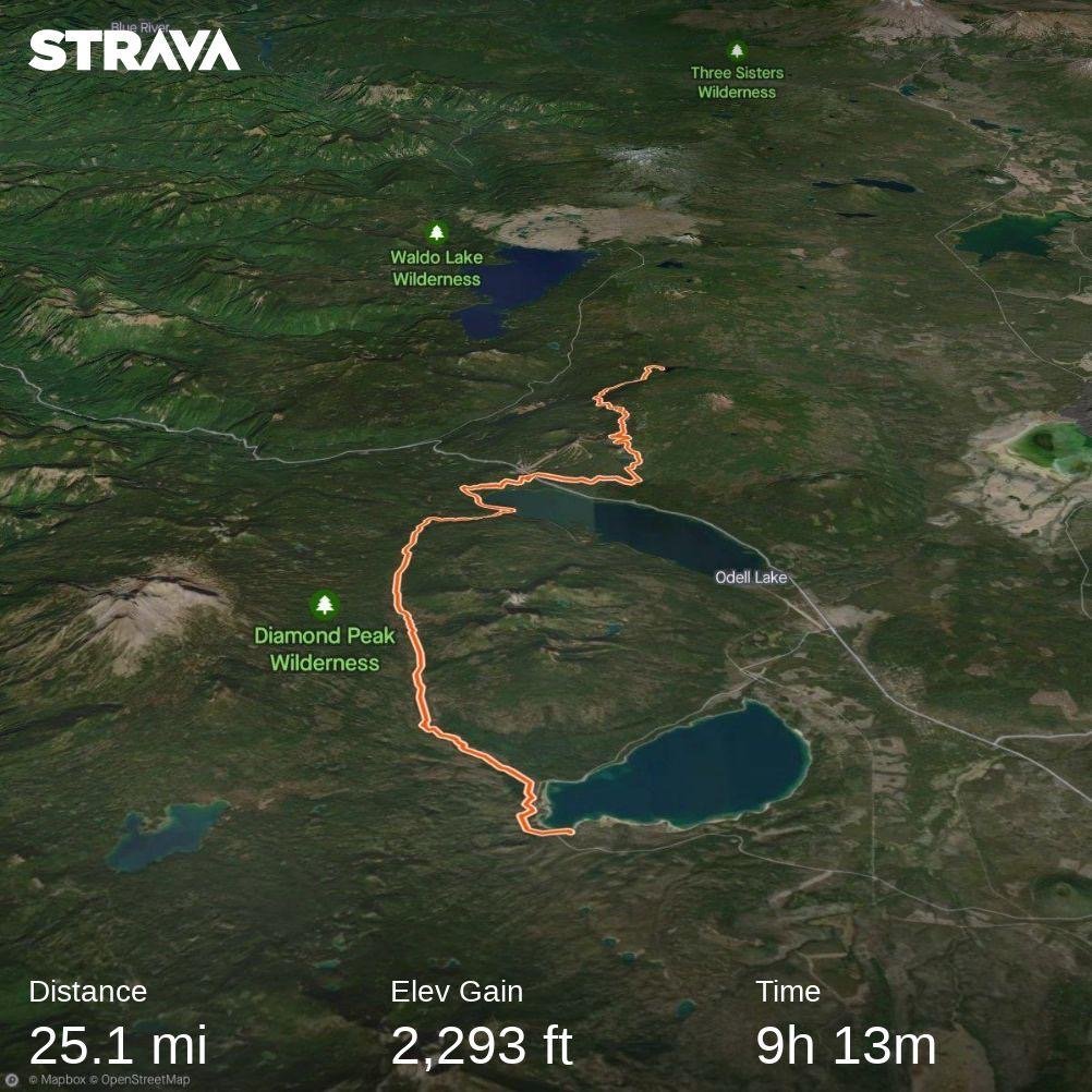
Section: Milepost 1561.4 to 1537.8

Total Trail Miles: 1402 / 2650

Distance: 23.65 Miles

Moving Time: 09:00

Elevation Gain: 2631 ft

Click here for current location

Wow. Last night was a roller coaster. Before midnight a big ‘ol thunderstorm moved in overhead and dumped on us for about an hour. Lightning came down very close and Amanda, hating T&L storms as she does, was not stoked on the light show. Eventually, the storm passed and we passed back out until about 2 am when a diesel truck rolled through camp. Being alone in the campground and it being a weekday, the sudden arrival of the truck was a little alarming. The truck moved to the back of the campground. Generators were started and light bars were erected that lit the forest up like the sun. About 4 guys yelled at each other and laughed - a strong contrast to the dark, quiet forest we were inhabiting just 30 minutes before. I got up to take a look and then came back into the tent. “Not really sure what they are doing, maybe maintenance on the bathroom? Maybe they do it on night shift to not take it out of service?” We sat in silence for another 30 minutes until it was apparent that they were doing their own thing and then passed back out.

In the morning we woke and I was devastated to find that we had left the stove out on the picnic table - with the grid facing up so it had collected a good amount of water. The lighters were also waterlogged. I ran to the restroom and found one of the sites had been set-up with tents and canopies. It appeared as though more vehicles had arrived in the night and set up. Just a large family gathering midweek I guess. At the bathroom, I ran into the NOBO who had stayed up above for the evening. “That was quite a storm!” he said to me. I agreed and asked if, on his way back, he could drop by our campsite and try his presumably dry lighter on our stove to see if it would start. He agreed and I went off to use the restroom.

Coming back, I found that Amanda had had no luck starting the stove. “Guess we will give it the day to dry out?” I said with a shrug. Neither of us discussed the potential that it might be completely dead and would not restart. That would mean cold meals for a little while. After our cold breakfast and NO TEA, we did our typical morning exercises and got underway. The time was 08:15 - bit of a late start given the poor sleep and lack of hot breaky.

The stage today consistently climbs throughout the entire stretch with a few local descents and parallels the northern border of the Trinity Alps wilderness for the first 18 miles. It starts by winding up from the Scott Mountain pass and crossing south under Scott Mountain. The trail traverses high on ridges passing near Kangaroo Lake at mile 9.77 and under Carey Peak at mile 11.2. Shortly after Carey Peak the trail continues eastward along the ridge providing great views down on Bull Lake and crossing Chilcoot Creek at mile 14.33. At mile 16, the PCT makes a huge and annoying u-turn, traversing the inside of the High Camp Creek drainage. One can literally see the trail across a shallow basin about a mile away. After the big u-turn the trail makes a climb out of a saddle with the Parks Creek trailhead nestled in it at 20.5 miles to a set of gorgeous lakes, Upper and Lower Deadfall lake, which mark the end of today’s stage.

We crossed highway 3 and began our steady ascent towards the lower flanks of Scott Mountain. California was in the midst of some hard core fire prevention work near highway 3. We noted this strategy throughout Oregon and Washington. Roads, being good fire barriers, are further improved by nearly clear cutting 50 yard wide sections parallel to them. A few trees are left but always with good spacing. This way, a fire can be stalled and, hopefully, stopped at a road that has been improved in this way. The lower banks of Scott Mountain, near the pass, were evidence of this as we passed through almost entirely clear cut sections of forest.

The trail was very cruise-able, if incessantly upwards and we made pretty good time which helped compensate for our late start. Eventually we gained the first ridge and hiked along flat ground for about 6 miles. The day was in the high 80’s and pretty humid making the climb an effort. At mile 8, we started our second climb up onto the ridge proper and continued traversing northeast.

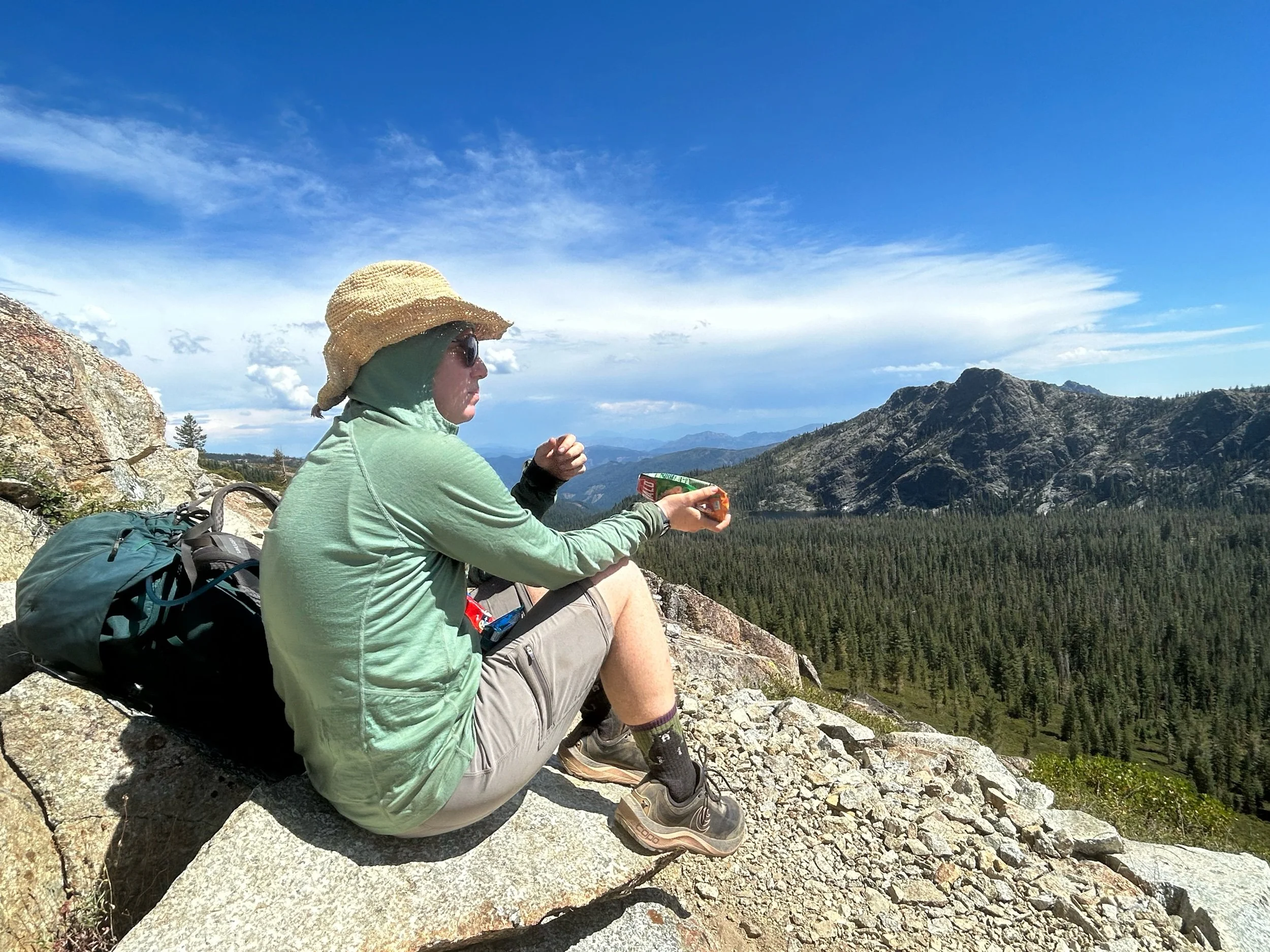
The views from the ridge were amazing. The smoke had abated enough that we could see out on the mountains around us providing gorgeous views into the Trinity Alps. We cruised along, dipping in and out of drainages to maintain the topo lines between miles 14 and 16. At mile 16 we looked across a large, shallow basin and could pick the trail out on the other side. “Okay, this is a little excessive, '' I said to Amanda. The issue here is that the PCT avoids 1000 feet of extra climbing in the stage…by adding an extra 4 miles to the day, a tradeoff that just isn't worth it. We considered bushwhacking across but, in the end, figured we wouldn't save all that much time, so continued on with the exercise. At the Parks Creek trailhead we stopped and used the restroom before finishing up the 4 miles to Deadfall Lakes.

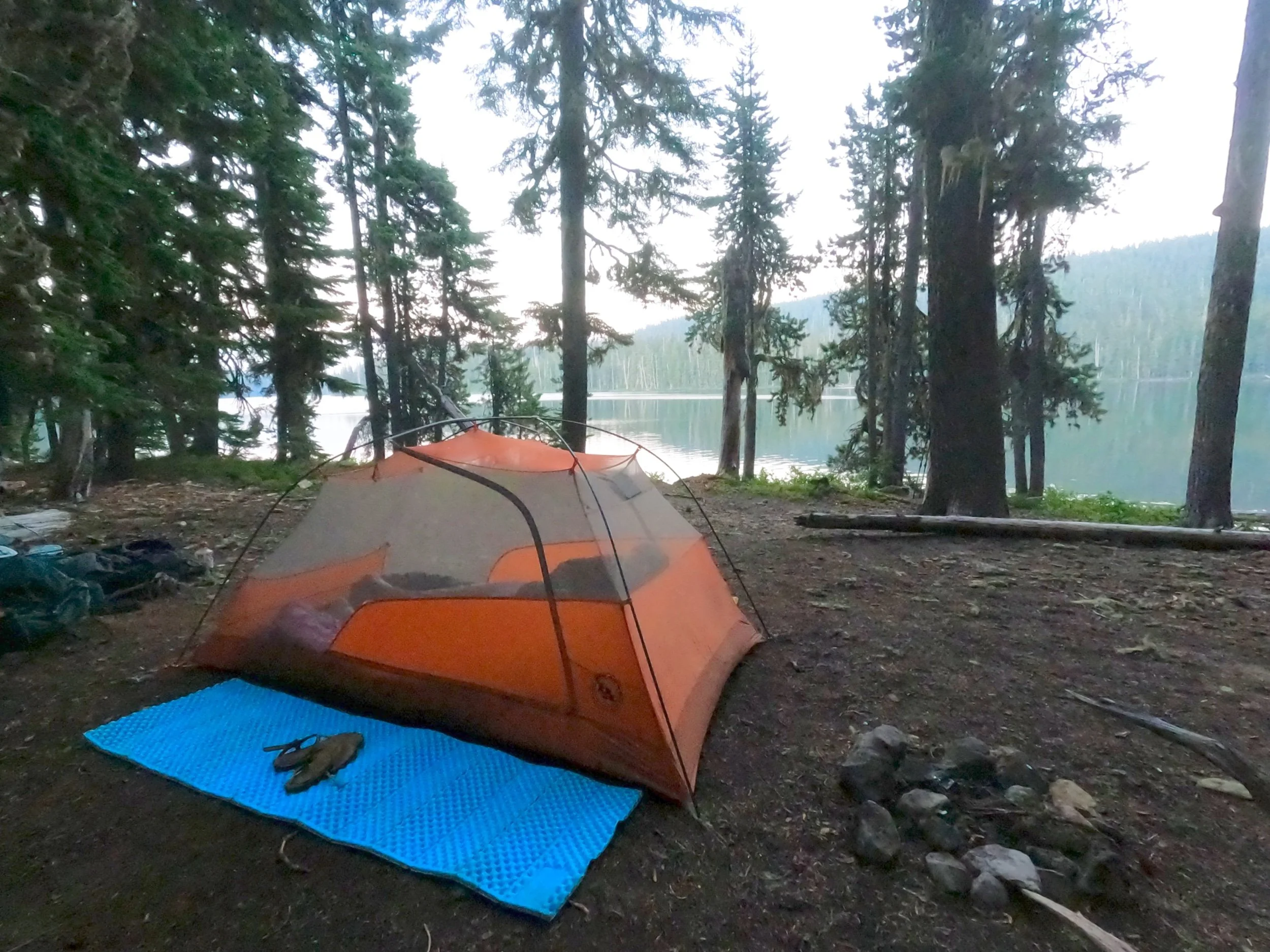
At this beautiful chain of lakes we spent a little time finding a campsite. The sky looked threatening and, for some reason, we both vaguely remembered you were not supposed to camp by water when expecting lightning, but neither of us could work out the logic there so, in the end, we did. We picked a beautiful spot right on the shore and set things up. The lakes were popular for the weekend hikers and about 5 other groups were set up around the lake. We made dinner and enjoyed the nice views. We had arrived just before dark so the light was still good. I took a cold dip in the lake, letting the briskness revitalize my muscles and then did some yoga before heading inside to write-up some notes and pass out.

Day 93: Trinity Alps

Day 93: Trinity Alps

8/17/2023

Section: Milepost 1586.3 to 1561.4

Total Trail Miles: 1378 / 2650

Distance: 25.38 Miles

Moving Time: 10:29

Elevation Gain: 3317 ft

Click here for current location

We woke the next morning to the continued clinking of cow bells. It was a cute sound for sure but it had kept us up last night, constantly fearing a 1200 pound animal was going to come barreling through our campsite. I don’t think cows have the best night vision. We ate breakfast, had some tea and were underway at 06:48.

The path today is kinda frustrating because, for the last 3rd, our heading is literally north…when we should be going south. The route follows a shallow “U” shape through the Klamath National Forest, starting with a traverse around the southern side of an east-west running ridge before dropping down to the Carters Meadow Summit on the Callahan-Cecilville Road where the Trinity Alps wilderness is entered. From there, the trail zigs and zags high above some drainages in an easterly direction, eventually passing under Eagle Peak, at which point the trail turns northeast. At about 16 miles in, the path breaks through the tree line and offers beautiful views of the Trinity Alps wilderness, before descending east off the nose of a ridge to the Mosquito Creek NFS campground. The path then parallels a NFS road for the last 5 miles winding up then down to the Scott Mountain Campground on Highway 3.

Today was pretty uneventful. As we were making our last preparations to leave, we encountered our first NOBO of the day. He asked us which way we were going and we told him south. “That is good. I think this is better.” he said in a strong European accent. It was heartening to see NOBO’s coming through this section, as we looked south to the Deep/Upper Fire.

We eventually bottomed out around mile 6, at Carters Meadow Summit and started climbing again. 5 solid miles of climbing brought us up and out of the saddle and onto the ridgeline. Signs of past and present fire surrounded us. We encountered an older group of weekend hikers along the way with their dogs and talked to them for a while. They are always interested in our progress and story. They said a car at the summit had been broken into and some beer had been stolen, which was a bummer. Once back up on the ridge we looked out onto…smoke. Kinda sad, because we had heard that the Trinity Alps were beautiful but, this is August in northern California these days. Without grand views out, we focused on our feet and saw 3 little frogs along the way. Sometimes you just have to appreciate the little things.

At mile 16 we started our descent. We had started hopscotching with a younger guy who was also headed south. 4 miles on we bottomed out again and started the short and final climb of the day. At the top, we ran into our fellow NOBO again. He was contemplating the path ahead. As we passed we asked where he was thinking of camping for the night. “I’m not sure, I was thinking about going down to Scott Mountain but I heard a group got smoked out there a few nights ago,” he said before taking a heavy drag on his cigarette. Amanda and I shared a grin at the hypocrisy of that comment and then said we were going to give it a shot before wishing him luck and continuing on. Again, we didn’t know it at the time, but the group he was referencing was our fellow, nameless thru-hiker who had bailed at Scott Mountain to retreat to Etna and jumped down to Dunsmuir because of smoke in the middle of the night.

Four more painful miles of downhill brought us to Scott Mountain campground where a bathroom was located in the middle of about 10 sprawling campsites. We picked a nice one close to the entrance and got set up, relishing the presence of a picnic table to keep our things off the ground. After our typical activities and some nice ramen with shredded beef we passed out under a darkening sky.

Day 92: Dodging Fire

Day 92: Dodging Fire

8/16/2023

Section: Milepost 1600.8 to 1586.3

Total Trail Miles: 1353/2650

Distance: 14.1 Miles

Moving Time: 06:03

Elevation Gain: 3307 ft

Click here for current location

Day 92 was an interesting one – this was the first day we really had to think about fire. Throughout Oregon there were fires in the distance but Etna was where we had to start making decisions.

We woke in the morning and headed to the Etna Bakery, which was a wonderfully lit and decorated place serving some excellent pastries. As we headed over I texted Dusty to let her know we were going to breakfast and would be ready around 10 am. I had to return a platypus style filter I had purchased at the outfitters the day before and they did not open until after 8 am. We ordered drinks and some breakfast sandwiches at the café and did some blogging/’gramming. The place was bumpin’ for a midweek morning. While we sat there, a lady walked in and introduced herself as a forestry representative for the Marble Mountain Wilderness. She asked if we were hikers and we said yes and she said “I have some bad news, unfortunately the trail is closed at Etna summit northbound due to fire activity.” “Ah,” we said “we are SOBO’s, any info on the trail south?” She replied that she thought it was still open and then said if we gave her our phone number she would make a call to the Trinity Alps folks to find out for us. We thanked her and went back to our breakfast. “Well, that became an issue fast…” I said to Amanda. “Yea, a lot of lightning last night,” she replied. We still had an hour or so before the store opened so I brought up the fire filter on my Gaia App. A really handy tool, Gaia interfaces with Nasa’s fire scanning raster files to overlay active fires in a given area. Looking at it, I told Amanda “I don’t see anything near the trail southbound, there is a fire about 20 miles south of the trail near the Trinity Reservoir – I really hope they aren’t going to close the trail for that.” I checked my messages for something back from Dusty – nothing. “Think I should start reaching out to other rides?” I asked Amanda. “Yea, we wanna get a move on before they close much more.” I shot off some texts to a few other trail angels and went across the street to return the Platypus filter. As I headed over I received a text back from Robin saying she could come get us in about 30 minutes. I wrote her back saying that would be great. After the return, we walked back to the Inn and got our backpacks. On the way back Dusty got back to me asking where she should pick us up. I let her know that we had organized another ride which she took…less than eloquently. There were a flurry of text messages saying there was no need to go with another trail angel and that she could get us back up to the road which made for a few awkward texts over the next 30 minutes but, eventually, she relented. On our way back to the pick-up spot, in front of the outfitters, we ran into several groups of hikers, including the German couple, who told us they were skipping down to Dunsmuir/Mt. Ashland due to the fires and that we should consider that.

Much, much farther down the trail we would find out what happened that made so many people skip the Etna to Ashland section on this day. A hiker, who I won't name here, but whom we had run into a few times in Oregon had, the night before, gotten down to highway 3 which was about 2 days south for us and made camp there with a few other people. In the night, they had woken up and smelled smoke. Worried that a fire might be moving in on them, they had packed up and hitched back to Etna in the early hours of the morning. Once there, they told their story to many other SOBO’s who seemed to have interpreted it as though a fire had actually moved onto the southern section of the trail and that it now needed to be bypassed. This was false and anyone with a fire overlay could see that there were no active fires around the trail SOBO or simply have made a call to Trinity Alps to see if they were closing the southern section. Amanda and I deliberated, wondering if we should make the jump down as well. I texted the Marble Mountain Forestry Service lady who promptly replied that Trinity Alps was not closing any sections of the PCT south of Etna. “Can’t get much more direct than that,” I said. Our ride showed up and Robin repeated the same schtick about the PCT being closed. I let her know that I had just heard from Trinity Alps that there were no closures. She looked unsure but just said “if that’s what you heard, I will take you up there.”

The ride with Robin was fascinating. Got some hardcore MAGA vibes but she was interesting to talk with. One of our favorite quotes from a woman who said she “hated living in Corvallis” when I asked her about her 541 area code was, “Small town, small minds” in direct contradiction of her seemingly “small town America values.” In any case, she got us up to the pass without incident. The day was starting to look pretty Armageddon-ish with all the spot fires that had sprung up overnight. We got out at the pass as a NOBO was coming out of the woods. We said hi and Robin immediately informed him that the trail NOBO was closed in a way that was less than gentle and made him visibly bristle. He asked if he could get a ride down and she said yes while we walked across the road and started our warm-ups.

Given the late start today, we had planned to go a short distance, just past the southern flanks of Russian Peak. This would allow us to exit out on the Callahan-Cecilville Road if the fire situation got ugly. The route for today climbs out of Etna Summit and gains the upper flanks of a southeast running ridge, passing above the Smith, Taylor and Paynes Lakes while crossing into the Russian Wilderness. Towards the end of the day the path passes back out of the Russian Wilderness and turns east and then south before crossing under Russian Peak and switching down onto a cattle road where a spring makes for a nice place to make camp.

After our warm-ups we started our watches and made our way up the trail, which climbed out of the summit saddle. We walked for some time before running into a NOBO heading towards the summit. “Hey, you guys know the trail is closed this way right?” without a hello or anything. We informed him that we had talked directly with a forestry service representative who contradicted that information and that, to our recent knowledge, Trinity Alps was open. “Well, there was a group that had to bail out just this morning!” a bit self-importantly. We told him that may be but the closest fire was the Upper (later called Deep) fire, 20 miles off the trail and with a whole lot of ridges and roads between it and the PCT – to which he responded, and I will always remember this, “Ok, well, be careful I would hate to see you guys get into a bad situation” with zero actual care in his voice. Northern California was where we started running into some really frustrating characters. The real problem here, I think, was that this guy was very aware that he was going to have to flip up and maybe he had made it through the entire Sierra without having to do that and was loath to do it now. Misery loves company so, for him, if he was getting derailed, then everyone should have to. This is, unfortunately, a sentiment we ran into a few times on the trail – if I have to flip, everyone should have to flip, a sentiment that usually masqueraded as a concern for others safety. So that was irritating but we continued on and soon ran into a forestry maintenance crew strung out along the trail. We said thank you to each of them because no one appreciates clear trails as much as PCT hikers. When we reached the foreman we said hi to each other and then peppered her with questions about trail maintenance. How do you decide which sections to do? Do you think chainsaws should be allowed during really bad years to help get the trails cleared sooner? Do you work with the California Conservation Corps? It looked like you were using pack mules, where you? She smiled and answered all of our questions in turn and in detail and when we were done we said thank you again and carried on up the trail.

Another couple hours brought us out of the Russian Wilderness boundary and dropped us onto the south side of an east-west running ridge. We hiked on and ran into two older ladies hiking NOBO. They were doing the Northern California section and had left their car in Siead. Evidently, a large fire had sprung up east of Siede and was moving west. One of the women added, wryly, “I hope I still have a car when we get there, if we can even get there.” We all laughed about that and then went our separate ways. The sky opened up and we briefly put on rain jackets. Amanda asked if we should modify our end point due to the thunder and lightning that was around. I looked at the map and found that we were going to be in the trees and so said we could continue on to our original destination. We hiked for another 2 hours, passed under Russian Peak and wove our way down some switchbacks to the old road grade that was going to serve as our tent pad that evening. In the distance, we could see the mushroom cloud forming above the Upper fire near Trinity Lake. “That does look concerning,” Amanda said. “Yea,” I agreed “but they always look worse and closer than they are. This one would have to hop a lot of roads and ridgelines to get to us.”

We reached the road and set up camp. Amanda got the tent going, being wary of the many ant hills that permeated the road while I tramped down to the bee infested spring to get some water going. I had really hoped we were going to get a new filter in Etna, but alas, it was not to be. I collected some water out of a cleverly devised “leaf” spigot that someone had left and returned to the tent. A belly drop plane flew overhead toward the fire, which was worrisome. Amanda had things set up and I sat down on the mat to boil water while listening to the clinking of cow bells below us. “I really hope they don’t use this road in the night to come up to water,” I half joked. “That would be quite the wake up,” Amanda agreed. After dinner we passed out – this time before dark.

Day 91: ETNA!

Day 91: ETNA!

8/15/2023

Section: Milepost 1614.8 to 1600.8

Total Trail Miles: 1339/2650

Distance: 14.13 Miles

Moving Time: 05:56

Elevation Gain: 1762 ft

Click here for current location

Last night the light show really went off. For about 2 hours we were surrounded by lightning so, maybe, not the best sleep ever but really cool to witness. Amanda is not a fan of thunder and lightning, especially when she’s separated from it by only a few millimeters of fabric. I missed saying hi to Cat and Mouse as they were up and out super early. We ate and took a little longer to get ready and were last out, behind the German Couple by a few minutes.

Today’s stage exits out of the Marble Mountain Wilderness to Etna. The stage rounds around a few local peaks and cuts across Shelly Meadows before turning due south and then east. The path exits the Marble Mountain Wilderness about 2 miles before reaching Etna Summit on Sawyer’s Bar Road.

After some tea and breakfast bars we were out at 06:45, chasing the Deutchen. The day was pretty uneventful – a lot of weaving around local peaks and staying towards the top of ridges whenever possible, I mean – it is called the Pacific Crest Trail for a reason. It was hot again today, hence the thunderstorm, but fortunately we were higher than our ascent out of Siead so that was a relief. We ran into a few NOBO’s hiking out of Etna. One encouraged us to take a look at the little spa in town as well as the outfitters. He also said that we should take any chance we get at cell service to call a ride up from down below as there wasn’t too much between where we were and the road.

We continued south and, at the turn east, we caught some service. There was a…disagreement…at the turn about stopping and making a call or continuing on. We ended up stopping and making a few calls down to Etna. On the 3rd try we got a hold of a trail angel named “Dusty” who was happy to give us a ride. The call cut out towards the end but enough critical information had been transferred at that moment that we could be reasonably confident she would be at the summit for us when we got there about an hour and twenty minutes later.

The path turned downwards as we sank to the road. We picked our way down, occasionally skating on round rocks that made their way under our feet. Again, walking in the Marbles is really like walking on marbles. A little over an hour brought us to the road and a Ford Escape sat waiting on the far side of the road. Dusty recognized us, flipped a u-turn and came up to us asking if we were Amanda and Payden. We said yes, got in and Dusty pulled out onto the road headed down to Etna. As we descended several thousand feet, Dusty told us all about Etna and when we arrived in town she took us on a little tour so we knew where everything was. Sadly, it was an early weekday and both the new brewery and distillery were closed, but Dusty did point out Dotty’s, a nice diner style hamburger joint which served burgers made of locally sourced beef and supposedly amazing homemade drinks. Dusty also pointed out a few venues for the evening as well as the city park which was targeted towards accommodating budget minded hikers. After a swing through town, Dusty dropped us at Dotty’s and we paid her 20 bucks for the ride before getting out. We went in and ordered two burgers and Amanda got a Root Beer malt while I went with a homemade Lime Ricky. Oh..My…God – those alone were ludicrously good. The drinks were served in like 100 oz mugs with that good-good crushed ice but I still put most of mine down before the burger even got to me. The burgers were great, they ranked in at a solid 2nd or 3rd place on the trail so far with some tasty fries. I polished off Amanda’s malt because it was insanely good as well.

Once we were done, Amanda and I made the very hot walk back to downtown while deliberating on a place to stay for the evening. We decided on the Collier Inn, which was in an old common house that had been masterfully redone in the style of the day and sat just outside of downtown. We went in and called the number on the informational board. A lady picked up and said she was headed our way. I headed to the Ray’s grocery store across the street for some beverages and snacks while Amanda got us checked in. When I came back we both took showers and then made a list of things we needed.

We split up and I headed to Etna Creek Outfitters while she took a walk through downtown. The outfitter was one of the best equipped and well organized little shops we saw on the trail. Run by a young woman and her mother, they had everything we needed, including trade in’s for DarnTough socks which we took full advantage of. Happy to say I got some awesome American Flag patterned socks! I also looked for a replacement filter for our ailing Sawyer, but they had been crushed by hikers in the past weeks and were completely out. As I was shopping, a deluge came down outside making it impossible to hear anything in the store… kinda glad we weren’t in the park under our compromised tent. Thunder boomed everywhere. Hopefully the water was dampening any fire activity down… I checked out and walked across the street to where Amanda had just made an appointment for the spa. I had wanted to spend the evening writing but she said I was coming with so… evening got filled up for me. Our last stop was at the Ray’s where we found a decent resupply for ourselves. The walk back to the Inn smelled strongly of fresh rain quickly evaporating off the hot pavement. We spotted the German couple and asked if they wanted a beer and they followed us to the Collier. We chilled in the common room talking about our time on the trail and living in Germany. Eventually they continued on, wanting to catch Dotty’s before it closed and Amanda and I headed to the Spa.

I’ll be the first to say, the Etna Spa was fantastic. A kind old lady met us in front and we picked out our own salts before heading out to a back patio where two soaking tubs waited for us. We stripped down, mixed in our salt and got in, enjoying the mix of scents from the warm California evening and our salt. We soaked for a solid hour, broken up by a very quick stint in the sauna and, around dark, begrudgingly got out to head back to the Collier Inn. When we got back, I made some homemade nachos with Tillamook cheddar cheese, ground beef and the other typical fixins’ – it was fantastic. Afterwards, we quickly passed out. Etna, at this point on the trail, is probably one of our favorite little towns. It has everything hikers could want and the brewery and distillery weren’t even open! We both agreed as we laid in bed that someday we would do a PCT road trip and Etna would definitely be on the list of stops.

Day 90: Halfway There!

Day 90: Halfway There!

8/14/2023

Section: Milepost 1635.6 to 1614.8

Total Trail Miles: 1325/2650

Distance: 20.67 Miles

Moving Time: 09:06

Elevation Gain: 3724 ft

Click here for current location

Well, we slept moderately well last night. The “Weird California Deer” kept the forest sounding very alive most of the night, but we were almost too tired to care. Today, our objective was to get as close to the pass above Etna, CA as possible and leave as little mileage as possible for us the following day. Along the way, we crossed the 1325 mile marker, putting us at our own, personal halfway point of the PCT.

The stage we followed today climbs a bit out of Buckhorn spring, staying high on Big Ridge while making its way south-southeast. We are in the Marble Mountain wilderness and it is a gorgeous area of northern California. At the end of Big Ridge, the trail gains and descends from a number of small saddles, mostly above tree-line, before progressing through a series of alpine lakes and passing directly under the Marble Mountain. The trail passes through one final pass, transitioning to the northeast side of a ridge and finishing on the banks of a small alpine lake. The original intent today was to get to Shelly Meadows, however, we found that it may be called the Marble Wilderness, not due to the mountain so much as that it feels like you are walking on marbles the entire time you hike here, and that sucks - so we cut it a little short today.

I don’t have much for today, it was pretty innocuous. We hopscotched with a German couple from the Black Forest area and most of our interactions with them were high fidelity flashbacks of the last two years of our life living in Germany - i’ll just leave it at that. The temperature was definitely cooler today. Not by much but enough to be appreciated. Anything south of triple digits is something to cherish I suppose. Way out south, we could see something snow covered. Whether it was the Sierra or just some high sections of the Cascades was difficult to discern.

Towards the end of the day climbed through a number of small saddles and gained the tree line, getting fantastic views west and east at the Marble Mountain wilderness. We crossed under Kings Castle mountain and took a rest at Paradise Lake. Walking on the rock strewn ground most of the day had spent us and Amanda asked the tell-tale question “how much further?” “5 miles” I answered “how are you doing?” “Think I am done, can we stop here?” As we usually do in these situations I proposed a compromise. “There are some nice lakes about 2 miles out with campsites, can you make it there?” I asked. “If I have to,” she replied riley. We carried on. The Marble mountains were truly gorgeous. We passed the German couple refilling water at Big Rock Fork, just under Black Marble Mountain and traversed across Black Marble Valley. We crossed over another saddle above the tree-line and descended the other side, storm clouds threatening in the distance. Another mile brought us along a ridge at 6400 feet where two small lakes sat nestled under some bare peaks. At the second one we stopped and made camp. The Bellingham couple was already in their tent so…missed that Bellingham connection again. We took a spot about 20 feet away and left a third, if non-optimal, spot for the Germans who showed up about 20 minutes after us.

I filled water while Amanda set-up the tent. It was a bit tight but with rain threatening we put up the rain fly. After dinner we cleaned up and went to bed, ready for the light show we were almost certainly going to get that evening.

Day 89: Sittin’ on a Scorpion

Day 89: Sittin’ on a Scorpion

8/13/2023

Section: Milepost 1657.5 to 1635.6

Total Trail Miles: 1304

Distance: 22.64 Miles

Moving Time: 09:32

Elevation Gain: 5676 ft

Click here for current location

The next morning we woke and got out pretty quick, wanting to get to the café by the time they were open. This was another one of those mornings where Amanda would tell me I was being “unnecessarily pushy” to get a move on and, in this rare case, it did truly turn out to be unnecessary. We folded up the tent and put our air pads away before packing it all into our packs. By the time we were ready to go, most of the rest of the camp was already headed north. I added our name to the guest book and did a quick peruse of the other hikers and, indeed, the group I was snooping on last night was Cat and Mouse from Bellingham, Wa. I put our names right below theirs - “Sheets and River Dancer, Bellingham, Wa” after which we departed for the Seiad Cafe.

Twenty minutes of walking back down the main road brought us to the Seiad Cafe and general store. My Aunt Joni had sent her second care package, the one with many of the meals in it, to this general store, so we were excited to get that package and maybe score some pancakes at the cafe. We arrived at the store about 20 minutes before either it or the cafe were supposed to be open. While we waited we talked to the fairly…insufferable hodgepodge of people that congregated at the store with us. There was the UK kid who was already not our favorite person for the dinner comment the night before, then there were two guys that had been sudo hiking with Markus. One guy kept going on about how he lived this vagabond, dirtbag lifestyle but also had a wife and several adult children at home so… yea, seemed like a solid mid-life crisis in the flesh. The other guy, from the UK, seemed okay but just generally avoided talking or saying anything more than necessary.

At 8 am, a beat-up Windstar van showed up and a woman got out and began opening the store for us. We went inside after her to look around and when she was settled asked after our package which she quickly found for us. We took it outside and our little cohort of misfits, being the “elite” thru-hikers that they were all made comments about how heavy it was. We shrugged it off with a comment about making a nice donation to the hiker box. Probably should have avoided saying that because UK kid decided it was an invitation to hover over us while we unpacked it. I’ve been married to Amanda for 8 years and known her for 14 now. She’s the most gentle person i’ve ever met but in that moment she was giving off really strong “i’m about to punch this kid in the face vibes.” Fortunately she controlled what was probably a strong urge to do physical harm and we turned out a few items into the hiker box which were promptly scrounged up. At this point, the lady saw us looking over at the cafe and said “the family that runs the store has a few young kids that they have been taking down to the county fair each night and coming back late - they probably won’t be in today despite what the hours say.” We thanked her and looked at each other. Seiad valley was quickly becoming one of our least favorite places on the trail. The hiker family showed up in their dilapidated van and Amanda and I started to shoulder our backpacks to get out but, just then, one of our favorite people on-trail showed up. I turned to Amanda “I think that’s Niccolo,” pointing to a figure about a block away coming up the road. As he came up i let out a “Holy Shit - Niccolo!!?” He smiled and gave me a hug as a few others hiking with him showed up just behind. They went into the store, also dismayed that the cafe was closed, and came out with pints of ice cream which they promptly started tucking into. We sat near the street while Niccolo recounted his time in the Sierra and what had happened to the others we had been hiking alongside with around Julien while Queen Bee hovered nearby. Eventually, we said goodbye to Nicollo and wished him luck on his 40-a-day sprint to the Canadian border and got the hell out of Seiad. The time was 9 am and it was already in the upper 80’s - today was going to be hot.

We walked the road, which was the PCT, across the Seiad river and turned to walk alongside it for 9 brutal miles. At one point, as we made our way along, a group of NOBO’s stopped and pushed peaches into our hands. Along the road were several orchards with hiker-friendly owners who like to make offerings to the hikers during the season. We reached the end of the road at a campground that demarks the transition back to dirt trail and stopped to snack. My favorite snack on this trail is quickly becoming potato chips - specifically, Kettle Brand chips. I don’t really have a specific flavor, they’re all good, but Kettle is the clear winner followed by Tim’s. They are salty and delicious. I make small slits in the roof of the bag and deflate them so they pack well and generally go through a normal sized bag a day.

At the campground, we relaxed for a while before crossing the stream and heading up the trail. The day was hot - like triple digit hot - and straight-up oppressive. The trail made its way along the Seiad river, climbing steadily upwards as it made its long march out of Seiad. We crossed into a burn zone and things started to get really ugly. Without shade and in the full force of the sun I started to feel nauseous, even at the snail's pace we were going. Finally, we made a stop at a shaded water stream and pulled our shoes off to enjoy the cool spring water flowing by. A girl we had been hopscotching with since the campground went by and said “Solid idea taking a break here - I wish I had waited for this spot,” before continuing on. We sat for a while and I got up to set the Sawyer to gravity filter. As I made my way to the backpacks, Amanda looked down at where I had been sitting. “Hey Payden,” she said incredulously, “did you know you were sitting on a scorpion?” “No way!” I said quickly returning to where I was sitting but as I looked down, sure enough, there was a medium, brown scorpion in the space I had just vacated a second before. Now exposed, the brown insect was attempting to get back into some cover while Amanda and I were scrambling to take a picture of it on Amanda’s nature identification app. The scorpion was faster though and soon had itself tucked into a log where we couldn’t get to it. “That was crazy!” I said smiling to Amanda.

Eventually, we left the refuge of shade and returned to the oven of pain. Fortunately, the burn section ended and we were soon back into the trees where things were a solid 10 degrees cooler. At the end of the burn section, the trail started to climb steeply, switching its way out of the river valley and up onto a ridgeline. We climbed and climbed for what seemed like hours, passing a good spot with a few other campers already setting up. On the way up I saw a pretty yellow breasted wren and ran into a few groups of deer that refused to yield the trail to us. The sun set and we carried on, observing more scorpions and some chubby bullfrogs as we switchbacked ever higher.

Just when we thought the climbing would never end, the trail dumped out into a clearing signifying our arrival to Buckhorn Spring, our camp for the night. Already at the clearing were several tents and about 20 sets of red eyes glaring back into the shine of our headlamps, greedy for salt. “These California deer are super weird,” Amanda muttered as we struggled to find a campsite without lighting the neighbors up with our beams. Eventually we did and I ran to get water while Amanda set the tent up and set up for dinner. It was 10 o’clock and so much of our nightly regiment went out the window. We were fed and in bed in about 30 minutes, happy to be out of Seiad and through the worst of the heat.

Day 88: More Old Friends

8/12/2023

Section: Milepost 1684.3 to 1657.5

Total Trail Miles: 1282 / 2650

Distance: 23.19 Miles

Moving Time: 08:56

Elevation Gain: 1220 ft

Click here for current location

Ah, today was the great descent to one of our least favorite spots along the Pacific Crest Trail - Seiad Valley. The first half today’s path traverses near the top of a ridge system above 6000 feet through some small burn sections before making a brutal, 4000 foot descent into Seiad valley itself.

We woke in the morning and both laughed about our sad attempt to stay up and catch the meteor shower. My GoPro’s attempt wasn't much better… We ate some fancy fig bars and drank some tea before embarking around 7 am. As we walked, we talked about a book Amanda was reading (well, listening because it is difficult to walk and read at the same time) called “Thirst.” It’s the story of a Bellingham woman who set the unsupported speed record on the PCT a few years ago. At around 8 am we ran into UK Sam and stopped to talk with him. Again, this was our first meeting since Whitney and we were excited to catch-up with him. His backpack waist strap had broken a day or so before but he was persevering, if not easily. The good news was that Osprey was replacing the backpack wholesale for him…once he got to Ashland. He told us about the descent into Seiad - it was a mess. The Manzanita bushes had grown wild over the summer and taken the trail back such that whole sections of the descent involved bushwhacking and navigation. Supposedly, the trail was gone and extremely difficult to get through and many people were opting to take road 48N20 down from or up to the saddle. We thanked him for the info, said our goodbyes and continued on. One hour along we ran into none other than Markus and sat down beside the trail to catch up with him. He reiterated the same thing UK Sam had said about the trail conditions and regaled us with all that had gone on with him since we had split up, including what sounded like an epic SKI-ERO day in Mammoth in July. It also sounded like most of the group was going to head to PCT Days in Portland and he asked if we were going as well. We said no and that we couldn’t justify losing 3-4 days to go back to Portland. We talked a little longer and then split up, heading our separate ways and wishing each other good luck.

Another hour or so brought us along a ridge and down a slow descent through burn zones to a saddle where we stopped to gravity filter water and eat lunch. During lunch we weighed our options for getting down. It was 95 degrees and still heating up. Hacking through 9 miles of manzanitas on a non-existent trail seemed like a one-way ticket to suck-fest so we decided to forgo the trail and hit the road.

We finished lunch and started down the trail, the mercury inching ever higher. The road was far from fascinating. We meandered further and further into the Seiad River canyon. At one point, a group pulled alongside us in a Toyota pick-up and asked if they could offer us a ride down. We politely turned them down saying we wanted to walk it all. After they left Amanda looked sideways and said wryly “I would have taken that ride.” “Yea - me too,” I said back. Hours moved by at a snail's place as our knees began to protest the not-too-terrible but relentless march down. A few sharp switchbacks brought us alongside the river and we stopped to pick some late season blackberries along the road. We hiked on and eventually started to notice houses and cabins built up along the river. Suddenly Amanda stopped, clutching her nose. “Bloody nose,” she said, rolling her eyes. We stopped to let it re-clot and as we waited a random man pulled up in a Prius, jumped out and in an Eastern European accent asked - “do you need some tissues?” Bewildered, Amanda smiled and said yes to which he threw open his trunk and pulled out a roll of paper towels and dispensed them to her. With the help of new materials, the nosebleed was stemmed and then, this Romanian angel took the bloody tissues back, wished us luck and drove off. “What was that?” I asked Amanda with a bewildered smile on my face. “So random, but exactly what I needed,” Amanda said looking back at me. We tried to walk but Amanda was still feeling a little light headed, so we sat on the side of the road under a “State of Jefferson” sign eating Fritos until she felt good enough to leave. We hiked down the road, eventually coming into the “center” of Seiad valley just as the light was fading. Once we hit the central intersection, we turned right and hiked up highway 96 about half a mile to a hiker-friendly campground, called Wildwood, where other thru-hikers helped us find a spot and get settled. One kid from the UK, who maybe wasn’t the most socially with it, was kind enough to let us know we had missed a full, complimentary dinner by only 30 minutes. His exact words were something like “if only you had been here 30 minutes earlier - the table was full of food!” I thought Amanda was going to kill him. We got our tent set up and ran a quick load of laundry. In between I kept looking over at the couple next to us in their tent - felt like a creeper, but I kept thinking the guy’s shirt said “Ski-to-Sea” on it, which might have made them the other “Bellinghamsters” we knew were somewhere around us on the trail. By around 9 pm we finally turned in for the night, fighting against the heat still holding on to get some sleep in preparation for the big climb out of Seiad the next day.

Day 87: Oregon Complete!

Day 87: Oregon Complete!

8/11/2023

Section: Milepost 1709.3 to 1684.3

Total Trail Miles: 1255

Distance: 24.17 Miles

Moving Time: 09:02

Elevation Gain: 4052 ft

Click here for current location

Today we completed Oregon and what an amazing milestone to hit! The stage starts off at the same wilderness shelter we had slept at the night before and traverses southwest until it hits the California/Oregon border. From here it descends through forests and cow pastures crossing a labyrinth of forest service roads and eventually arriving at a saddle above a spring where we camped for the night.

We woke around 5 the next morning. The light is starting to fade as we head into fall but it is still almost imperceptible here in August. Chewy got up as we prepared to leave and, in classic thru-hiker fashion, was ready to go in under 20 minutes and leaving north about the same time we departed south. We bid farewell and good luck to him and went our separate ways.

The morning was pretty uneventful. More wooded sections separated by beautiful clearings filled with wildflowers and forest service roads. About an hour in we ran across half of the “German” group we went into Sequoia National Park with a month before. We stopped and talked with them. The group had dwindled to the German guy and French girl as well as the two girls from the midwest. We talked a little bit and then continued on. Not long after that, we stopped to filter water at a nice sheltered area with a spring fed stream running through it. The Sawyer is starting to slow down noticeably. It’s getting so bad that we are starting to dehydrate ourselves to avoid filtering because it is now a 45 minute affair to refill. I attempted to backflush the filter in Ashland but I think if it goes too long before backflushing, the effectiveness of the flush becomes drastically reduced. So, yea, we try to go through the entire day now without filtering so that we can just gravity filter 2 liters apiece overnight and make that work the next day - not optimal.

We spent much of the midday traversing the shoulders of ridges heading south and west. At one point around 2 pm we broke above the treeline briefly and ran into Kirstin from San Diego whom we had started out of Campo with on day one. We stopped and caught up with her for a while. She had been hiking with Travis, the guy who was initially carrying an ultra-light chair in the first stages of the trail, and indicated that he was about a day behind her and that she had finally talked him out of the chair. While talking with her, a bumblebee landed on my shin and I absently brushed it off thinking it was a fly. Well - it didn’t like that, got scared and stung me which made me sad ‘cause the whole situation could have been avoided. So that’s sting number 2 for me on the trail. Before we split going our separate ways, Kirstin excitedly told us that there was trail magic just before the border and that they should still be there. We left ultra energized to get some trail magic in an hour or so.

We hiked on for another 90 minutes, up and over a ridge and descended to find 3 older campers waiting with tables, cold beer and chili. They weren’t the only ones either. As we approached we caught sight of IZZY! We had not seen Izzy since the day we climbed Mt. Whitney and were so excited to catch-up with her. We approached and were motioned to chairs. The trail angels were from Ashland and had come up to trail-angel and see the meteor shower that was expected that evening. I had a Sierra-Nevada Torpedo and some chips with salsa. Amanda talked with Izzy while I chatted with the trail angels. As we talked, Queen Bee showed up alone as well as another hiker, Ranger, from DC who had also straight-lined it through the Sierra. We all chilled and enjoyed some time off of our feet before Amanda, Izzy and I decided to head out. We took a picture with a big PCT sign the trail angels had brought, gave hugs all around and headed our separate ways wishing each other luck.

About 45 minutes on, we hit the California border about the same time Queen Bee, who was slack packing again, caught up to us. We stopped and chatted and she took our picture at the border. She was doing a big day and still had 20 miles to go with sunset only a few hours away. As we were about to leave, the rest of her family came up the trail, NOBO, and she stopped to check-in with them. I’m not really sure of the logistics of what they were doing - some going SOBO and others going NOBO, never really understood how what they were doing worked. In any case we carried on and descended about 700 feet, eventually bottoming out in a cow pasture. We gave the cows a customary “moooo” which was returned with an ambivalent stare before moving on.

From the cow pasture we climbed 1200 feet in about 5 miles, filling water again, where Queen Bee caught up to us. Night was falling and she confided nervously that she hated hiking after dark. We bid her good luck and, after another agonizing 45 minutes of filtering, carried on upwards, eventually pulling ourselves near the top of a ridge. The trail wound around the head of a valley and met up with a forest road where we stopped for the night, dusk already turning the world dark. One other hiker was already set-up and got settled a short distance from him. Amanda pitched the tent while I descended a few hundred feet into the head of a nearby valley to gather water for dinner and gravity filtering. The steady “tinking” of bells could be heard in the distant bringing back memories of our Alta Via hike in the Dolomites 2 years prior. After I had gathered up all the water I could carry, I climbed back up to the saddle and started dinner. Tonight was some Good-To-Go brand freeze dried meals. The freeze dried meal game has come a long way in the last 10 years. My favorite are the Good-To-Go meals out of Maine, specifically the Cubano and Adobe bowls. They are both 1000+ calories and super tasty. We finished up dinner and cleaned up. I did my yoga in the middle of the road, set up my GoPro to record the meteor shower around 1 am and laid down. We had fully expected to stay up and try to catch the beginning of the shower but fell asleep pretty much as soon as our heads hit the air mattress.

Amanda and Payden at the California/Oregon Border!

Day 86: Mount Ashland Ski Resort

8/10/2023

Section: Milepost 1719.7 to 1709.3

Total Trail Miles: 1230 / 2650

Distance: 11.21 Miles

Moving Time: 04:27

Elevation Gain: 2861 ft

Click here for current location

We woke on day 86 in a bed for the first time in over 2 weeks. It was fabulous, though Amanda and I are both finding that our bodies have so adjusted to sleeping in a tent and on an air pad that we honestly don’t sleep that well in hotel rooms anymore. I think there is too much artificial light and road noise. After organizing our stuff we stalked down to the lobby for breakfast. We loaded up on some continental goodness and swiped some peanut butter packets and tea before heading back to the room where we caught up on some digital to-do’s (gotta keep the ‘gram updated on our activities 😂).

By the time we had finished all of our correspondence, the morning had passed by and we decided that, given an already delayed start, we might as well enjoy the endless cuisine options in Ashland. We headed down to the Green Leaf, near where we had had dinner the night before and, after getting a table and ordering, I ran down to the local second hand outdoor store to donate a few things to the hiker box and grab some batteries. By the time I came back, my meal had arrived and we tucked into some more phenomenal Ashland food.

After lunch, we caught another sketchy Uber out of Ashland down I-5 back to the trailhead where we had met the hiking family the day prior. The day was already heating up - a warning of things to come. We did our pre-hike stretches, donned our backpacks, gave each other a fist bump and started up the trail.

The route today heads almost entirely west and up from Siskiyou Summit on I-5 paralleling the Mt. Ashland Ski Resort access road and eventually progressing on the backside of the now very dry slopes. Towards the end of the day, the trail passes through beautiful open slopes in full bloom under the summer sun and ends at a forest service campground and wilderness shelter.

We climbed through forests of moderately sized trees, both sweating profusely despite consistent shade, while cars occasionally passed below us on the Mt. Ashland ski resort road. The trail passed by some nice looking lodges as it made its incessant climb ever upwards. The 5 hours passed by without much incident and we eventually popped out in some beautiful high meadows with small streams cascading through them. About a mile before our scheduled stop at the shelter we filled up our bladders and continued on.

I’m sad to say we blew right past the shelter before realizing it was below us, down the hill, at a campground. We backtracked about a quarter mile before descending to a small campground. We were greeted there by an older group excited to hear about our adventures on the trail and who gave us a bottle of red wine to celebrate. Shortly after we arrived at the shelter and started setting up a NOBO named Chewy (Sean) showed up and set up next to us. In his mid-twenties and from Canada, Chewy had braved the Sierra in a straight line and we compared our pictures of Forester pass. His were definitely more snowy…but far fewer sun cups to contend with. We had dinner together and while eating we discovered that we had both been at Oktoberfest in Munich on the same weekend. Doubtfully we ran into each other but it was still funny and we all agreed that it’s one of the greatest parties in Europe one can go to. Eventually we all said good night to the resident rat in the shelter and turned in for the night.

Day 85: Ashland, OR

8/9/2023

Section: Milepost 1731.1 to 1719.7

Total Trail Miles: 1219.7

Distance: 11.73 Miles  

Moving Time: 04:28

Elevation Gain: 1224 ft

Click here for current location

Today we woke extra early to capitalize on our time in Ashland. Our path on the 11 mile sprint to our NERO day picked up where it had left off in the Soda Mountain wilderness and traversed almost due west towards I-5. Along the way the PCT passes south of Porcupine rock and north of the enticing Pilot Rock before descending a long, steep grade to I-5 at the Siskiyou summit. The stage ends on route 273 (Old Hwy 99) which is traveled northwards for about a mile, under I-5 to where the PCT continues west.

We were up and walking by 6:30, enjoying the cool of the morning. The path, like much of Oregon, was flat and easily traveled and the miles flew by. We were met along the way by epic views of Soda Mountain and Pilot rock not to mention 15 or so NOBO’s telling us stories of how amazing Ashland was. It had been 15 days since our last sleep in a bed and, while we were getting very used to our mesh and fabric sheltered evenings, we were both excited for a shower and some clean sheets. Along the way we also made friends with a Rosy Boa!

We eventually weaved our way down a steep grade, after talking with a group of about 20 boomers, and reached Old Route 99. From here, we worked our way north, under I-5, to where the PCT picked back up heading south. Here we called an Uber and sat down to wait. As we sat there in our reverie, a well-loved van pulled up with a couple and about 5 kids. They jumped out and some of the band started getting their things together to start walking. We talked to them for a little while before realizing that this was the family we had heard about hiking the Pacific Crest Trail this year. The Mom’s name was Queen Bee and the dad’s name was Spreadsheets, a variation of my own name. They were originally from the midwest but had been living in Chad for the last 10 years as doctors associated with, if I understood correctly, a mission in the country. We talked for a little while before the mom and two oldest boys started off slackpacking up the trail. As they explained, this was how they were doing some of Oregon. Slackpacking certain sections with some of the kids and other sections with others.

Eventually, our Uber showed up. He had been heavily delayed because of roadwork on I-5 and apologized profusely. We loaded our things up and got in and he rejoined I-5 traffic headed north. About 35 minutes brought us into downtown, maybe a bit longer because our driver refused to follow the very deliberate directions layed out for him in the Uber app, but whatever - he got us there. At the hotel I had reserved, we got out, thanked him and went in. At the reception desk we discovered that our room was not quite ready and that we would have to wait until later that day to get in. Slightly let down, we walked down the street to get a burger at “Flipped” which we had seen on the way in. We both ordered the special, a Greek burger, which was phenomenal, but it was here that I realized I had made a mistake in directing our resupply package.

A few weeks prior, my Aunt Joni had asked if she could send us a resupply package. Delighted, we had said yes and provided an address to send it to. It was only as I was finishing the last crumbs of a second burger at Flipped, however, that I realized that address was actually all the way back at a lodge near where we had exited the trail earlier that day. Some hikers choose to not go into Ashland at all and instead stay at a lodge near Old Route 99 called Callahan’s Mountain Lodge at Siskiyou summit. Well, it turns out the address for the lodge is what I had provided to my Aunt without considering the fact that we would be going into Ashland and that the better option would have undoubtedly been the local post office. So, after putting down two amazing burgers at “Flipped” we called an Uber, who happened to be the same guy who had picked us up from the trailhead, to take us back down I-5 to Callahan’s Mountain Lodge where we were able to grab the package. While waiting for the kind lady behind the counter to go find our box I was dismayed to see a local tv station calling for a heat wave and triple digit temperatures coming our way the following day. She quickly returned and I was reminded that my aunt had actually sent two boxes, of which this was the first, weighing in at about 22 pounds. We returned to the Uber and once back at the hotel we were allowed in and turned the goods out onto our room’s bed, reveling in all the goodies that would take us south towards the California border.

After everything was organized we headed out into Ashland and got dinner at Brickhouse, an awesome meeting-hall style eatery on mainstreet. I enjoyed some examples of Oregon’s incredible brew scene and Amanda got a custom cocktail while we sat and reflected on our time since Cascade Locks. We were able to recreate each day, with each other’s help, and where we had stayed each night. After dinner we headed over to Ashland’s cinema to catch the Barbie movie which was excellent (not to mention the popcorn that I couldn’t stop eating) before returning to the hotel for some much needed rest.

Day 84: Anniversary Hike

8/8/2023

Section: Milepost 1750.0 to 1731.1

Total Trail Miles: 1208.2

Distance: 19.09 Miles  

Moving Time: 07:16

Elevation Gain: 3153 ft

Click here for current location

Well, it's our 8-year anniversary today and what better way to spend it than hiking through southern Oregon! The stage today starts out at the Apserkaha cabin camp and heads west, parallel to Soda Creek. The path then runs alongside Hyatt Reservoir and passes through the northern section of Hyatt Meadows before winding down to route 66 at Green Springs summit. Here, most hikers get off the trail briefly to enjoy some BBQ at BBQ69, which is a short hitch down the old road. From Green Springs summit the trail climbs up towards Hobart Bluff and Baldy Creek where we ate that night. 

Today I woke up pretty excited because it was BBQ day…and our anniversary - of course. Everyone on FarOut has been raving about this BBQ69 place and today we are going to try it. I also woke up pretty fresh because we slept in a cabin last night. After a quick breakfast we shuffled outside, made one last use of the very nice facilities and then cut up the hill leading out of the campground. The trail climbed up to where we had left it off and, once there, we merged on. The day was largely uneventful. Many hikers choose to walk a south running road of the trail a short distance from the cabin camp, straight to the bbq place but I am a bit of a stickler when it comes to staying on route, so we did not deviate. The trail winds through a patchwork of different jurisdictions in this section, made clear by many signs demarking the transitions. Eventually we wound around Green Springs Mountain and descended to route 66, Amanda making the obligatory "Get your kicks on route 66" comment which drew a dry laugh out of both of us. At the road, which California appears to be taking very good care of, I had just enough reception to make a call down to the bbq place. According to FarOut, the new owners were very hiker friendly and typically game to offer a pick-up at the pass. A quick call determined that this would not be an option for us. "Sorry," the owner reluctantly said "it's just my wife and I working today and we can't leave to come up and get you." I told him not to worry and that we would get ourselves a hitch down. "Sounds good,'' I heard him say before the line went dead. So Amanda and I, like we had done so many times before, waked to the edge of the road and threw ourselves on the mercy of the passing vehicles. Several cars went by before a brand new Subaru, going the wrong direction, stopped in the middle of the pass and asked where we were going. We told him the bbq place and he said "Oh sure, i can take you there!" We hopped in after playing tetris with our packs in the back and he pulled a U-turn to take us back the way he had come. On the short drive down he explained that he had just moved to the area and just purchased the "Trail Rated'' Subaru, which he was very excited about. 5 minutes brought us to BBQ69 where we thanked the guy, tried to give him 5 bucks and retracted our backpacks. 3 hikers sat on the porch as we came in, all giving us the classic hiker nod before we sat down. We loaded up the electrical outlets before taking a seat. I ordered a giant portion of pulled pork with a local brew and Amanda got some Tri Tip. We ate and relaxed, happy to be out of the heat. 

When we were finished stuffing ourselves, the next challenge was getting back up to the pass. As we traded our sandals back out for our hiking shoes, we started up a conversation with a group from the EU; a German and a Finn. They were headed north but also needed a lift back up the road. We headed out to Route 66 and Amanda and I took up positions on the westward travel side of the road while our european counterparts gave the east bound lane a shot (not sure why they thought hitching in the wrong direction of travel was going to work better for them, but whatever). After about 30 minutes, it became apparent we weren’t getting a ride on what used to be the country's most popular road. Just as we were about to lose hope, I noticed a woman coming out of the restaurant to her Dodge pick-up. I approached her and asked if she would be willing to take the 4 of us up to the pass. She was hesitant as it wasn’t in the direction she was headed but I told her we could pay and that it wasn’t that far. She was also worried because she had a bed cover on the pickup and couldn’t open it for us as there was a ton of equipment in the back. We assured her we would take any ride that avoided an extra hour long hike and 2000 feet of elevation gain. Finally, she agreed to take some money and give us a ride up. It turned out to be a pretty terrifying experience. The bed cover, which had to stay down due to al the equipment in the bed already, was glossy and despite our firefighter savior trying to take it slow, we still slid precariously around on the top as she navigated the sharp turns up to Green Springs Mountain Pass. Eventually, we made it to the top, a little shaken but no worse for wear. We said goodbye to the German and the Finn and thanked our hitch for the ride before heading off. 

Amanda and I headed south, struggling with full stomachs and in the heat of the day. A short distance beyond we took a break in a meadow to film our anniversary video. Turns out mosquito nets make great mock veils for such a video. After that we walked just until dark. We were only going into Ashland the next day so there was limited drive to go on into the dark. We stopped at a campground not far from Baldy Creek and set up in the shade of a single cops of trees. A spring nearby provided water and another couple joined us later in the evening. We watched a gorgeous sunset, did some easy yoga and went to bed.

Day 83: Huckleberries

8/7/2023

Section: Milepost 1774.6 to 1750.0

Total Trail Miles: 1189.3

Distance:  25.45 Miles  

Moving Time: 09:52 

Elevation Gain: 2700 ft

Click here for current location

Ah, so…many…huckleberries today! We had not expected there to be many this early in the year. In Washington they usually don’t appear until deep August or early September but they were out and Amanda and I were happy to see it….which made things a little slow in this stage.

The path today descends a very short distance before crossing highway 140 and continuing through lava rock fields around the western flanks of Brown Mountain (real original name…). The trail crosses a large network of forest service roads before reaching a forestry shelter where a broken pump would yield a good flow of water after some effort. From there, the path crosses through the Pederson Snowpark trailhead and continues through another labyrinth of forest service roads, eventually winding around Old Baldy and traveling west over Griffen Pass. From here, the PCT moves southwest towards Howard Prairie Lake and the final destination for the day, Apserkaha cabin camp. 

We woke a little later than usual due to the late stop last night. Fortunately, the overly friendly deer had left the tent alone most of the night so we were able to get a good sleep. We had some breakfast and started downtrail, continuing to follow the Cascade Canal downstream. Before we closed the short gap to highway 140, we ran into the couple we had talked to at the Tehachapi BBQ place who had also seen the strange comet the night before we did on the LA Viaduct. At Amanda’s insistence I told them what my dad had told me about the strange red burst across the sky - that it was Elon Musk’s “StarLink” project to provide Wi-Fi to everyone worldwide. They listened intently and then we talked briefly about the paths ahead of us before moving on south.

The trail crossed the highway only about half a mile from where we camped and then, almost immediately, transitioned to lava rock. Lava rock got a bad wrap for us in central Oregon, especially around McKenzie pass where sharp mounds in the middle of the trail would annihilate the souls of our feet. Here, on the south side of Highway 140, it was actually not too terrible. The trail here had been filled in with nicely pulverized lava rock to fill in gaps and make the path surprisingly smooth and painless to walk on. There was some blowdown but, other than that, we moved very quickly in the early sections of this trail. The first huckleberries showed up shortly after the lava rock ended, about 8 miles in and we gorged ourselves. They were perfectly ripe and so delicious. I promised Amanda, then and there, that we would set up a specific trip next summer in late august, pack in pancake mix and all of our backpacking cookware to take full advantage of these delicious little packets of sugar, since I was pushing us past many well laden bushes on this trip. 

Not far after the huckleberries we arrived at the South Brown Mountain Shelter where we shook off our packs and settled in on a picnic table. We sat for a few minutes, munching on the snacks we had allocated for the day and then approached the old style pump. The handle had been stolen, which was abominable since it was not easy to use alone without it. Amanda held the bladder under the spout while I manually pushed up on the casing. It was a hard push but 1 or 2 lifts was all that was needed to fill 2 liters and Amanda was suddenly telling me to stop. We took the water back and, though it likely didn’t need to be filtered, we ran it through the Sawyer. As we finished filtering, an older group from Eugene and Junction City showed up. We had a somewhat grating conversation with the woman from Junction City which eventually smoothed out. They were in their late 60’s, early 70’s and hiking the entire Oregon section. After about 10 more minutes we bid adieu before continuing south. 

As we left the cabin, a NOBO couple enjoying the huckleberries stopped us to spread the good word about the berries. “Oh no,” i said with a smile “we’ve already lost an hour to these things.” They smiled at us in understanding and we continued on. The rest of the day passed with relative ease. We crossed through a series of forestry service road labyrinths, only having to check Gaia a few times to keep things in order. I noted a few good places that might be worth coming back to for trail angeling next year and we cruised on. 

After some annoying climbing late in the day, Howard Prairie Lake came into view. We followed the banks for a while and crossed some more gravel roads before the turn-off for our destination came into sight. This was Apserkaha cabin camp, a large area down by the banks of the lake, characterized by about 20 small cabins and 15 campsites. Usually, the place was reserved by school and church camps for a weekend gathering but, on the evening we arrived, it was completely empty. Amanda dropped into the seats at the outdoor communal dining area and I went up to the campsites where a single 5th wheel trailer sat outfitted with little blue string lights. I knocked on the door and a short shrew of a man answered with a nice smile. “Hello,” i said “sorry it’s late, but my wife and i just arrived and were hoping we could get a cabin.” He looked at me confused for a second and then smiled before coming down out of the trailer. We walked down to the common area where he gave us a little spiel and then said he would unlock cabin number 12 and bring us some watermelon. We thanked him and Amanda took her stuff to the cabin and showered while I paid and accepted the watermelon from the host who calls himself Pepper. Pepper then gave me most of his life’s story only stopping to let me go when I started stretching out my hamstrings. I said goodnight and thanked him for letting us into the cabin before joining Amanda for a delicious ramen dinner. Afterwards, I took a shower and brushed my teeth before returning to the cabin and passing out for the night.

Day 82: Blowdown Slowdown

8/6/2023

Section: Milepost 1801.7 to 1774.6

Total Trail Miles: 1164.7

Distance: 27.8 Miles  

Moving Time: 11:18 hrs

Elevation Gain: 2551 ft

Click here for current location

Today’s stage starts where it had left off, in the Seven Lakes Basin and makes a bold climb in the morning up through slate gardens to cruise over 3 passes in a row staying below Devils Peak, Lucifer Peak and Slate Butte. From Slate Butte, the trail follows a ridgeline south and passes west of the Sky Lakes basin. The trail then winds south around Island Lake and spends the last half of the day circumnavigating the east side of Mt. Mcloughlin. The camp for the night was less than a mile from Highway 140, on the Cascade Canal.

We woke in the morning and got our things together. There were still many little frogs out and about and we did our best to not step on the little guys. After some tea and our warm-ups we were ready to go. The sky was actually gray which was the first time we had seen it like that it in..well, maybe we hadn’t seen it like that on trail at all yet. The path wound up and up, eventually leaving the treeline and continuing through a shale garden on a stony pathway. The warning squeaks of Pika’s rained down on us as we climbed. I caught a funny looking toad that Amanda had noted and we identified it using Amanda’s identification app. We let the little guy go and continued on, finally attaining the first pass. From here the trail stayed high on the ridge as we wound our way east and south. Along the way, we ran into a couple from Scotland and talked with them for a while, telling them about all the wonderful places to visit on-trail in Oregon. We said goodbye and continued on. From the high shale lookouts we got some good views, which was epic. 

After about 2 more small passes the trail descended shortly to a south running ridge which we followed for some time, taking in beautiful views of the Sky Lakes basin below. Probably so many good swimming spots but we weren’t going to descend a few thousand feet to make that happen. After a while we passed Island Lake and, while swatting at a cloud of mosquitoes, ran into the young Estonian girl who had ridden with us in the bed of the PCTA workers truck out of Kennedy Meadows. She was hiking with another European guy who had a massive backpack on. We talked with them for a while, promising a culinary adventure in the state ahead of them and reminiscing about the Sierra before going our separate ways. Not far after her, we ran into another woman, Serpent, who had been in the bed of that same pick-up truck. We told her we had seen the Estonian girl and she smiled, saying they had been hopscotching each other for the last 100 miles or so.

The last 3rd of the day was spent circumnavigating Mt. Mcloughlin which loomed large on our right as we headed south. I did the math, as I often do toward the end of the day to calculate out when we would be at camp. The evaluation came out to just before 9 pm, far after sunset. I begrudgingly told Amanda she had to hold off on any further Huckleberry stops, despite the fact that, as we headed south, the bushes were ever more laden with ripe berries. We walked on and on and, eventually, the sun set on us and we continued to walk. Towards the end I popped in my headphones and listened to Odesza while looking up at the massive Douglas Fir trees and staying back from Amanda - it was oddly peaceful. 

Eventually, the sound of the Cascade Canal could be heard. We rounded a corner and a massive creek, big enough to activate Sierra Creek PTSD, came into view. We followed it downhill and, a bit further, several small tent sites were located. We stopped at the first one and I attempted to do a little reconnaissance on some further down the trail. “Let’s just check a few more downtrail,” I said to Amanda. In no uncertain words, which included some swearing, Amanda told me that we were stopping at these tent sites and we set our packs down. As we set up that night, a deer who was just a little too friendly started walking around our site, sniffing our packs and the tent. We had heard that this might happen. The deer are very salt deficient and look for stuff to lick - including backpackers equipment. We made dinner and fended off the dear. I ran down to the river and grabbed 2 liters of water to filter overnight before we turned in and passed out, attributing all the snaps and pops to the overly friendly deer. 

Day 81: New Kicks

8/5/2023

Section: Milepost 1822.7 to 1801.7

Total Trail Miles: 1137.6

Distance: 20.84 Miles  

Moving Time: 08:10

Elevation Gain: 2577 ft

Click here for current location

This morning’s breakfast was epic because it consisted of lucky charms and whipping cream! That’s right folks, bringing back an early COVID favorite that Amanda finally told me I had to quit circa April of 2020 but today, because I am supremely calorie deficient, I brought back the old favorite and it was oh so appreciated.

Today’s route starts with a stout climb up out of the Mazama village before taking off south towards the southern border of Crater Lake National park. The route meanders around the western end of Pumice Flat, keeping the elevation gains minimal. At the park border the trail passes to the west of Goose Nest mountain and gains a north-south running ridge which eventually routes around Goose Egg peak. The trail then drives straight south through a massif containing Lone Wolf, Ruth, Ethel and Maude peaks before crossing Honeymoon creek and eventually attaining the seven lakes basin where we slept for the night.

We woke this morning around 6 and packed up. Around 7 we made our way to the general store where we planned on eating some cereal Amanda had gotten for us at the store the night before. At the store though, we broke down and decided to go back to Annie Creek Restaurant for their breakfast. We wound around the front, initially dismayed by the dark interior until we realized that that is just how it looks and that it was indeed open. Inside, we both ordered biscuits and gravy and Amanda got tea while I got a coffee before sitting at the same table we had sat with my parents at. The biscuits were good, if a little “Microwave dinner-y” but we ate with gusto. Afterwards Amanda still had my lucky charms and I still had some hunger so I went back to the front counter, refilled my coffee, purchased 6 teas and asked if I could just buy a cup full of half and half. She said there was no half-and-half to be had but she could get me some whipping cream, which put a stupid grin on my face. “I’ll take that,” I said. Back at the table I ripped open the lucky charms and poured in the whipping cream while Amanda just shook her head, but in the end she took the remainder of the cream for her applejacks - I think she gets the hype now.

After breakfast, we paid and made our way out of the village, stopping just outside to stretch. The path ahead was pretty water-less so we were both carrying 3 liters and a full pack which made it heavy. After stretching, we made the short but stout climb out of Mazama and regained the PCT. From the junction, the trail meandered very gently up and down as we cruised through the immaculately maintained trails of Crater Lake. 

About an hour in we ran into Ranger Corbin and, wow, let me tell you - what a babe. He was maybe the nicest ranger I have met in my life and we talked for about 30 minutes. Evidently, the massive thunderstorm we had walked through the day before had knocked out all the repeaters in the park but he had learned via one-way communication that there were a few spot fires around. He assured us, though, that the park's fire crew, who had been growing antsy in June and July, were very ready to finally get out and fight some fire. As if to drive the point home, a helicopter with a bucket flew over us on its way to one. Ranger Corbin was out checking on the Stuart Falls/Pumice Flat trail, as it was a catastrophe and he was marking it for the trail crews. We talked for a few more minutes and then he wished us luck and we parted ways. I wrote something in FarOut to the effect of “10 out of 10, would be rescued from a burning building by ranger Corbin. 

We continued on and most of the rest of the day passed relatively uneventfully. The new shoes were breaking and I was careful to not repeat the mistakes of the past and pull out the eyelets while tightening them. We exited the park and then climbed up through the massif, before descending the opposite side. The blowdown got really bad after exiting the park and we slowed down quite a bit. 

At the end of the day we climbed up into the 7 lakes basin and camped near a healthy stream. It took most of the day and was starting to darken by the time we identified our camp spot. We had some delicious Good-to-go meals and tried to ignore the very creaky tree as we turned in for the night. Just before going into the tent we noticed lots of tiny frogs all around which sang us to sleep. 

Some immaculate Crater Lake Trails!

Day 80: Crater Lake

8/4/2023

Section: Milepost 1840.2 to 1822.7

Total Trail Miles: 1116.7/2650

Distance: 13.7 Miles  

Moving Time: 05:21

Elevation Gain: 1877 ft

Click here for current location

Today's stage makes its way on the Crater Lake Rim trail up to the rim of the lake itself. Once on the rim, the trail proceeds counter-clockwise, edging along the southern rim before reaching the main visitor center on the southwest side. Once there, the Dutton Creek trail is used to connect back to the pct, south of the visitor center. The stage ends today at Mazama village in the southern half of the park. 

I cut my foot open last night frantically trying to get the rainfly one. That’s right - for the first time since May, we were rained on and I wasn't ready for it. The cut wasn’t bad but it was irritating. Point is, we slept in just a little bit. We were meeting my dad and mom at Mazama village around noon but I was somewhat confident we could still make it even if we slept in a bit.

We got up and did not have tea, because we were out, which was devastating. Our morning activities garnered a few squeaks from the Pikas but other than that we were on our way without delay. The trail climbed up and out of the basin on the northern side of the park. I stopped briefly when I got service to make sure but Tdap immunization was still current - don’t want to die from tetanus out here, that would be stupid. Amanda just rolled her eyes at me when she found out that’s why we were stopping. About 2 hours of climbing brought us to the rim and we looked down at the bluest lake I’ve ever seen. I should say, I’ve seen this lake several times but the color always stuns me. 

We took some pictures but had to keep moving. My parents were leaving Corvallis soon and it wasn’t going to take that long for them to get down to Crater and we still had a ways to go. We descended a bit on the rim trail and talked with a group from South Dakota who were interested in the trail. The Rim trail is a bit more volatile than the PCT - lot’s of steep ups and downs but many epic views of the lake. As we walked I ate some peanut butter. I have a new method where I keep the peanut butter jar in my water bottle holster and the spoon hangs from my left shoulder strap and stays strapped down by the sunglasses loop - really nifty. 

2 more hours brought us to the lodge and we made a brief stop at the gift shop for some post cards and to people watch - so many clean tourists. I got some coffee and chips and Amanda got my dad a card. It’s 70 days till his 70th birthday today so, gotta remind him. From the visitor center we walked across the parking lot and descended on the Dutton creek trail. Thunder echoed in the distance as we moved down the trail. For some reason, Dutton creek had been forgotten by the park’s trail crews and was in terrible shape. We slowed way down, which was concerning because we were already going to be late to meet my parents…and then - the thunder storm hit. About 30 minutes into the connector trail hail began to fall, gently at first and then - total gail. We frantically put the rain covers on our backpacks, not even bothering it get into them for our own rain gear before making our way through the hail. Water began flowing down the trail and the sky was lighting up nearby followed by huge cracks of thunder. This went on for about 5 minute before, as rapidly as it ad appeared, it disappeared. 30 more minutes of walking and the sun came out, beginning to dry out soaked clothes.

We hacked our way through more blowdown as we made our way down the Dutton trail. Suddenly, we saw another hiker coming through the blowdown. “Honey Cheddar!” Amanda yelled as a young guy looked up at us. Honey Cheddar had been in William’s group down near Acton. William was the guy who had Hemophilia and Spigot, who we had seen a few days before, was also part of that group. We talked with Cheddar for a while before saying goodbye and to enjoy the rim trail. Shortly after talking with him we rejoined the PCT and things got much better blowdown wise.

From the junction we continued on south and then eventually took a connector trail a mile down to Mazama village.

Mazama village is a popular spot on the PCT for hikers. They have free camping, showers and laundry - all of which we desperately needed. As we pulled into the parking lot I saw my dad and gave him a big hug. Amanda did the same, issuing a warning that she was very stinky. We swung around to the front of Annie Creek grill and did the same for my mom who was sitting and reading. Afterwards, we went inside and ordered dinner. I went with a classic burger and beer combo. We sat and talked with my parents for a couple hours. After, Amanda made the executive decision that we were staying the night as it was down pouring again and 4 o’clock already. We went across the parking lot to the general store to collect the package my mom had sent earlier, not knowing she would be down to see me in person during the collection. This was cool ‘cause she got to see us open one of her hiker boxes and organize the things. We went through the box and pulled out the things we wanted. The exces we put back in a bag for them to ship at a later date. 

After that they had to leave back for home. We said goodbye and thanked them again before heading into the campground to set up our tent. Later that night we got dinner, took a shower and did laundry. It had been 10 days since we had done the latter 2, and were in dire need of both. After that, we passed out in the campground having completed one of our wettest days on the trail.

Day 79: Oregon-Washington High Point

Day 79: Oregon-Washington High Point

8/3/2023

Section: Milepost 1867.0 to 1838.6

Total Trail Miles: 1100.7

Distance: 24.6 Miles  

Moving Time: 09:09

Elevation Gain: 2746 ft

Click here for current location

Today was super long - we knew it would be but man it was tough. My feet are starting to come out of my shoes which are disintegrating with every step. 800 miles is too much for trail runners. Water and scarcity of camping sites necessitated this long run but glad to have it done with.

The stage today starts at the saddle between Maldu and Miller lake. It travels south, gaining the highest point in Oregon and Washington near Tipsoo peak before passing west of Sawtooth ridge and wrapping around Mt. Theilson. From Mt. Theilson the trail drops way down to highway 138 and the northern border of Crater Lake National park before meandering through the lowlands of the northern park and eventually reaching the turn-off for the Rim Trail Alternate. I would say the Rim Trail is probably the most popular alternate for the PCT, almost everyone does it. The day ends just past the turn-off for the Grouse Hill Backcountry site.

We woke and continued our tea routine - it’s nice, not as much caffeine as coffee so a bit more mellow energy. By the time we had had our tea and packed up, the Swedish lady, Solo, was up and off. We find that a lot of people get about 90% ready in their tent, including eating, before stepping outside to avoid getting eaten alive by the mosquitos. This necessitates keeping your food in your tent though which comes with other risks, like getting eaten by something much larger than mosquitos. We started at a quarter past 6, wanted to get a jump on what we knew would be a long day. 

The trail was crisp and clear as we started southbound. We sped along a well groomed trail and reached the high point around 8 am. Here we stopped and talked with a few groups of guys, one of which had the best trail name - “Post-Holone” like post holing but sounding like Post Molone. He was from Seattle and offered us some Southern Comfort for getting to the high point which we declined given the hour - not that that has really stopped me on this trip. He took our picture and we talked for a while. Post was from Ballard in Seattle and knew all the places that we had picked up visiting our friends Josh and Maddy there. 

We left Post and continued on down. It’s not exactly downhill from there but it did descend for some time to a really nice creek running off the side of Mt. Theilson. I have told Amanda this a few times but, I am very unfamiliar with everything in Oregon south of Eugene. Like, draw a horizontal line across Oregon through Eugene and it might as well be Northern California for me. This goes for the mountains - I don’t know any of them south of Bachelor but, wow, are there some beatiful ones. Mt. Theilson is one of them. It looks like a mini Matterhorn - incredibly sharp and the views of it from the PCT are epic. We stopped at the stream and I filtered for myself. Amanda is drinking less water than she should because she forgets so she turned down the offer for me to filter. We said hi to some others who had stopped to filter there and continued on.

From the creek we climbed a few hundred feet up to a ridge running off the flank of Mt. Theilson. There were some Scottish guys at the crest eyeing Theilson and asked us if we knew anything about the climb. Comments on FarOut had indicated that it was a solid climb until the summit pyramid where a potential climber had to do about 50 feet of class 5 climbing unprotected. I relayed this to them, the information was received with confused looks and I broke it down in more simple terms which they finally understood. We left the Scots behind and descended a long, long way before the path flattened out and delivered us to a forest service road just north of highway 138 which defines the north side of Crater Lake. There we found a Canadian guy from near Skaha Bluffs in Penticton, BC and a huge water cash. We took a nice long break here and topped up on water. Crazy thing is that I think this water cash and others in the area are provided by a trail angel named Devil Fish who was the same guy doing the really critical caches in the desert near Tehachapi. So if you are reading this Devil Fish - thank you so much! 

We moved on, saying by to the guy from BC and another one who had showed up. The trail quickly reached 138 and we crossed it, taking a picture at the park boundary before heading into Oregon’s only major national park! Once in the park, the trail got clear really quick. The park service has their own trail maintenance crews and they are really good. We cruised through the northern reaches of the park, Amanda listening to her book and I listening to music. It really was the green tunnel in all its glory. We ran into a few people but not many and eventually we came to the junction of the PCT with the Rim Trail. Here we followed the PCT for another 0.4 miles to another trailhead where Devil Fish had left another cache and topped off. Then we reversed ourselves back to the junction and went up the Rim Trail a little while to the Grouse Hill Backcountry site where we made camp for the night. Best part of this camp is it sits on the edge of a big scree field and all into the evening the silence was regularly split by the squeaks of Pikas!

Day 78: Windigo Pass

Day 78: Windigo Pass

8/2/2023

Section: Milepost 1891.7 to 1867.0

Total Trail Miles: 1072.3

Distance: 22.3 Miles  

Moving Time: 08:23

Elevation Gain: 3281 ft

Click here for current location

Today’s stage leaves from Spring Camp at Crescent lake and makes it’s way up to Windigo Pass on the Oldenberge Lake Trail. At Windigo pass the popular alternate rejoins the PCT and continues south along a high ridge under Windigo Butte and Mule Peak. The end of the stage is at a saddle with Maldu lake on the west side and Miller Lake on the east.

We woke fairly early but, like many mornings recently, snoozed a fair bit. Eventually, we got up and had TEA! That’s right, we enjoyed a hot beverage this morning with a little bit of caffeine which was oh so nice. We were on our way just as the families who let us stay in the group site alongside them were starting to rise. 

We exited the campground and got on the Oldenberge lake trail which climbed steadily up from Crescent lake. The Mozzie’s (as the Australians on FarOut call them) were out and about but we moved quickly enough to keep them off. A few hours brought us to the pass and we did the last ¾ mile on a Forrest service road.

At the pass we found a well stocked water cache managed by a guy named Devil Fish. Fun fact - I think this is the same guy who managed the caches south of Tehachapi - he is an absolute saint. We took off our packs at the cache and enjoyed a nice long break there. A few other hikers were there but they weren’t much for the talking so Amanda and I conversed amongst ourselves and watched the scheisty chipmunks try to steal food with smiles on our faces. 

Eventually, the other 3 hikers left and we got our things together and did the same, heading in the opposite direction. As we were leaving, an older guy on an adventure bike pulled up and we talked with him for a while. He was doing the Trans-American Adventure Trail (TAT for short) and had started in Northern Carolina about 40 days ago. We swapped stories and wished him luck before heading on up the ridge.

We walked the ridge for about an hour before we ran into Spigot. For those who forgot - Spigot was with a group of about 7 people we started hopscotching with a few stages before Acton, CA and the KOA there. She recognized us and we caught up for a while. She had jumped off the trail around Agua Dulce and spent a week back at home somewhere in New England before restarting the trail at the California/Oregon border. She told us all about what the rest of the group had been up to and we swapped beta about the trail behind and in front of us. Eventually we went on our way. The smoke from the fire east of Eugene began to blow in as we made our way along the ridge. Amanda decided to put in her audiobook. We are really in the green tunnel now and the monotony is getting bad so she decided for the last few miles it would do. 

The rest of the day was pretty uneventful. We met a guy named Stage Coach who told us about the saddle between Miller and Maldu lake before continuing on South, we saw a fat grouse and we also saw the guy who was helping in the kitchen at Grumpy Bears in Kennedy Meadows. 

Another hour brought us to the saddle and we decided we didn’t have time to go on so we made our way down to the lake to get water. I told Amanda she had to take a rinse in the lake and I followed after her. We saw a big ol’ Frawg and some baby ducks and eventually eased back up the hill. At the top we said hello to “Solo,” an older hiker from Sweden and had dinner. We were a long way from where we wanted to get the next day so went to bed without delay looking forward to an early start the next morning, despite a late arrival.

Day 77: Old Friends

Day 77: Old Friends

8/1/2023

Section: Milepost 1918.6 to 1891.7

Total Trail Miles: 1047.6

Distance: 25.16 Miles  

Moving Time: 09:10 hrs

Elevation Gain: 2292 ft

Click here for current location

Today, we ran into a bunch of old friends from the southern sections of California and we kicked ass on the mileage so, good day over all.

The stage today winds south from Charlton lake through the Willamette National Forest eventually passing Rosary Lake and pulpit Rock before coming to Willamette Pass. Just before the pass, the trail turns due west and crosses the road before tracing along the western edge of Odell Lake. Here, most PCT hikers take a 1.4 mile detour to Shelter Cove where there is a small resort and campground which is hiker friendly and serves pizza, burgers and amazing lemonade. From the resort an alternate route has become popular using the Whitefish Creek trail to Crescent Lake before (tomorrow) it rejoins the PCT at Windigo Pass.

Amanda and I woke at 5:30 and snoozed ‘till about 6. It had been a very still night and we had slept well. We got up, completed our chores and were on the trail by 7, quickly reconnecting with the PCT and headed south. We hiked quickly. This section is perfect and you can really cruise down it. No more lava rock, minimal blowdown, just soft loamy trail and green canopies for miles. We flew south saying high to all the NOBO’s coming up from northern CA and eventually reached the Maiden Peak saddle where we stopped for a quick snack, taking in gorgeous views south towards Crater Lake and down at the Rosary Lakes. We had some coconut meat chunks and I had a RXN bar before we began our descent. 

As we approached Willamette pass I noticed two NOBO’s that looked very familiar. These were the Ontario girls, Eva and Kayla, that we had met near Deep Creek hot springs and we talked and caught up with them for some time. These encounters are always fun and usually involve recounting the highlights of the travels since we had disconnected and those on the trail ahead of the other people. They told us about Seid Valley and an alternate trail coming up after shelter cove. We talked for a while but they were attempting a 24 hour sprint to Elk Lake and had to keep moving. We said our goodbyes and went our separate ways. 

A few minutes on put us down to Willamette pass. Being back here reminded me of the only other time I have been to this pass and that was about 17 years ago, taking my middle sister, Katie, on her first backpacking trip. I remember that trip because it was 14 degrees when we got out of the car, windy and there was about 2 feet of fresh powder on the trail. We had brought snowshoes on that trip, the same ones we used in the Sierra a month ago, but even still, we only managed to do about three quarters of a mile that day and didn’t get out of earshot of the highway. Katie froze to death the entire time - it’s a wonder she ever went outside again. 

We crossed the road and went up a short climb. All the paths are marked with blue diamonds high up on the trees for snowshoeing. This is the same in many of the Oregon passes - they all make great snowshoeing areas. The trail climbed and we passed along a steep ledge. We reached a road and departed from the PCT, descending down a grade to a railroad crossing and eventually came to another road. We walked south down it, throwing our thumbs out for a hitch. Eventually, a VW van with a couple in the front pulled over and told us to get in. They were from Mexico and had just renovated the van for a trip up the west coast. They gave us a ride the rest of the way in.

Shelter Cove is a campground, marina and resort. We aimed for the resort, saying thank you to the couple for the ride and pulling our packs over to a PCT designated area. I set my solar panel up in the sun to charge, eyeing the very full outlets on the side of the building. As I came around I saw Amanda talking to a guy in a blue shirt. “Sean!” I yelled as I navigated the steps up to the deck. He turned and I gave him a big hug. We had contemplated skipping Shelter Cove altogether but now I was glad we had decided not to. Amanda and I ordered a pizza and lemonades and then went down to the table Sean was at to catch-up. We talked about all sorts of things, the Sierra, Northern California, Northern Oregon, etc. until I heard our number called. I got up, with the lemonades for refill, and retrieved the pizza and Amanda and I crushed it as Sean regaled us with all the characters he had met on the trail. Eventually through, Amanda and I had to keep moving. I went to refill waters as Amanda took care of our trash. We met back at the hiker area to get our things together. We said a final goodbye to Sean and that we would reach out to him when we were back in Northern California and made our way out of the Shelter Cove.

We did not hike back up the road to catch the PCT, instead deciding to take the alternate route to Crescent Lake that everyone was raving about. The alternate route left from the other side of the campground, crossed the railroad tracks and made its way back into the woods. As we were going back in a couple forestry workers were coming out with a huge crosscut saw. We thanked them for their work and they asked us where we were going. “Up Whitefish Creek Trail to Crescent lake,” I said. The guy replied “well, the last 4 miles should at least be clear for you.” We thanked them again and continued on. The trail climbed up and we ran into some blowdown. Crossing through one I got stung on the back of my calf. I didn’t see what did it but I got a nasty welt from whatever it was. Just as i was about to curse everyone who had suggested this route, the blowdown cleared and we sailed up into a beautiful area with lots of small lakes. We saw many PCT hikers coming down the trail, all excited to get to Shelter Cove. We crested at the lake section and descended down to Crescent lake. Our feet were really starting to dog as we came down the hill but we could make out fresh cuts where the forestry pair had been at work. Eventually the trail leveled out and we took a right on the horse trail. We walked this for about a mile and the mosquitos got bad. Eventually we bailed on the trail and took the road, still being hampered by the Dracula bugs.

We came to the Oldenberge Lake Trail and took a side trail into Spring camp. Sean had told us he camped here last night at the group site where a large family that had rented out the whole set of sites had welcomed him and a few others with beer and chips. Our welcome was warm enough, but involved a lot less beer and chips than I had been made to believe. We set-up in an empty site, happy to at least have bathrooms and a picnic table. We completed our nightly activities. I went down to the beach on Crescent lake for my yoga and clensing swim before coming back to the campsite. On the way back I was offered some Romane Lettuce so… that was at least something. Amanda and I fell asleep laughing about the leafy greens that night.

Day 76: Oregon Trail Magic

Day 76: Oregon Trail Magic

7/31/2023

Section: Milepost 1931.6 to 1918.6

Total Trail Miles: 1020.7

Distance: 18.81 Miles  

Moving Time: 06:48 hrs

Elevation Gain: 2283 ft

Click here for current location

Today, we got some epic trail magic from a few people who have been doing it for a long time - it was epic. 

The path today leads in from as far as Ray was willing to take the truck back up the epically bad forest service road to Irish and Taylor lake. From the trailhead at Irish Lake, the PCT leads past Taylor lake and heads up and south through some very recent fire - the same fire that caused a lot of the 2022 cohort to skip this section all-together. The section eventually crests at Charlton Butte before descending through more bad burn to Charlton lake where the trail magic was waiting. The trail crosses near the west banks of Charlton lake and climbs around 1000 feet around the twins before descending to the “Eugene-to-Pacific-Crest-Trail” junction where it ends in a small little jaunt to the banks of Bobby Lake.

We woke late today. The alarm was set for 6 and I snoozed until about 6:30. We eventually got up and, unlike yesterday, started breaking everything down. No slacking today. By the time we were getting things organized Ray and Sandy were up and making coffee in the percolator. We had coffee and Amanda worked on putting the excess resupply box together for a second resupply that the Porters could send us down the road while also taking what we needed to get to Crater Lake. After that, we walked down to the resort because Sandy said the breakfast they had had there the day before was excellent but, alas, it was closed on Monday so we turned around and headed back to the camper. There, Sandy broke out some smoked salmon and smoked Gouda and we ended up eating like kings anyways, getting good and full despite the closed resort kitchen. After eating, we loaded up our bags, did a walk around the campground and headed out. Ray returned us to nearly where the Porters had driven to the day before which left us about a 5 mile approach to the trailhead. We hugged and took some pictures and said goodbye to the dogs before watching Barney pull back onto the terrible road and head east. Amanda and I did our warm-ups and headed off in the opposite direction.

We walked surprisingly fast up the road, given the return to normal heavy bags and the really silty surface. The fire had been hot here and the ground was accordingly ashy. We made the 5 miles in under 2 hours and turned back onto the PCT. I really dislike approach hiking, it's a lot of work for not really progressing on the main goal which is hiking the PCT. 

About a mile or so of walking in peaceful green trees along Taylor lake soon gave way to Armageddon. The fire in 2022 was still very fresh and this section of the PCT must have been extremely hot because there was nothing left alive and the trees were extensively burned - down into the roots in some places. A very bleak atmosphere to walk through for sure. We carried on at a blistering pace and at one point a SOBO hiker had to get our attention to let us know there was a Y and we had taken a different way than where he was coming from. We talked to him for a little while and he was excited to inform us that there was trail magic about 3 miles ahead at Charlton lake and it was really good. We told him thank you and continued on at an even quicker pace, wanting to get there before it left.

We came upon a few more hikers who told us about the trail magic and eventually the trail started to drop around the Twins. Green trees could be seen up ahead and, eventually, we reached them and started meandering down through them. We crossed a much nicer forest road and were excited to see a van and Subaru - but no trail magic. Further on we went and soon came upon a hand painted sign of a genie which stated “Trail magic this way.” Not long after, we found it. 3 hikers and a middle aged couple waited for us, beckoning us excitedly to come in, which we were happy to do. This was “Ducky’s Mom” and “Ducky’s Dad,” two trail angels from Eugene who had been doing this since their son had done the trail in 2016. They had had to pick a different location last year because of the fire but were happy to be back in this area. They had sodas, hot dogs, chips, grapes and Oreos and were fantastic to talk with. We talked with them and the other hikers. Some more NOBO’s showed up as we were eating and we talked with them as well. According to Ducky’s Dad, they come out about 3 times a week and try to have about 70 hot dogs and 50 drinks available a day - this is good beta for Amand and I who want to do this next year. Eventually Amand and I signed the guest book and the bench the Ducky’s Dad had made and bid adieu. 

We decided to head for Bobby Lake, which was about 7 miles away. We broke out the mosquito nets that Sandy had brought, happy to get a respite from the bugs in our face. Along the last 7 miles we excitedly told every hiker we crossed paths with about the trail magic but other than that, hiked in relative silence keeping our speed up through the whole thing. At one point we stopped so Amanda could get a picture of me in front of the Waldo Lake sign. Eventually the turn-off for Bobby Lake came into view and we took it, Amand found a nice French pocket knife on the ground after the turn and about 10 minutes more brought us to the lake.

Bobby lake is gorgeous - maybe one of my favorite camp sites. We made ourselves busy with the typical chores. The mosquitos weren’t terrible and the nets helped. I did my exercises and then skinny dipped in the lake, removing all of the dirt that had accumulated on the silty road that day. We ate some Ichiban noodles and eventually turned in for the night looking forward to what we think will be a long consistent stretch of hiking in August.

Day 75: 1000 Miles

Day 75: 1000 Miles

7/30/2023

Section: Milepost 1953.6 to 1931.6

Total Trail Miles: 1007.7 

Distance: 25.67 Miles  

Moving Time: 10:16 hrs

Elevation Gain: 2465 ft

Click here for current location

Today we slack-packed and it was a glorious way to ring in 1000 miles on the PCT. For those who are unfamiliar with the term, Slack-packing is when you get a car-assist to carry most of your gear through a stage that you then walk through with the bare minimum essentials - water and food mostly. With the Porters nearby we were able to take part in this time-honored slacking activity and made good use of it, putting in one of our longest days on the trail.

The stage today leaves from the Elk Lake campground, crosses the Cascade Lakes Highway and makes it’s way up on the trail demarked only as #3 for 2 miles until it rejoins the PCT. From the junction, the PCT meanders along the same elevation headed west until it reaches mile marker 1949 and turns south. This region is full of small lakes and ponds which all make for wonderful dips and horrible mosquitos. The trail continues south, heading past a turn-off for the Mink Lake Trail and passing Cliff and Horseshoe lake. At Horseshoe lake, the PCT turns back west and passes by Mac Lake and S Lake before again correcting south. At the junction for the Snowshoe Lake trail, the lakes disappear and the trail climbs a bit dropping beneath Little Round Top mountain before maintaining under an imposing ridge to the north. The trail travels several miles from there before the lakes return and it passes Brahma lake. The stage ends at Irish and Taylor campground where a very primitive road services a similarly primitive campground and trailhead.

We got up at 5 today. Ray, Amanda’s dad, had already awoken and started the percolator making coffee and, when I smelled that, I knew I could get up too. Amanda lollygagged a bit but we were aided by the fact that we didn’t really need to pack anything up - everything was staying at the campsite for the day while we hiked and we were returning that night. By the time we were fully up and starting to pack up the few things we were taking that day, Ray had bacon ready. We ate and Ray and I drank coffee. Sandy, Amanda’s mom, made an appearance but was also planning on sleeping in a bit. By 6:30 am, we were ready to leave. Amanda and I with our tiny packs and Ray had the two dogs - Libby and Ted. We said goodbye to Sandy and walked out of Elk Camp, crossed the highway and headed up Trail #3 to the PCT. Ray kept up pretty well as we sped up the trail, feeling like feathers without our big backpacks. The trail weaved upwards and the dogs ran around like nuts. Eventually we reached the PCT and took a picture with Ray in front of the sign. We talked through the plan again. We thought we would get to Iris and Taylor lake around 5 pm and Ray said they would probably leave around 2 and just enjoy the lake if they got there a little early. 

We parted ways - well actually the Chessie, Ted, ran after us about a mile into the trail and we had to convince him to go back to Ray, which he eventually did. We sped down the trail, averaging nearly 3 miles per hour. “This is like when you put track spikes on for the first time - super light and fast,” I said to Amanda.

We came to the lakes region. Every time we came upon a North Bounder they gave our packs a raised eyebrow. I had to explain quite a few times that we were slack-packing which always made them smile. We passed through the lakes region quickly. There was some blow-down and Amanda’s back is still not allowing for Limbo moves, though it is getting much better every day. At one point we passed a NOBO girl who asked if there were any lakes ahead. We looked at her quizzically given all the lakes we were expecting ahead of ourselves before telling her about Elk Lake. “It’s a little off the trail, but really worth it if you are looking for a swim.”

We continued on and the NOBO’s dropped off a bit. About halfway through the day we took a break at Mac Lake where a very nice camping area made for a good lunch spot. I took a dip and scrubbed the dirt off of my feet. These lakes are all crystal clear and gorgeous as well as warm - you can stay in them for 10-15 minutes no problem. 

After lunch we continued on, passing under Little Round Top mountain and the ridge before passing into the other realm of lakes. Some were ugly little mosquito pits but most were good sized with crystal clear water. 

We soon arrived on the west end of Irish lake and about 10 minutes more brought us to the trailhead at the base of the lake. We walked out to the road and my heart sank looking at it. See, i had expected it to be a standard, well taken care of, gravel forest service road. Ray and Sandy had brought their late 80’s, 4x4 2500 Ford pick-up truck and it was very capable, but it also had a camper on it. The road was, to say the least, not a standard forest road - it was a Jeep trail and a bad one at that. I realize pretty fast that, unless it got better closer to the campsite they probably didn’t make it up that far.

We headed toward the campsite, the road looking worse and worse the farther we went in. As we approached Irish and Taylor campground, I started to really despair when, suddenly, the brown form of Libby passed from under a tree and raced towards me. “Libs!” I shouted and soon saw Sandy and Ray walking with Ted towards me. “How about this road,” Ray teased as they came up. “A lot worse than I thought it would be,” I said back. “Well, you haven’t seen anything yet.” It turns out that they had attempted to come up but the road got really bad about 3 miles back and they had stopped and walked the rest of the way. We took a small break at Irish lake. Ray had brought a beer with him for me and we took some pictures on the shore. The campground was really nice and, because of the horrer story of a road to get to it, it was very secluded. 

We knew it was going to be a while getting back. We weren’t going to be doing the 3 miles an hour we had been logging most of the day so we headed down the road. About 2 hours of walking through a very burned out section brought us back down to the purple truck, affectionately known in the family as Barney. From there, Ray expertly navigated back down the road in 4-wheel low before passing by little Cultus lake and returning to Elk lake.

That night Ray and Sandy made us steaks. We had them with Corn-on-the-Cob, “Adult” pasta salad, melon, and tomatoe salad. It was a feast fit for our 1000 mile milestone and we dug in accordingly. Afterwards we enjoyed talking around the fire but I eventually went down to the lake for yoga and a quick dip and we all headed off to bed.