7/9/2023
Section: Milepost 778.2 to 788.2
Distance: 8.61 Miles
Moving Time: 04:47 hrs
Elevation Gain: 1,496 ft
Click here for current location

Today was probably the hardest ten miles i have walked in my life and that’s even considering I am in the best hiking shape of my life. We walked for over 12 hours and gained 10 miles - don’t think the Strava stats above are correct... Our moving average regularly dropped to less than ½ mile per hour. It was brutal. If yesterday wasn’t enough to convince us to consider flipping up north, then today was.
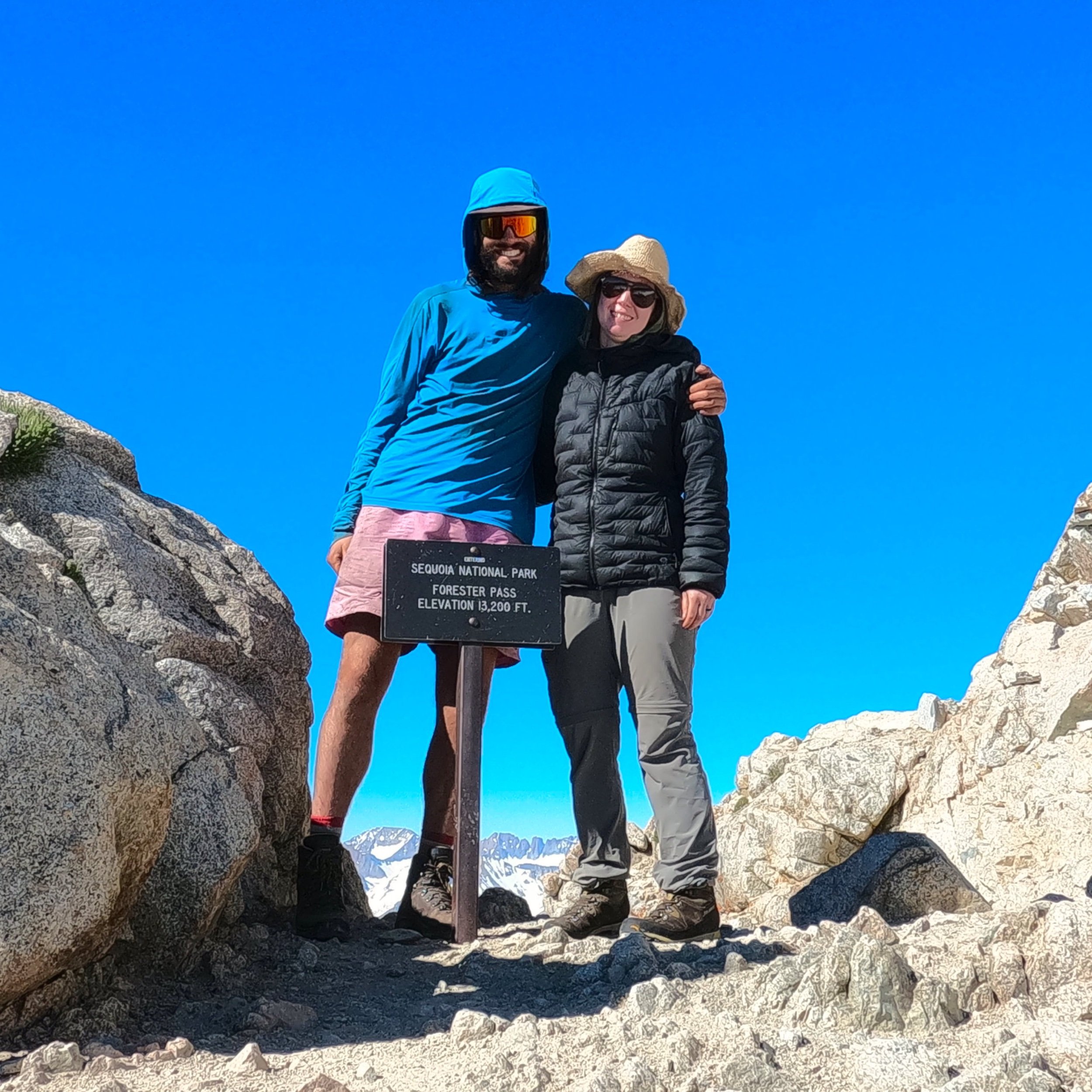
The stage today started out where we had stopped the night before, in a beautiful, high basin below Diamond Mesa, Junction Peak and Forrester Pass. The PCT/JMT progresses north up through the 5 lakes in this basin and goes over Forrester Pass at an elevation of 13,120 feet - the highest point on the PCT. Forester Pass was named after the Forestry personnel that discovered the pass in 1929 and demarcates the border between Sequoia NP and Kings Canyon NP. From here the trail drops into a cascading set of hanging valleys each with their own little lake before dropping all the way down into the Bubb’s Creek river valley along which there are numerous, beautiful backcountry camping spots to choose from. The stage ends under the Kearsarge pinnacles and at the junction for Kearsarge pass which is a popular exit point for PCT hikers to resupply.
Today started at 4. We had agreed to try and be underway by 5. The ranger had told us yesterday that Forrester was shaded most of the day so an extra early start was unnecessary and that the extra light might help us navigate up the lakes basin since the trail was completely covered in snow. Actually, not just the trail, the entire basin - it’s July and we only see 5-10 feet of trail every mile or so. Anyway, I was going to snooze but I saw Wildfire’s red headlamp moving about and felt bad because he was cowboying it and we were warm in our tent so I got up and got a move on. Amanda was a little slower, it was cold-ish - actually it was like 37 but with the breeze that had kicked up over night it felt pretty cold. The stark and imposing scenery that surrounded us also made it feel colder. Eventually Amanda got up and we got our things together. Just before we left, a guy in his mid-20’s showed up from the river valley below. He wasn’t much of a talker but we learned his name was Kyle and he was headed over today as well. Kyle is one of the first people we have seen since leaving Whitney 2 days ago. I can’t stress how crazy this is. It’s July and we are on one of the most coveted trails in the world - not America, the world - and Kyle is the only person we’ve seen in two days. It’s just not a normal year, by any measurable standard. We weren’t quite ready to leave so he departed and we finished preparation. Finally, around 5:20, we stepped off of our little island of rock and onto the sun cups. I know I have described these before but, to reiterate, they are little sunken snow ovals from hell. We don’t see these too often in the northwest because we are usually on a glacier doing these kinds of activities but they suuuuuuck. They are the most inconsistent, horrible surface to walk on and we had to cover 1.5 miles to the base of the pass on them.
We progressed up the little basin. The sun cups where frozen which helped only a little bit. I felt bad for Amanda, with shorter legs, trying to navigate sun cups that were deeper than she could step. It helped if you could span from lip to lip, but that wasn’t always possible and, as they warmed, the lips couldn’t hold weight anymore and you would get sucked into them. At around 8 we reached the northern end of the basin. We had been watching Kyle and he had traversed way to far east at the base of the wall through which Forrester passed - almost to the base of Ski Mountaineer’s Pass - but he had figured it out and was traversing back. We started up the approach - the PCT’s nice switchbacks deep under the snow beneath our feet. Under normal summer conditions it’s not uncommon for a PCT hiker to roll through 3-4 passes a day, but under our current conditions, these passes are practically mountaineering commitments. The approach slope started gradual and steepend half-way to the point where I, up above the other two, called down that they should have their axes ready before getting up to the steep. We had originally agreed to angle for one of the first exposed switchbacks that was way to climber’s left, almost under the chute we were all worried about but Kyle, on his way back, had actually accessed a higher switchback by climbing on top of a rock in the middle of the wall above us and climbing up to the middle of a higher switchback. Looking left at the 50 yard traverse that was going to be required to get to our original goal, I called down for Amanda to head straight for “Kyle's Rock” and Wildfire, who was already under the rock, gave me a thumbs up. We all got to the top of the rock - really more of a boulder - and then Wildfire took the first shot at the class 4 scramble up to the switchback. Again, none of this would ever normally be required in July on the PCT, but these are the conditions we are currently working with. Amanda followed and then I was up on the switchbacks. We took off our spikes and followed Wildfire up to the dreaded chute.
I cannot articulate how ludicrous Forrester pass is. If you were standing down in the little valley we slept in looking at the insane array of peaks around you, you would probably say there was no good way out of it except back the way you came. The 1920’s forest service were composed of psychopaths though and they looked at the tiny notch at 13000 feet, probably with a stick of dynamite in their hand and a cigarette hanging out of their mouth and said - “oh yea - we’re putting a trail there.” Beautiful switchbacks are carved out of the granite 6 feet wide with nothing but air under them for hundreds of feet below in one of the most imposing environments in North America. It’s reminiscent of a time in this country where humans approached nature as something to be tamed, and the JMT is that mentality on display. A trail shouldn’t exist here, and yet it does.
The switchbacks rose for about 400 feet before we rounded a corner and there was the dreaded ice chute we had heard so much about. Maybe it was our harrowing experience on Mt. Whitney but we all took a look at it and breathed a sigh of relief - the fear mongering of FarOut had gotten to us. It was definitly a no fall zone. A fall would likely be fatal but the boot path was way more established than it had been on Whitney and there were pre-existing holes for ice ax self belay. Jeff (Wildfire) went across first, then Amanda and then myself - the whole thing took about 10 minutes. Then we finished off the last 5 switchbacks and were at Forrester pass.
We stopped at the top and took about 30 minutes to enjoy incredible views North. Amanda and I have tried to compare the Sierra to other places we have been. I think the closest would be the Dolomites - the two are sister ranges in terms of stark beauty and severity as well as endless jaw dropping views. Patagonia would be another similar setting given the granite. We ate and talked for a while. We could already see miles of sun cups below us and dreaded leaving our perch but eventually I took some timed pictures of us in front of the pass sign and we stepped off rock onto snow.
The next 5 hours were something of a horrer story - so bad, we just found ourselves laughing at times. The descent from Forrester started with about a quarter mile of sun cups which, since they were facing north and east, had gotten some sun and were unstable. After the quarter mile, which probably took 30-40 minutes to navigate, we walked a north running ridge on a thin band of rock on the actual dirt PCT. This quickly ran out into a steep patch of snow that would have required dedicated ax work to cross so we looked elsewhere. That’s the thing about the JMT/PCT in the Sierra - if the trail isn’t in working order and you take one step off of it you go from tranquil walking to mountaineering skills in a hurry. It’s like the trail is a small concentrated dot of peace that has been carved out of the maelstrom of imposing rock of these mountains. So, with the trail gone, our next best option was a class 4 down climb through an unstable, nearly vertical field of granite boulders - so we took that. An hour of navigating and willing oven-sized rocks not to move brought us back to the PCT. For about 15 minutes we got to actually hike on it and we relished every moment of it but, all good things must end and they did. For the next 3 hours we traveled through sun cups. I won’t say we were gracious about it but we were dedicated and we inched down to the lower lakes of the valley, mostly making about half a mile an hour. There were small islands of rock that we took advantage of but, mostly, it was just hours of jumping from rim to rim of sun cups and hoping they held. We all went down, many times, usually swearing but got back up and kept going and eventually we arrived at the tree line.
In the trees, things just became a different form of terrible. The sun cups disappeared, for the most part, but were replaced by an angled snow field that the PCT was using to drop further into the valley. This would have been fine on trail, but we were on soft snow and traversing was slow. We inched our way down, stopping to get water and take a break after the sun cup fiasco. We thought the trees would help but this was a younger patch of trees, all the same age, obviously the first to have come up after a massive avalanche about 20 years ago and they weren’t much for cover. I know this all sounds negative, and it was brutally hard, but we kept up a great attitude, usually a little cynical but it kept us going. At the end of the day, we were still hiking in one of the most beautiful areas in the world and that was unmistakable to all 3 of us.
Eventually we did get to the bottom of the Bubb’s river valley and started following it further down. This brought us to the next challenge of the day - the crossing of one of the tributary streams to Bubb’s creek. Actually, the tributary was technically Bubb’s creek but it formally became Bubb’s when it dumped out into the bottom of the valley. In any case, we had to cross it. It was not the widest river we had crossed but it was deep and had a lot of flow. 2 options were before us - cross conventionally at the PCT crossing, which some had done. It wasn’t deep but it was really fast. The second option was a log lying above one of the most violent sections we could see, about 30 yards upstream. We agreed to take the log and butt scootch-it across. I went first with my backpack without incident. The log had been cleared on the top so no issue with the scootching. I came back and took Amanda’s bag across. Wildfire went then and almost fell in at the end but saved it and then Amanda cruised across. These crossings always add some spice to the day that I’m not sure is needed.
After the log we entered the final challenge of the day - series after series of avalanche patches. This had obviously been a big snow year for the Sierra but nothing drove that point home like seeing 3 solid miles of apocalyptic avalanche damage along Bubb’s creek. Trees larger around than my torso were ripped in half and everywhere were tangled messes of limbs and trunks - it was absolute chaos. I honestly don’t think the park service will have this cleaned up this year, maybe even into next year. These miles went slow. It was endless bobbing and weaving, climbing and crawling up and over and through to get further down the valley. I think we were a little delirious at this point because we couldn’t stop laughing. From mountaineering to boulder fields to sun cups to river crossings to avalanche tangles - today had everything you could never want in a hike and all we could do is laugh. You know what is crazy to me though - there are people, very few i think, but people who have come before us, done this and said - “you know what i want? I want 300 more miles of this” and are going on north into even more dense snow pack. I brought this up to Jeff and he smiled and said “maybe they like the challenge.” “I like the challenge,” i replied with a smile “but I’d like to finish more i think and that’s not going to happen on 10 mile, 12 hour days.”
Eventually the trail got everything out of it’s system and the last 2 miles were fairly good. We cruised down the trail past a few sanctioned NPS camping sites until we got close enough to the junction of Kearsarge pass that we could feel good about getting out easily the next day. We did our typical evenin activities, thought about making a fire and decided we were too tired and then said good night and went to bed having decided we could sleep into 5, given our superhuman effort today.
I know this post may sound a bit negative and I apologize for this - it really isn’t meant to be. There are no bad days on the trail. There are days I want to end, there are days I really want to end with a beer and a cheeseburger but none that I have regretted. I am becoming more and more convinced that most of the NOBO’s skipped the Sierra all-together and that was probably a good decision but I don't regret continuing north and trying. Some people are good to go on the word of others but we had to see this for ourselves and make our own opinions and I can now officially say that these mountains are just not ready to be thru-hiked. They can be hiked but not at a pace or with the ease they were meant to be this time of year and it all comes down to time. At this point, barring some miracle beta from up ahead, I don't think we will be continuing the Sierra until the Fall, and I’m coming to peace with that a little more each day.


