7/10/2023
Section: Milepost 788.2 to 789.7
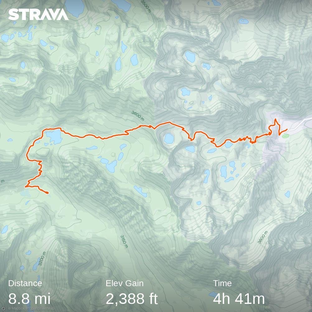
Distance: 8.83 Miles
Moving Time: 04:41 hrs
Elevation Gain: 2,388 ft
Click here for current location
Today, we bailed on the Sierra. We haven’t officially made the decision yet, but I don't think we are coming back till later this summer. I’ve mentioned a lot of reasons for this in the last two posts, so I won't wax poetically about it anymore but, suffice to say, we can't finish this hike in 6 months at 10 miles a day, and that’s about all anyone can do in the Sierra in its current condition. At this rate it would take us another month to finish and that would leave us in the North Cascades in the middle of November which won’t work so, today, we came out on Kearsarge pass and got a ride to Independence, CA.
The stage started at the Vindette campground - one of the many nice places to stay overnight in Kings Canyon National Park. From the campground, the path winds north and upward, climbing back above 10,000 feet on the PCT. At this point, there is an upper and lower approach to Kearsarge pass. One is called the Kearsarge Pass trail and the other is called Bullfrog Lake trail. We took the latter, having heard that it was more snow free. The Bullfrog lake trail winds northeast, crossing on the upper shores of Bullfrog lake before traveling due east through a flat valley and then ascending to a little over 11,000 feet at Kearsarge pass. As the trail ascends, there are beautiful views of the backside of Kearsarge pinnacles. From the pass, the trail descends through a hanging valley bordered by glacial moraine and then through a series of several lakes, each lower than the last. Finally, the trail winds down to the Kearsarge Pass trailhead, where a small parking lot and campground wait for tired returning hikers.
We slept in this morning. Actually, I could have kept sleeping for another few hours. I was wasted after the previous day's battle and both Amanda and I were pretty sluggish, but Wildfire got up and I didn't want to let him down, so I deflated my sleeping pad and started organizing my things. We were in close proximity to the river, which made everything a little colder, but we fought through and got everything together. I made the last of my Brown Sugar Oatmeal and choked it down before we did our warm-ups and hit the trail.
We started up the PCT, hoping desperately that the constant trail interruptions would not be such a feature on today’s stage. We were pleasantly surprised as we climbed up to 10,000 feet to find a smooth patch of dirt beneath our feet. I noticed, for the first time, ferns growing on either side of our path. Just before the turn-off for Bullfrog lake, we ran into snow. It wasn’t bad, but memories of yesterday fresh in my mind darkened the mood a bit. Not long after, we found the junction and turned off. It wasn’t a momentous thing, but it occurred to me that we would likely not be returning to this path anytime soon - that the next time I would exit this way would be several months from now. It was a little upsetting to think this as I was giving up on the dream of completing the trail in one straight line, but I reminded myself that this year was unlike anything in living memory, that finishing was the ultimate goal and that completing the Sierra would almost certainly jeopardize that.
We turned into Bullfrog Lake Trail and started climbing. Wildfire swept behind us, I think so that he could properly depict our location. His wife, Caren, who had given us Pacifico’s and fruit almost 2 weeks earlier in Tehachapi, was coming to give us all a ride down to Independence and was watching his Garmin InReach location. The plan was that she was going to leave around the time we reached the pass to come get us.
We wound up and around Bullfrog lake. The Kearsarge Pinnacles began to dominate the background, and I couldn’t help but think of all the amazing routes that must have been developed through these incredible spires. After Bullfrog Lake, we traipsed east across the valley. Heart lake could be seen in the distance - it really did look like a heart, kind of like Guitar Lake from Whitney. The snow was intermittent, but at one point became solid in front of us.
We all stopped, and I looked at my GPS app. “I think the switchbacks go up above us.” We all looked up and could see the tiny Kings Canyon Sign silhouetted in the pass 700 feet above us. We all agreed to straight-line it up the scree slope above us instead of fighting through more snow. We headed up and, in about 100 feet, gained the first uncovered switchback. From there, we climbed for about 25 minutes before reaching the pass.
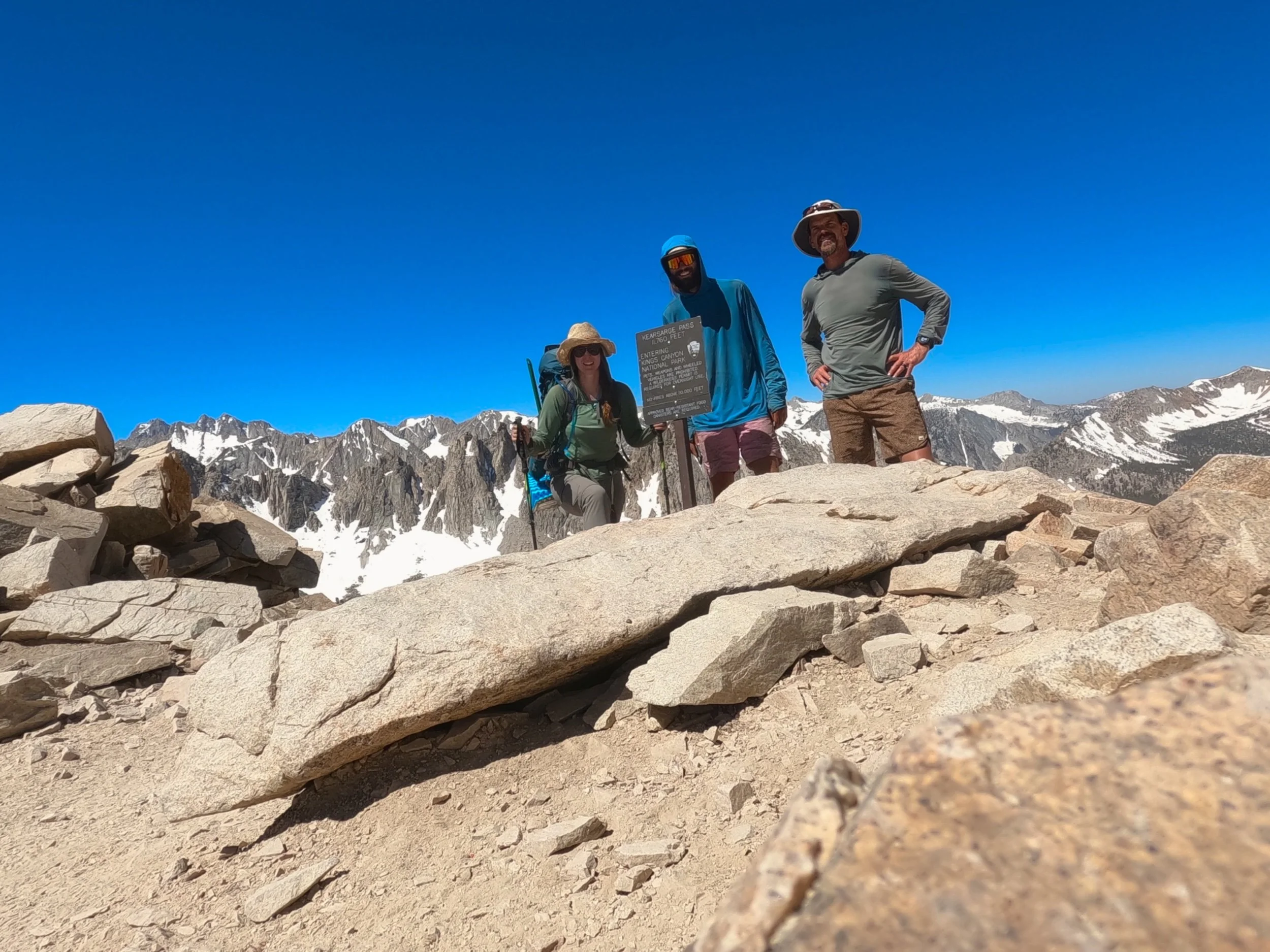
At the top, we all stopped and took in the beautiful views below. A day hiker came up, and we talked to him for a while. He was climbing Mt. Gould, just above the pass, and informed us that the way down was partially snow covered but better after we had dropped the first 1000 feet. We thanked him, took pictures of ourselves around the King's Canyon Sign, and headed down.
The first 1000 feet were sloppy. The sun had warmed the snow and made things very unstable, but at least there was minimal sun cupping, which was appreciated. We wound down and down, occasionally talking with day hikers headed for the pass. Everyone was surprised by the snow. We passed Postpile lake and a number of others. Wildfire informed us that Karen had arrived and was hiking up. “Can’t wait to see her again!” we both said. We hit the middle section of switchbacks and came to Flower Lake and there was Karen waiting on a rock. We walked out and said hi before continuing on, regaling her with all the woes of the previous days.
About an hour more brought us down to the trailhead. Beautiful views abounded all the way down. At the bottom, Karen had brought cold beer, soft drinks and fresh snacks.
We sat at on the ground behind the car, which we all thought was funny because Karen had clearly offered us folding chairs, and talked, enjoying cold drinks. I remember Sean saying a while back that there was nothing he enjoyed more on the trail than cold beverages now, and i have to agree. After a while, our thoughts turned to a burger, and we loaded up to go down into Independence.
Karen and Wildfire were staying in Independence at the Mt. Williamson Hotel and Karen had checked with them earlier about availability. Originally, there had been no spots open, but a last minute cancellation made it possible for us to stay, so we took it. We took a load of dirty clothes back to the office for cleaning before taking showers. It had been a long 8 days, and it felt incredibly good to finally get the miles of dirt off of us. Afterward, we tried to find a place for a burger in Independence, only to find that most of the places were closed, as it was Monday. Finally, we drove all the way down to Lone Pine where we found the Mt. Whitney Restaurant which boasted the best burger in town. We sat and had a great burger and a few brews, relishing the 1st-world convenience of warm food and cold drinks. We talked for an hour or so before heading back to the ice cream shop in Independence, where we tried a number of unique ice cream flavors - including Jalepeanut - which was my favorite.
On the way back to the hotel, we stopped at the county courthouse because it supposedly had one of the oldest groves of planted trees in America. In the back we found them - 2 100-year-old Lebanon Cedars, 2 Deodar Cedars and 2 Sequoias. We talked to a lady named Nancy, who we later found was like the quasi-mayor of the town. She told us all about the trees and the history of Independence and the Owen’s Valley - focusing on some of the more devious activities of the LA Department of Water and Power (DWP).
After, we returned home - exhausted and ready for bed - and turned in for the night, saying we would see both Jeff and Karen in the morning for the family style breakfast.


