
The W Trek, Patagonia
The W Trek, on the far side of the world, is an epic adventure that should be on any trekker's dream list. Patagonia features some of the most breathtaking granite formations on the planet. Whether it is falling asleep to the crescendo of far off avalanches or witnessing the world as it would have appeared in the last great ice age, the southern tip of South America will become the standard all future adventures will measure up against.
Trekked November 2015

Punta Arenas map provided by hostel53sur - an excellent place to stay the night before your trek.

Walking to the bus station through central Punta Arenas - took this picture for our friend... Josh.

Hiking Permit for entering Torres del Paine National Park

Trail Head of the W-trek just east of the Hotel Las Torres

Trekking Rules reference card, must be on you at all times

Crossing over the Rio Ascencio just after the trail-head

If you ever get tired, these guys are available to take your gear

Looking south mid-way climbing into the Valley Ascencio
Day 0: Punta Arenas to Chileno Campground 11/16/2015
Start: Punta Arenas
End: El Chileno Camp
Total Time: ~12 hrs (2 hrs hiking)
Distance: ~6 km hiking
Campground Cost: ~4950 CLP (November Rates)
No matter where in the globe you start, Punta Arenas will most likely be a featured stop-over on the way to Parque Nacional Torres del Paine (Torres del Paine National Park). Despite being one of the farthest southern cities in the world, Punta Arenas is an inviting spot to start this epic adventure. Most flights will connect through Santiago, Chile and, in our case, arrived very late in the night. The Airport for Punta Arenas is ~20 km north of the town proper but taxis are generally good about picking passengers up at all hours. Make sure that a jacket is easily accessible as the wait outside can be a little chilly.
On our trip we elected to stay at a hostel called Hostal 53 Sur. As with almost 100% of establishments in Punta Arenas, Hostal 53 Sur was operated out of a perfectly rectangular, one story concrete building. Getting in the building at ~1 am was a little tricky but a few rings of the doorbell brought one of the kindly proprietors to the door who got us quickly squared away. To fend of the cold and poor heating, the hostel was well equipped with ample blankets and after a hectic trip and long layover in Santiago Amanda and I quickly fell asleep on the souther edge of the world. In the morning we woke early with the goal of catching one of the first buses out of Punta Arenas to Torres del Paine National Park. Breakfast included sausages, pancakes, and the ever common crystalized coffee. After breakfast we quickly gathered our belongings and trapsed out onto the street. We had elected to use Buses Fernandez which was situated ~10 blocks from Hostal 53. A brisk 15 minute walk got use to the terminal but, in one of the more tragic turn of events on the trip, we arrived just as the 7 AM bus leaving for Puerta Natales and had to sit at the bus terminal for ~1 hour waiting for the next bus.
The first day getting to Torres del Paine National Park is a really long one. Assuming you start the morning off in Punta Arenas you will board a bus in the morning hours for Puerta Natales which takes ~ 3 hours. Once in Puerta Natales you need to buy a second bus ticket at the bus station to get you out to Torres del Paine National Park. The lay-over in Puerta Natales is usually ~1 hour which gives you just enough time to go rent any camping gear you will need for your trek. The trip out to the park is ~2 hours and once there, you will take your bags off the bus and go inside the ranger station for a briefing on park rules. After the briefing you will board a thrid bus to take you to the trail-head.
Amanda and i finally got on our Buses Fernandez bus at around 8 o'clock and strarted on our journey to the park. South American buses seem to be very nice everywhere you go on the continent. Amanda and i rode buses from the southern tip of Chili all the way up almost to Columbia and never had a bad bus experience. Contrary to some other areas in the world the buses are impeccable. At around 10:30 we arrived at the bus terminal in Puerta Natales. We purchased our ticket aboard the 12:30 pm bus through Buses Gomez for 7500 pesos and quickly walked to the central area of town to get a tent and sleeping pads.
Puerta Natales is almost a carbon copy of Punta Arenas being comprised of rectangular, flat roofed concrete dwellings and containing many youth hostals. We stopped by a few hostals before finding a place with sleeping pads and a tent. Random note here about sleeping pads. In general you will only be able to get ahold of the old style foam fold out pads that are a few millimeters thick. More and more sleeping bag companies, such as Big Agnes, are designing bags without insulation along the floor of the bag. This is done because it is assumed that you are using a modern style sleeping pad which inflates and provides insulation between you and the ground. This is an excellent idea but i would say that, if you want to use your sleeping bag in Patagonia and it is this newer style, also invest in a sleeping pad to take as well. As it was, Amanda and I had just gotten a double sleeping bag built in the modern style mentioned above and we were not well insulated from the ground with the foam pads we rented in Punta Arenas. This caused a large amount of discomfort sleeping in the park to a point that, on the last night of our trek we simply rented an additional sleeping bag to insulate us from the ground.
After aquiring a couple sleeping pads, a tent, some cookware and some gas canisters we made a quick pit stop at the local supermarket on O'Higgins. Here we were able to purchase all of our food for the trek as well as some snacks for the bus. Don't forget essentials like lighters! On our way back to the bus station we took a detour to walk through the Puerta Natales's cemetary which, like many cemeteries in the country house elaborate structures above the grade. This is a neat walk if you have the time to spare. Back at the station we boarded our bus and embarked on a 2 hour bus ride to the park.
Upon entering the park your bus will stop at the entrance ranger station, referred to as La Estancia Complejo Torres del Paine. Take your things off of the bus - it's most likely taken you as far as it's going to. Your bus is most likely going to travel an additional 3-4 kilometers up the road to Hotel Lago Grey where it will pick up passengers finishing the trek at Lago Grey. I should note here that there are 2 ways to complete the W Trek, from East to West and from West to East. Amanda and i chose to hike east to west. Having done it that way, i can't think of any particular advantage either way. One possible advantage of going east to west is that you may be more strategically located to get an early start and see the sun rise on the Torres del Paine but you can also do that hiking the trek West to East. In any case, if you are hiking west to east on the hike you will have to catch a ferry from the southern tip of Lago Grey and will therefore be going the same way as the bus. If this is your case and you can communicate to your bus driver, try to tell him that you would like to continue riding the bus to Hotel Lago Grey and he may wait for you. If you are hiking East to West, fear not, there are park buses that can take you to both Hotel las Torres Patagonia and Hotel Lago Grey.
The park check-in process is thorough and very official. After entering the ranger station you will sign multiple forms of paper, receive a permit, etc. Then you will attend a compulsory seminar about park rules, wildlife, leave no trace, etc. After the seminar, more paperwork and stamping and you are free! If able and you do not already have one try to get a map. I should note here that we were in the park in what is not considered the high season and the station was out of maps so don't expect to be able to get one there. Your best bet is to order one online a month before you go on your trip.
When Amanda and i finally got out of the station there was a park bus waiting to take us to Hotel las Torres Patagonia. Make sure you have cash and communicate to the bus driver that you want to go to either Hotel las Torres Patagonia and Hotel Lago Grey. The ticket shouldn't be any more than your bus from Puerta Natales. The bus ride is about half an hour and should drop you off just east of Hotel las Torres Patagonia in a campground. If you have extra time you can easily stay in this campground for the night and get a start in the morning. Amanda and i finally got to the campground near the W-trek trailhead at approximatly 4 PM, and, because we were on a condensed time schedule, started hiking. Keep in mind that, in the later months of the year, because you are so far south, the sun doesn't set untill around 10 pm giving you plenty if time to hike, even if you arrive late.
From here forward i will describe the trek assuming an east to west trekking experience, but it should be just as helpful if you are trekking the opposite way. Upon arrival we initially struggled to find the physical trailhead. Look for it behind the main lodge which is less than a kilometer west of the campground you will be dropped of in. At the trail head there is a sign clearly demarking destinations and the route you should follow to get to them. I snapped a quick picture of a map on a board for future reference. Generally Amanda and I found everything laid out extremely well in the park. There are few side trails to get lost on and and enough people along the way to stay sure about your direction.
After leaving the lodge you will cut northwest up a small valley - the Valley Ascencio. This gains around 2000 feet in the 7-8 kilometers up to the first campground called Chileno. One thing that amanad and i learned very early on is that the weather in Patagonia is variable beyond anything we had ever seen. On our first day we started out with gorgeous clear skies, passed through near white out conditions about halfway up to Chileno and ended at the campground with perfect weather. For these reasons i would suggest making sure you have a good layering system. I took with me a regular t-shirt, long sleeve baselayer, a down filled puffy and a shell. If you do this trek in the later months of the year you shouldn't see temperatures too far below freezing and, because of this, i was generally happy with the arangment described above.
At a pretty slow pace amanda and i were able to reach Chileno at around 8 pm. This gave us about an hour of daylight to set up camp. We checked in at the campground office and picked out a spot to pitch our tent for the night. We decided to get up around 4 am to try and get to the Torres del Paine for a chance to watch the sun rise against them. With this in mind we quickly fell asleep exhausted after more bus riding than i had ever done in 24 hours.
Day 2: Chileno Campground to Los Cuernos Campground 11/17/15
Start: Chileno Campground
End: Los Cuernos Campground
Total Time: ~10 hrs (Chileno - Torres - Chileno - Los Cuernos)
Distance: ~22 km (Chileno - Torres - Chileno - Los Cuernos)
Campground Cost: ~49.50 CLP (November Rates)
On Day 2 of the W-trek the walking to sitting ratio is much higher. Amanda and i awoke at 4 to try and reach the viewing area for the Torres del Paine before sunrise. We quickly grabbed our bags, tidied up our site and set out leaving the tent and non-essentials behind. We climed by headlamp up the Valley Ascencio for about 45 minutes before reaching the second campground called Torres. Note here that, if you want the best odds of seeing the Torres as the sun rises i would suggest staying at this campground as it cuts at least an hour out of your travel time up to the lookout. Unfortunatly, it was already starting to get light as we turned left off of the main trail at Torres campground and started our way up to the viewpoint. The light did allow us a chance to see a silver fox slinking away off the trail.
The last leg up to the Torres del Paine lookout is about an hour of travel time and i would say about 300 meters of elevation gain. The last half of a kilometer of trail is generally icy and takes a little more care to traverse but is nothing too difficult to do. As we arrived at the top we saw a group of people had already formed at the viewing area - some looked like they had been there for some time in the freezing cold. I was sad to see that the sun had already risen but the group of people already there assured me that i had not missed a rare "red sunrise" against the Torres, the conditions had not been right. Many of the people left shortly after we arrived which gave Amanda and i some time completely alone with the Torres del Paine. We sat and looked at the towering pillars of granite for about an hour, took some pictures and talked about the crazy 1st day getting here.
After about an hour Amanda had lost patience with me setting up the camera and taking pictures so we started our descent down as people started arriving in earnest. The day was turning out to be a beautiful one already. About an hour and a half of hiking brought us back to our campsite and we broke camp as the day started to warm up. Your destination on the second day, assuming an east-to-west approach, is Los Cuernos. This campsite is about 16.5 kilometers (~10 miles) and most of this is downhill. Maybe 3-4 kilometers heading southeast away from El Chileno campground the trail will diverge. Go ahead and take the right path, it should be denoted with a sign saying "El Cuernos This Way." This trail is a cut over to get you down to the backbone of the W-trail a little faster. Eventually you will drop back down to an elevation similar to the one you started with at the trailhead. One thing i noticed about hte W-trek is that each of the three "legs" of the W takes you up into the mountains while the backbone of the trek is at a constant elevation along the everpresent Lago Nordenskjold.
About an hour after taking the cut-over trail you will drop bag down on the east-to-west section of the trail. The Lago Nordenskjold will be on your left and you will be heading west. From here you wind your way up and down along the giant lake for about another 3.5 hours. This section of the trek has some amazing views and great, flat places to stop, eat and take some pictures. One thing to note hear is that the wind will come up from nowhere! At one point i was using my sleeping pad to sit on and stood up to grab my camera. The wind gusted as i was breaking down my tripod and before i new it the pad was 100 meters away. Fortunatly it got caught in a tree and i was able to get it back.
Amanda and I had left Chileno around 8 am after returning from the Torres and we arrived in Los Cuernos camp at around 3 pm. If you do the math this timing is a bit longer than the ~6 hours suggested to complete this section but Amanda and i spent some considerable time goofing off along the way. Los Cuernos was my favorite campsite along the trek. Most of the sites are situated in a large glade above the check-in station with amazing views of the mountains behind you. The lodge at Los Cuernos also serves a delicious red wine and strawberry concoction that is perfect for the end of a long day with an early start. Check-in at the station near the lodge. When we were trekking in November rates for a night in Los Cuernos was ~50 CLP. Amanda and i ate a quick raman dinner, talked with some other travelers for an hour or so, took some time lapses with my camera and then turned in for another night.

The Torres del Paine just after sunrise

Crossing a bridge...like a boss

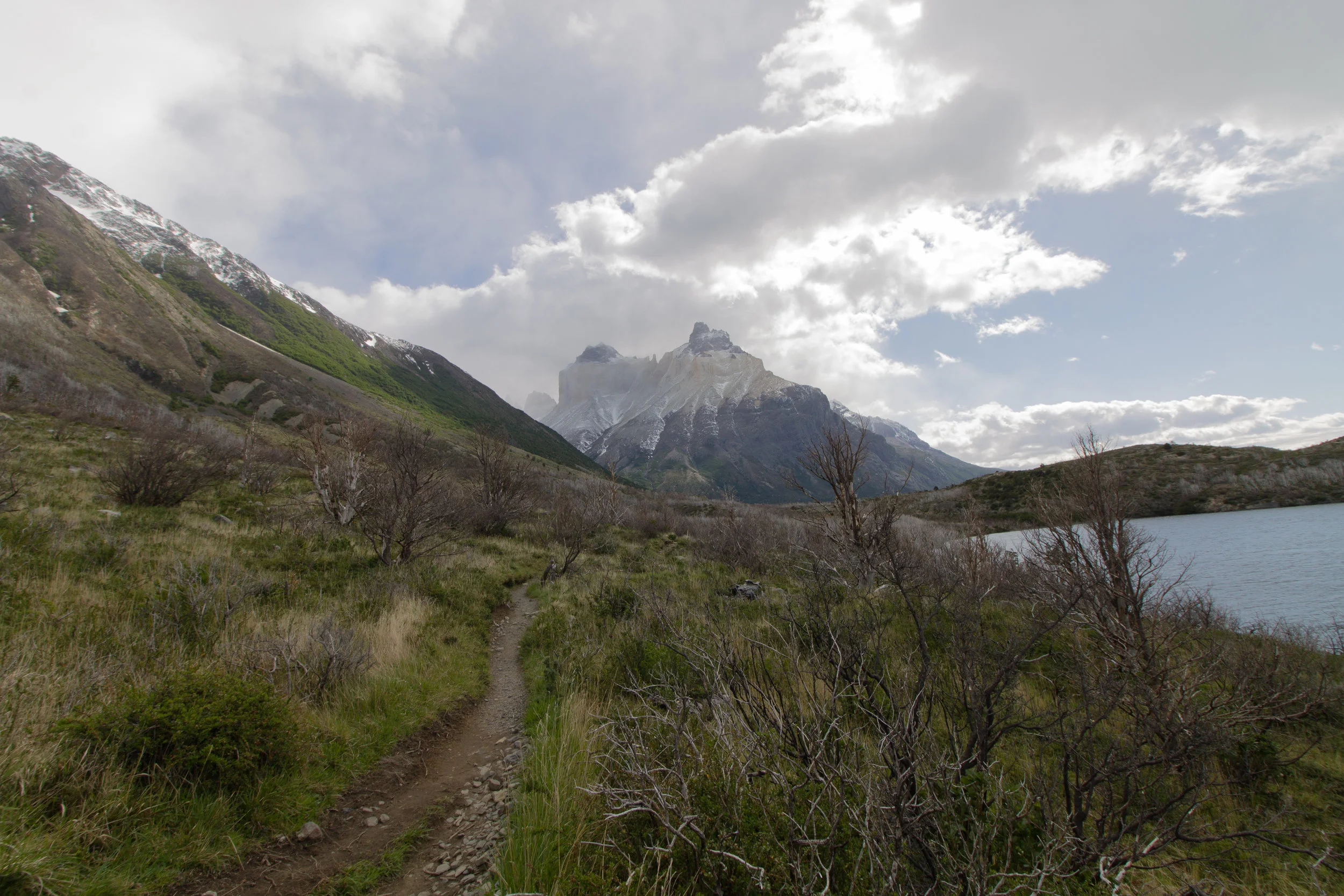
Nice back-drop after turning south-west out of the Valley Ascencio

Again, awesome back-drops for most of this day

Just a reminder, don't do fire. Italiano campground
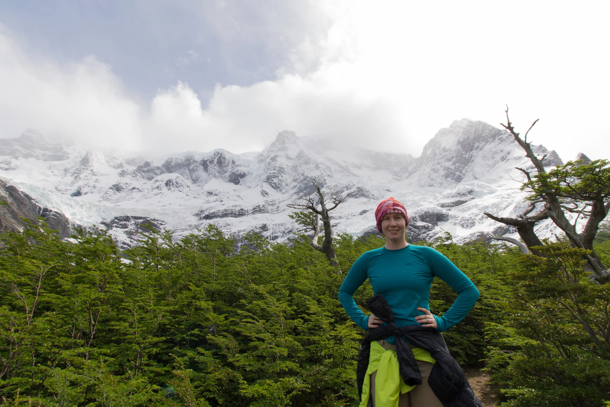
Amanda stands in front of the Cumbre massif

View from just south of Camp Britanico
Day 3: Los Cuernos Campground to Italiano Campground 11/17/15
Start: Los Cuernos Campground
End: Italiano Campground
Total Time: ~7 hrs (Los Cuernos - Italiano - Camp Britanico - Italiano)
Distance: ~14 km (Los Cuernos - Italiano - Camp Britanico - Italiano)
Campground Cost: Free
Day 3 is a little different in the way it is arranged. The distance from Los Cuernos to Italiano Campground is pretty short. This is done purposfuly so that a trekker can get to Italiano quickly, set up camp and then day hike up into the beautiful Rio Frances Valley.
Amanda and i got up and had a quick oatmeal breakfast at Los Cuernos before setting out on the trail at about 9 am. We continued to hike along Lago Nordenskjold quickly warming up and removing layers. It took about 3 hours to travel 5 kilometers to Italiano with plenty of stops for pictures and conversation. Somewhere before Italiano you will cross over some sort of unmarked boundary in the park. I have yet to fully understand what the boundary is but my understanding is that it is similar to crossing between a "national forest" and a "national park" in the United States. What this simply means is that Italiano is not allowed to be a more commercialized campground with a lodge and cabins - instead it is a primitive campground similar to a backcountry campground in the states. There is no water and nowhere to buy food/rent apparal. As we were outfitted with everything for backpacking this worked out just fine with us and we quickly went about finding a campsite. Note here that if you are hiking in a semi-assisted fashion, renting items from the more commercial stops that you may need to stop at Domos and Camp Frances, about 2 km prior to Italianos to get the items you need. One comment about water along the trail, there is plenty of it and it appears very clean. Many people told us that they were just drinking out of streams along the way. While i'm sure this is fine Amanda and i usually travel with a SteriPen and so i UV treated all of the water I drank - it only took a little while longer and it ensured no unwanted illness along the way.
After picking out a spot in Italiano, amanda and i packed a day bag and headed north along the Rio Frances. This may be one of the most impressive river valleys i have ever seen. Immediatly as you head north you are met by the sight of the Cumbre massif in a constant state of shedding snow in the form of huge avalanches rolling off of its flanks. The trail initially climbs steadily for 30-40 minutes to get up into the valley proper through some short trees. Look for Chilean Blue Eagles ("Little Eagles") soaring on thermals above the valley floor as you come up the trail along the Rio Frances. After about an hour the trail will flatten out and you will find yourself surrounded north, east and west by beautiful granite formations. On the day that we climbed up into the valley, the trail to Mirador Britanico was unfortunately closed about half a mile beyond the point where the trail flattens out due to unstable conditions. We founda high flat rock to sit down on, eat and take in the views surrounded by 360 degrees of impressive granite formations. Total time from Italiano to near the Camp Britanico was a little over 2 hours with plenty of stops to take in the views. After a quick lunch we headed back down to Italiano.
Once back we set to work preparing dinner which consisted of some quick and easy raman noodles and jerky. There were quite a few people at Italiano, around 15 individual groups. Many of us gathered around in a circle at the center of the camp. Another couple from Ireland shared some whiskey with us and we talked for a couple ours about the trek and our homes. Eventually we all made our way back to our tents and passed out listening to the massive and consistent avalanche activity coming from the Cumbre massif
Day 4: Italiano Campground to Refugio Grey via Guarderia Pehoe 11/18/15
Start: Italiano
End: Refugio Grey
Break At: Guarderia Avanzada
Total Time: ~8 hrs (Los Cuernos - Guarderia Pehoe - Refugio Grey)
Distance: ~18.6 km (Los Cuernos - Guarderia Pehoe - Refugio Grey)
Campground Cost: 5000 CLP (~8 USD)
The next morning we woke around 8 am and slowely started picking-up our site. Italiano is probably the coldest campground on the trek as it sits in a shallow bowl and there are shady trees that prevent the sun from effectivly warming the area. After packing and breakfast it was about 9:15 am and we eventually started walking around 9:30. After crossing over the Rio Frances we turned south-west and started making our way to Guardia Pehoe at the north-west mouth of Lago Pehoe. As we walked we had a constant view of the Cumbre massif to our right and Laguna Scottsburge on our left. Behind us Cuerno Prinicpal loomed high above last night's campsite and in front was wide open space. Elevation gain and loss is negligable between Italiano and Guarderia Pehoe which allowed us to make quick time between the two. We arrived at the guard station/lodge in under 3 hours and stopped to have lunch. The Guarderia Pehoe complex is a series of several building meant to accomodate trekkers and tourists who take the ferry from Guarderia Pudeto to Guarderia Pehoe. Keep in mind that if you compete the trek from west to east (opposite of what we did) you will start your trek here, at Guarderia Pehoe and proceed north to Lago Grey. The lodge at Guarderia Pehoe accepts credit card and has many ammenities that are much appreciated after several days of trekking. Amanda and i recieved a basic cafeterria lunch and sat in front of a big glass window looking out on the mountains north-east of the lodge.
After about an hour we started walking again heading north and slightly west towards Camp Grey. The expansive Lago Grey stretches north alongside your left as you walk and giant blocks of ice can be seen breaking through its perfect surface. While there are no major altitude gains in this section the trail does gain and loose 3-400 feet peridically making this half of the days trek a little slower. It took us about 4 hrs to walk between Guarderia Pehoe and Camp Grey with plenty of photo stops and also one break to watch some huge rabbits chase each other around. Just after 5 pm we crossed over a small stream and rounded a bend which opened to Camp Grey. The camp has a large open field that slopes upward slightly with many spots for a tent. They also have a confined cooking area and plenty of box wine to purchase. Amanda and i set up our tent and headed to the refugio rental center to rent a second sleeping bag for the night. We had realized the night before, in Italiano, that our awesome new "backcountry bed" from Sierra Designs was designed to be supplemented with thick sleeping pads as there was no down built into the ground side of the bag. The 3 mm pads that we had rented in Puerta Natales were woefully ill-equipped to prevent our body heat from leeching into the ground and we had been very cold all night. To prevent this we rented a 0-degree bag from the refugio and put that down beneath our sleeping bag to fix the problem. After that we headed to the cooking area, stopping to grab some boxed red wine on the way, and prepped another quick noodle meal. We talked with some fellow Americans from the east-coast and shared some Mate. After dinner we walked out to the middle of the camp area and took some time to stare up at the stars which were perfect with no light pollution. Finally we retired to the tend for a wonderfully warm night of sleep.
View looking back at Cuerno Principal behind us

Stopping for a break at the Guarderia Pehoe

Looking north to the head of the Grey Glacier

Head of the Grey Glacier seen from one of the many suspension bridges crossed this day

Floating ice - a true novelty
Day 5: Refugio Grey to Grey Glacier to Refugio Grey 11/19/15
Start: Refugio Grey
End: Refugio Grey
Break At: Grey Glacier
Total Time: ~4 hrs (Refugio Grey - Grey Glacier - Refugio Grey)
Distance: ~10 km (Refugio Grey - Grey Glacier - Refugio Grey)
Campground Cost: 5000 CLP (~8 USD)
With an extra day we decided to accompany a friend that we had made along the way on the first half of her trip to Camp Los Perros on the Q-circuit (an extension of the W - trek). We started around 9:30 and walked along Lago Grey until 1 pm, when we reached the head of the Grey Glacier. Among the many impressive features in Torres del Payne National Park is the glaciers. Walking along one of these frozen expanses of water is like a peek at what the world must have looked like during the last ice age. The Grey Glacier is massive and extends north beyond the horizon in a never ending procession of jagged ice. It is truly impressive. Amanda and i said adieu to our friend and stopped to eat a quick lunch before heading back to Camp Grey. We walked back enjoying the long suspension bridges along the way over some deep gorges. Before reaching the camp we walked down to Lago Grey to touch the water and see some of the large floating chunks of ice. We stayed for about an hour before heading back to camp for some dinner and socializing and then enjoyed another warm night.
Day 6: Refugio Grey to Punta Arenas 11/20/15
Start: Refugio Grey
End: Punta Arenas
Total Time: All Day
On this last day you will get to walk, take a boat and a bus. We started at around 9 am, ate the last of our breakfast and made our way south along Lago Grey to Guarderia Pehoe where we had stopped two days before for lunch. At Guarderia Pehoe we had a snack while waiting for the ferry. The ferry ride is about 30 minutes and runs many times a day between Guarderia Pehoe and Guardia Pudeto where the buses pick up to go back to Puerta Natales. Once we heard the ferry was approaching we stepped outside and walked down to the dock snapping a few pictures on our way down. The day was gorgeous and there are some beautiful views just outside the Guarderia Pehoe lodge. The ferry staff helped get us and our bags on board and then we found a scenic spot to sit and watch the mountains go by.
30 minutes later we disembarked the ferry and were met by a Gomez bus shortly after. This bus shuttled us back to Puerta Natales and from there we chartered another bus to Punta Arenas where we spent another evening at the Hostal 53 Sur arriving at a slightly better time than our first encounter there.

View of the park from the ferry - actually one of the better views!


Day 7: Extras 11/21/15
With an extra day in Punta Arenas, a fun option is to go see Magdalena Island and watch the adorable Magdalena penguins in their natural habitat. There are many tour operators in the Punta Arenas area to choose from. A tour will take about half a day and generally starts pretty early. Our tour took us to several islands though we only got off on Magdalena island to walk down carefully designated pathways among hundreds of penguins. The trip was a blast.
That night we packed up our things and took another taxi back out to the airport where we boarded a plane and headed north to Bolivia and the rest of our trip. To this day the W-trek still holds out as one of the most visually impressive treks i have been on. Its combination of extreme landscapes and sheer, brutal beauty make it one of the world's greatest treks. I hope that you enjoy your time there as much as we did.