
Trekked: December 2017
The Simien Mountains, Ethiopia
“One foot in front of the other, just keep putting one foot in front of the other,” I kept saying to myself in a voice like Dory from Finding Nemo. It is the 7th of December and my wife and I are halfway through a semi-independent 5-day trek in Ethiopia’s Simien Mountains National Park. The park has been beautiful so far, with no end of wildlife or panoramic views. The element that we are still struggling to overcome is the altitude. While the local elevation gains and losses have been no worse than those of our favorite park at home, North Cascades NP, our starting point was at the same elevation as the summit of Mt. Baker, and the trail has only gone up from there. I turn to my guide and smile “Like 5 more minutes, then we reach the top?” He and I both share a laugh, we’ve only been climbing for 10 minutes.
The Simien Mountains reside in the northern region of Amhara, Ethiopia and are constituted as the Ethiopian Highlands. The mountains, formed by lava outpourings over 25 million years ago, were formalized as a World Heritage Site by UNESCO in 1978. While technically classified as mountains, the area is more similar to a high plateau that rises suddenly out the rolling lowlands of Ethiopia thousands of feet below in one. It is upon the precipice of this “shelf” that the classic 5-day Simien Mountain trek teeters on, offering limitless views of wild rock formations and the beginnings of the Sahara desert beyond. For me, what makes the Simien Mountains so visually and geographically stunning is that they stand at a drastic transitional zone in Africa. Immediately south of the Simiens, for thousands of miles, the land is lush and green approaching the equator. Immediately north of the trek the climate turns dry and arid all the way to the Mediterranean. On this trek you will walk amidst the clash of two dynamically different climates and be reminded of that fact simply by looking left or right at any given moment. If the geography fails to impress you, then the wild life surely will. The Simien Mountain Range is the sole home of the Gelada Monkey, a baboon like animal that sports a bright red triangle feature on it’s breast. These monkeys travel in families of up to 60 individuals and feed on the tough “tef” grass that grows in the highlands. It is almost impossible to not stumble through at least 2-3 of these large groups while on your trek. I found them to be highly photogenic. In addition you will also see Meneliks Bushbuck, Walia Ibex, Mountain Goats, and possibly a Klipspringer. If you are very lucky you might catch a glimpse of the Ethiopian Wolf which numbered around 100 in the park in 2010. The itinerary below is typical of the classic 5 – day route but there are many variations possible which can be discussed with your guide.


Don't miss Tomoco Coffee!!

Stop for lunch at Traditional Dashen restaraunt
Day -1
Date: 12/3/17
Start: Addis Ababa
End: Gondar
Regardless of where you start in the world, a trip to the Simien Mountains will require a trip through the capitol city of Ethiopia, Addis Ababa. Ethiopian Air, which has established itself as a solid airline is growing fast and services most corners of the world, but other airlines can get you to Addis – including Luftansa which is what we took. For anyone who has trekked in Nepal, Addis could be compared to Kathmandu. It is a large and unremarkable city with few attractions worth more than one day’s stay. From the airport you can take one of the yellow airport taxis to just about anywhere in the city. One nice feature about the airport is that they do not let outside taxi’s close to the terminal, so you do not have to worry about being accosted by 100’s of rabid taxi drivers vying for your business upon arrival.
If you arrive early on your first day in country, you may be able to get to Gondar that same day but honestly that is pushing it. We arrived at 9 pm and ended up staying two nights in Addis to get our bearings. Mr M’s Cozy Place provides the best value stay in the city at time of writing. Despite the odd name, it offers solid accommodation at a good price. For a vast majority of outside visitors to Ethiopia flying is going to be the best option getting around in the country. Unlike America, flights through Ethiopian Air, when booked in country, are laughably cheap and are also drastically more safe and dependable than ground transportation. Try to book your flight in country unless your timeline is very constricted and requires advanced booking. Almost all domestic flights are well under 100 USD if booked in Ethiopia. One caveat should be mentioned about the booking prices. Technically, these cheap flight deals are only available to those who flew into Ethiopia on an international Ethiopian Airlines flight, however, it is pretty easy to talk your way into this discount at the office. For example, implying that a leg of our trip was operated by Ethiopina airlines was enough to activate the discount in our experience. One day in Addis is more than enough time to book a flight through Ethiopian airlines as well as see some of the more significant sights in the city including the Red Terror Museum, the Piazza, Tomoco coffee, and the Natual History Museum which features some of the oldest pre-human remains on the planet. Traditional Dashen restaurant is an excellent place to eat when you get hungry. One final note – Addis is a very spread out city and so it is actually common for tourists to contract a taxi for a half or entire day. This will cost between 1600 and 2600 birr (50-70 dollars) but is worth it if you want to see the whole city and the taxi drivers make pretty good tour guides.
Day 0: Addis to Gondar
Date: 12/4/17
Start: Addis Ababa
End: Gondar
In the case of our trip, we were unable to get a morning flight to Gondar and had to settle for an afternoon flight. If this happens to you, or if you want to take a day in Gondar then a good place to stay is Lodge du Chateau. While a little on the spendy side, this guest house is in walking distance of all the major attractions and offers several tourist services that are appreciated. Gondar is a larger city that again, is not an “inspired” tourist destination. A day here allows you to get some last minutes provisions for your trek including food and stove fuel. Some recommendations for your prep day in Gondar. First, keep in mind that you will need to get to Debark, which is where the national park headquarters and start of the trek, is located. The most economical method of getting to Debark is aboard a mini-bus. Mini-buses leave Gondar several times an hour and can be “chartered” right before leaving, but it is a good idea to get eyes on the bus station before leaving. The second thing you may need is gas for a stove. On international trips we tend to use our MSR Dragonfly International, because it is often difficult to find butane canisters in many developing countries but you can always find kerosene, diesel or other distillate. To find fuel we started at the obvious spot – a gas station. It turned out that the gas station we chose did not have Kerosene, which I had asked for, but the attendant knew of someone who sold Kerosene. You will find, in Ethiopia, that this is often how things works – someone knows someone who knows someone who can get you what you need. Ten minutes after stopping at the gas station we were delivered to a stranger’s house who invited us in to sit and have coffee and then disappeared for 15 minutes only to arrive again with 2 liters of “Kerosene” (I work as an engineer in a refinery, and I’m pretty confident what we got was not Kerosene). Out of curiosity and because we were short on food for the trip, we also asked this stranger if he could also get us lentils – which he was more than happy to oblige and left again only to return with a kilo of red lentils. Altogether the gas and the food ran us 600 Birr but we had what we needed and had survived the ordeal so we took our goods and left, set for our trek.

Gondar airport

Taxi ride into Gondar

The Swimming Pool in Gondar

At the entrance to the park

Entrance Ticket - your scout should also have a small stub for entrance

Check our ride!!
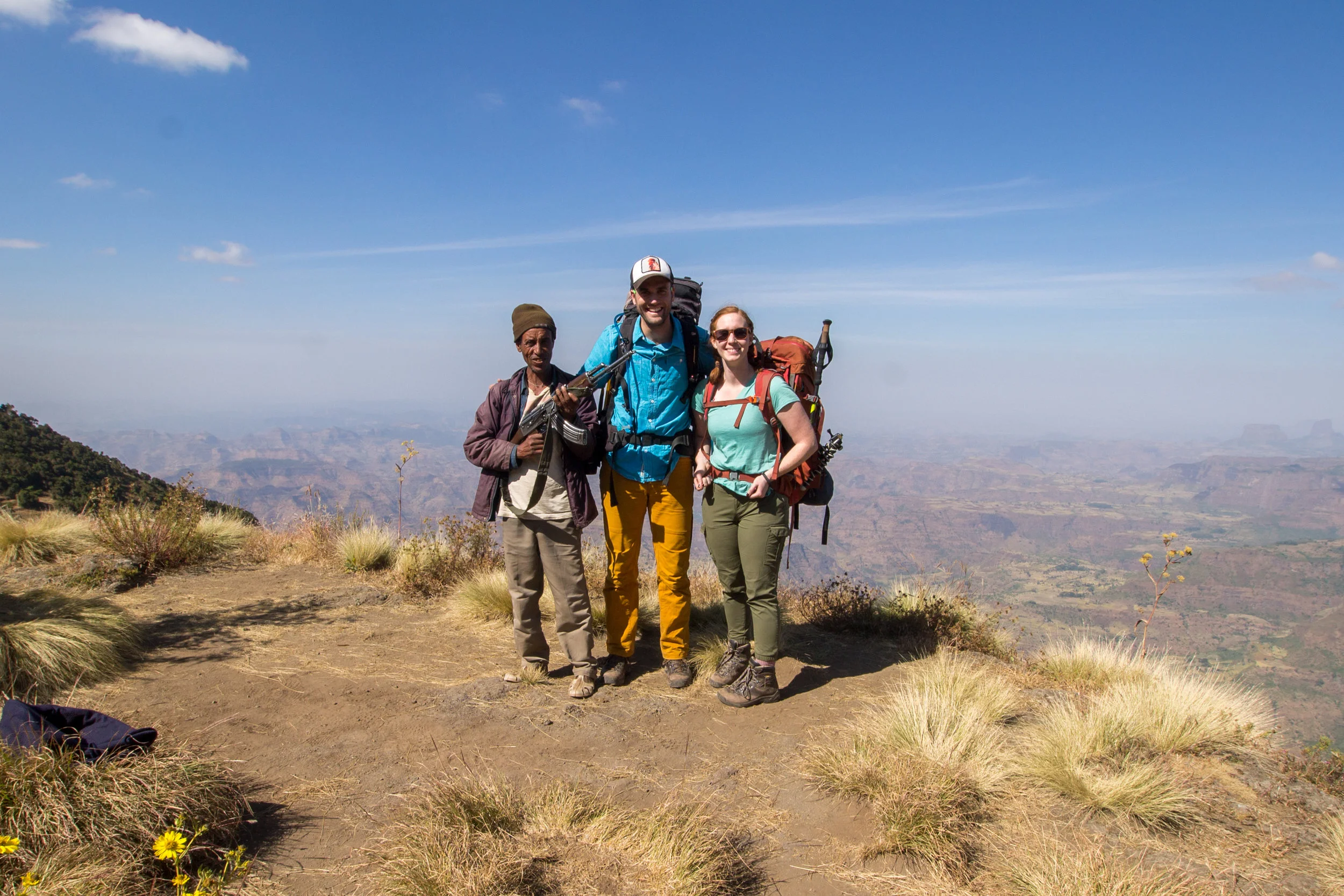
Amanda and i with our scout

First Gelada monkey of the trip

Non-stop scenery from start to finish

Amanda arrives in Sankabar at the end of the first day
Day 1
Date: 12/5/17
Start: Gondar
End: Saankabar Camp, Simean Mtns NP (13.230611, 38.040639)
Total Distance: 4.60 Miles
Total Altitude Gain: 600 Ft
Time: 3 hrs
In the morning Lodge du Chateau offered some wonderful breakfast and we took it early because we weren’t sure what to expect from the day ahead. Note that Lodge du Chatea offers free luggage storage service if you ask for it. This is nice because I often travel with a bit more than I would like to actually backpack with, so I usually depend on being able to store some luggage at a guest house if possible. We left the lodge at around 8 pm and got a taxi to the bus station. I am going to be honest with you here, of all the experiences in Africa, the mini-bus ride probably got my adrenalin going the most. Amanda and I have taken mini-buses and buses before, in both Nepal and through many areas in south America including Bolivia and Peru – none of which prepared us for this experience. The bus station in Gondar is pretty much an open courtyard the size of 1-2 football fields. Upon arrival at the station we were…very noticeable which meant that we were very quickly solicited by 5 different proprietors. The key is to shout your destination and allow yourself to be delivered to the next departing mini-bus. Despite what is probably the most chaotic scene you will have ever encountered you have to operate on faith for about 60 seconds which will get you to an available bus. Once there, your luggage will be put on top of the bus and, if you are lucky and early you will be ushered to your seat in a generic Toyota transit van. Keep in mind that these vans were originally intended for ~12 people but you will witness incredible acts of creativity that will somehow allow 14, 15 or even 16 people onto that van – a random stranger sat on my wife’s lap for about an hour of the trip to Debark. I should also mention that, for all of the chaos and uncertainty – the ride was actually a really neat experience, was very cheap, and all of our luggage arrived with us in Debark. The bus ride between Gondar and Debark is around 2 hours. There is a high likelihood that the minibus driver will take note of you and will, without any direction, drop you off in front of the national park headquarters at the perimeter of town, assuming that you are there to trek. Whether this is the case or if you walk from the mini-bus station in Debark, make your way to the front office of the national park compound to start the entry process. A few things to note about the process of getting your entry paperwork at the office. First, the National Park staff does not inhibit the operation of private parties within the bounds of the headquarters; you could literally be solicited as you attempt to sign the paperwork in the office for an assisted trekking experience – which I found highly irritating. Park entrance is ~200 birr per day, which works out to 1000 birr (~30 USD) for a 5 day trek. The only other required element for trekking in the park is that you hire a “scout” for the journey. Scouts are usually older men in their late 40’s and early 50’s that accompany you on the trek and carry an AK-47 for protection (I never saw, on the entire trek, any reason for them to carry a weapon). A scout will run you ~125 birr (4.15 USD) per day which is about 750 birr (25 USD) for a 5 day trek. Additionally, Amanda and I opted for a guide to accompany us on the trek. We did this because we had heard of issues in the past in parties that only hired a scout associated with the language barrier, because the scouts do not speak English. Hiring a guide necessitated leaving the front office of the national park headquarters and walking 25 feet to the “guide office.” We had read in the Lonely Planet Guide book (unbeknownst to us outdated by 4 years) that a guide should run about 250 birrs (9 USD) per day. To my chagrin it was explained to me that the rates had changed and now guides were 450 birr (15 USD) per day for a 1 - 5 day trek, 550 birr for a 5 – 10 day trek, and 650 birr for a 10 – 15 day trek. We hired a guide, Endalk Mulate, for five days. There are two additional things that should be done from here. If you need additional camping gear you can also rent it at the park headquarters. Whether or not you personally need gear there is another person you should rent gear for, and that is your scout. No one and nothing I have read prepared me for this but most nights in the Simiens are below freezing and, while your guide will generally rent a room at a local village lodge, your scout is required to stay within 5-10 meters of your belongings to “protect them.” Most scouts are poorly equipped, taking no more than a thin blanket. I spent every night in the Simiens just barely warm thinking about how my scout was just outside my tent freezing and I found it upsetting that there was no warning. A lot of the other independent trekkers we were with felt the same. Even if you have your own stuff, a sleeping bag will only run you a few birr a day and it’s a small price to pay to keep your scout warm at night. The second thing you will want to get from the national park headquarters is a car. When I initially read about the trek, it appeared to me that you could walk right out of Debark to the mountains. I can safely say now, that I am glad we did not do that. Even after being totally extorted for round trip car service I am still glad we did not try to walk from Debark to Saankabar on the first day – it is a very long way and has some pretty stout elevation gain. I am ashamed to say we paid an organizer, “Peter,” 2600 Birr (~100$) for a car drop off and pick-up service, but we wanted to get moving and didn’t want to doddle around in Debark trying to get service out to the park. I know that there are big green buses that run service out to the villages in the park, but do not know where they pick-up from in Debark. If you have time and a desire you could try to figure out where the buses originate from and, theoretically, save some cash. So, once you have your guide, scout, and transportation, you are set to go. The whole thing cost Amanda and I about 125 USD per person (without tip), which we were pretty happy about given that we had been quoted 400 USD per person for an organized trip in Gondar and had heard prices as high as 1200 USD per person if booked on-line.
After organizing the necessary parties we all walked about a quarter mile down the street to the waiting van. I stopped at the Commercial Bank to grab some more cash before loading up while Amanda grabbed some last minute snacks. We finally got on the road to the park at around 11:15 am. Half of the drive was on asphalt but once the van hit gravel we slowed way down. About 30 minutes of driving put us at the park boundary where we stopped and took some shots. At the entrance to the park you will be asked to present your park entry permit and your scout will be required to show his license to take you in. Endalk was very helpful in facilitating this process. Shortly after the park entrance we passed by the Simien Lodge. I was curious about the lodge having considered staying there the first night. I asked Endalk about it. He looked at me and smiled, “Very expensive, like 200 dollars a night.” The van dropped us off about a mile past the lodge and we started hiking around 12:30 pm. As mentioned above, a majority of the trek teeters on the precipice of the Simien shelf and, for most of this first day, we kept near a sharp drop on our left side affording amazing views the whole way. It took only about 1 hour before we found ourselves among a family of 30 Gelada monkeys who were more than happy to pose for the 15 minutes we spent taking pictures of them. Endalk stopped us several times to talk about the local plants and sights, all of which was very interesting. Along the way we ran into another couple trekking independently from Israel and eventually met back up with them in camp. Total time traveling was 3 hours and distance was 4.60 miles. Net elevation gain was 600 feet. We arrived in Saankabar camp around 4 pm and began setting up. The camps are generally open fields with lots of spaces. We did hear that, later in the year, these sites get very full. That night I had a small scare when my stove wouldn’t light. After about 20 minutes of fighting with it I figured out how to get it running and, once it was running, discovered that whatever fuel I was given actually burned very well. After enjoying the stars we eventually turned in for the night.
Day 2
Date: 12/6/17
Start: Saankabar Camp, Simean Mtns NP (13.230611, 38.040639)
Lunch: Jinbar River Crossing, Simean Mtns NP (13.245620, 38.088910)
End: Geech Camp, Simien Mtns NP (13.268450, 38.108610)
Total Distance: 8.47 Miles
Total Altitude Gain: 1050 ft
Time: 6 hrs
Day two started from Saankabar camp. Having not quite adjusted to the time zone change we were awake at 4 am, but struggled to get out of the tent before six. After a breakfast of oatmeal and some time in the sun for our damp tent, we were set to go. The second day takes you by several highlights in the park, first and foremost of which is the Jinbar River waterfall. In the morning you will hike down to an observatory on the opposite side of a gorge from this waterfall that offers a great view. Here we stopped for a quick snack and some pictures. Endalk told us that a few years back an Italian couple had actually rappelled down to a small shelf at the side of the waterfall and spent the night there. After our snack we had to climb up and out of the gorge to regain the main road heading east. This was a pretty stout climb but just shortly after the observation point we ran into 3 wild Klipspringer which Endalk indicated were rare to see. Along the way Endalk walked us through some basic vocab in Amharic. After about 30 minutes of climbing we reached the road and turned east heading toward our next break point, the Jinbar river crossing. We followed the road for a short distance before turning off onto another trail. We would not return to the road until the final day of our trek. After turning off the dusty road we slowly made our way northeast into the Jinbar river valley, dropping roughly 200 meters to the river where we stopped for lunch. Along the way we ran into 2 large families of Gelada Monkeys who were more than happy to pose for pictures. At the river we stopped for lunch and enjoyed a good soak in the river. The guides washed their clothes so I headed upstream to get clean water. The Jinbar river was very clear and, while it did not require any filtering, I did treat it with my steri-pen. After lunch we began a slow and relentless climb up to Gich on the north side of the river. I will say that, looking at the map, the topo lines make the climb look moderate but it was a tough one. Every time I thought we had reached the top there seemed to be another ridge on the horizon. As we climbed, Endalk pointed out the Yucca looking plants, called Lobelia, that had started to become a common sight at these altitudes. Soon we crossed through a small tributary of the Jinbar river trickling out of the mountains and just beyond started to notice abandoned structures. 15 minutes more on the trail we came upon the old abandoned city of Gich. According to Endalk, UNESCO paid the people originally residing in the town to move to Debark in an attempt to bring the park back to it most natural state and is continuing the same process with established towns throughout the park. Shortly after the old town of Gich the climb became more moderate and we eventually arrived in Gich Camp.
After setting up our tent and sorting everything out we swapped stories with an English couple who had been close behind us most of the day. Two jackals came close by the site looking for some scraps of food. I followed Endalk over to the only established building at the camp where I was able to buy some Daschen beer and Endalk asked if Amanda and I would be interested in coming back later that evening to have some Injera and Shiro which I agreed to. About 1 hour before sunset, Endalk said we should start heading up to a nearby mountain top, called Kedadit, to watch the sunset. Despite that fact that walking was pretty much the last thing we wanted to do at that point, we grabbed a light and some warmer clothes and headed for the ridge. If you do this hike, do not pass up on this opportunity – it was one of the most amazing views we saw the entire trip. Soon after reaching the top of the ridge the sun started to pass through the horizon casting some wicked light on the edge of the Simiens. Standing at the edge of a sheer kilometer drop as the day transitioned to night looking out on the beginnings of northern Africa left me in disbelief. Once it was too dark to see well into the distance we flicked on our headlamps and began our descent back to camp. Once back we dropped our gear and followed Endalk to the shelter southwest of our campsite. Stepping back into a dirt kitchen we found two girls were making Injera and Shiro. Endalk introduced us to many of the guides leading the other groups and I wrote down many of the words he had taught us throughout the day.
Slow – Kasbekas
Strong (with Strength) - Tenkar
Hello - Selam
Cheeper - Rekashe
Handsom - Konjo
The Injera and Shiro was amazing – probably the best we had in country. We gave the girls 300 birr, thanked everyone and headed back to the tent. The cold was already setting it. Once back we settled in for another night high in the Simiens.

Amanda and I posing early on Day 2

Looking back into the Wazla River Valley

Rare Klipspringer on the trail

Amanda and i posing in front of the Jinbar River Falls

Gelada monkey chillin' on a rock

Sunset on Kedadit

Just before sunrise at Geech Camp

Looking down from Imet Gogo

Amanda looking back up at Shayno Sefer
Geech to Chenneck Ele. Profile

View of the high plateau from the outskirts of Chenneck

Heading for Chenneck!

Lazy Afternoon in Camp
Day 3
Date: 12/7/17
Start: Geech Camp, Simien Mtns NP (13.268450, 38.108610)
Lunch: Shayno Sefer, Simien Mtns NP (13.270914, 38.156418)
End: Chennek Camp, Simien Mtns NP (13.261446, 38.194040)
Total Distance: 9.68 Miles
Total Altitude Gain: 2370 ft
Time: 8 hrs
Day three has some of the best scenery along the trek, but it makes you work for it. We woke early, around 0630 and I was able to take some epic long exposure pictures of the tent while Amanda was waking up. Geech was my favorite camp of the 3 because it had an other-worldly, top of the earth kind of feel to it that was enchanting. After Amanda had cleared out the tent, we gave our scout our sleeping bag so he could warm up and grab an hour of sleep before we departed. Amanda and I enjoyed some Quaker Quick Oatmeal and Endalk eventually turned up ready for the hike in his typical skinny jeans, converse, and sweatshirt. At around 8 am we set off towards our first highlight of the day, Imet Gogo. To begin Day 3 you will walk along the edge of the plateau for about an hour traveling east and slightly north from Gich. Eventually we reached a flat spot where our scout stopped and sat down. Endalk indicated that we should drop our gear and that we had a short walk ahead of us to Imet Gogo. 15 minutes more of walking brought us to an epic view looking northeast into the Ethiopian lowlands. Endalk indicated that, with 15 days he could take us out into this area and that he had done it many times. Amanda and I sat down and ate a quick snack taking in the amazing views. I joked that we should come back and start a golf course and resort way out here. From the lookout we could look south and see where we had yet to go. This was slightly disheartening because the route dropped around 1000’ to a shallow valley before making it’s way back up to Shayno Sefer, which Endalk indicated would be our lunch stop. After about 15 minutes on Imet Gogo we set-off back to meet up with our scout and shoulder our heavy packs.
The next hour was spent carefully winding back down into the Jinbar river valley, dropping around 900 feet in the process. We progressed back southwest in order to skirt a jagged cut of the plateau. Be careful on this section of the trail. It seems the Ethiopians do not believe in switchbacks so when you go down, you go down quick and it’s easy to get sloppy and hurt. One of our fellow trekkers from England ended up twisting his ankle badly and had to offload most of his pack in order to keep going. Once down in the valley, the only way to go was back up. We stopped and took a quick break before continuing our assault up to Shayno Sefer. We started climbing around 10:45 am and the temperature was already pushing 70 degrees F. Amanda and I were one of the few groups with a full pack but I was very happy to see that we were able to keep up with the 2 or 3 other groups around us carrying daypacks. We pushed on slowly. Surprisingly, I could still feel the altitude with every step up. It took almost 2 hours of slow climbing to reach Shayno Sefer, which eventually levels out to a plateau punctuated with many Lobelia plants. I got to the top about 20 minutes before Amanda and, because we were one of the first groups, found a choice spot looking over the huge drop out onto the lowlands below. Lunch for the third day consisted of Tillamook beef jerky and tuna salad crackers. We took in the views for about an hour before, begrudgingly, picking up our packs and heading south and east. The drop off Shayno Sefer is steep and seems to go on forever. The entire time a dizzying drop lies just to your left and looking back at the descent from the bottom it looks pretty epic. After about an hour or so the trail reconnects briefly with the main road from Debark and from this point it is only about 30 minutes up to Chennek. Chennek is the busiest of the 3 campsites as groups spend two nights there and it is also a good starting point for treks that want to strike deeper into the park. Upon arriving at the camp, it took us a little while to find a suitable campsite. Note that the scouts like to have input on where you set up your tent because they are responsible for protecting your belongings and need to be able to see it at all times so they attempt to set you up in a place that has good views of your gear and is comfortable/warm to sleep for them. Amanda and I had run out of water over the course of the day so I let her set up the tent while I went in search of some. There is a good little stream that runs through the south side of Chennek, but I would walk uphill 100 yards or so because they kill chickens and wash laundry in the lower elevations of the camp. As the water was coming from a stream I chose to filter instead of UV treat it. The rest of the day Amanda and I spent time reading and playing Sudoku and talked with some of our fellow travellers. Around 6 PM I started dinner and grabbed a few beers at one of the shacks north of the road. While our water boiled Endalk came back and the Czeck couple, who were hiking alongside us without a guide, came by to ask him for help. It seems that their scout had requested to sleep with them in their tent because he was cold and they didn’t know what to do, as they did not think there was enough room in the tent for all three people. I will say that this is one reason I was happy to have a guide, because it makes communication with the scout much easier. Endalk indicated that they should not do that and he talked with their scout, but it brought up again how dismal conditions are for the scouts. As I said earlier, if you consider doing this hike please rent your scout some gear at the outset, something to keep them warm during the night. It killed me to just barely be warm with a 30-degree bag in my tent and to think about our scout freezing just 20 feet away. After dinner, Amanda and I talked with some of the other camp residents and eventually curled up in the tent knowing that we had a long climb the next morning. I should note that the scouts are very concerned about local animals taking items out from under your tent vestibules and “strongly encourage” you to put as many of your belongings inside your tent as possible. During the night they will frequently shine their light on your tent to make sure nothing is trying to pull things out and will also stack rocks along the perimeter of your rain tarp. At one point during the night, I got up to use the restroom and a large black dog looking creature ran across the trail in front of me. It seemed larger than the jackals we saw in Gich but I wasn’t convinced it was an Ethiopian wolf either. In any case, there are animals in and around the camp that would take advantage of sloppy campsite conditions. The scout’s overzealous efforts regarding our tent started to make more sense.
Day 4
Date: 12/8/17
Start: Chennek Camp, Simien Mtns NP (13.261446, 38.194040)
Lunch: Mt. Bwahit, Simien Mtns NP (13.247008, 38.219761)
End: Chennek Camp, Simien Mtns NP (13.261446, 38.194040)
Total Distance: 6.58 Miles
Total Altitude Gain: 2788 ft
Time: 5.5 hrs
Day 4 marks the farthest and highest point we got to in the Simien Mountains and is conventionally the last day of the hike for most trekkers. Contrary to whatever your guide or scout might tell you and what surveying the land around you might suggest, Mt. Bwahit is the 3rd tallest mountain in the Simiens and the 13th tallest mountain in Africa. The views are decent but, honestly, the reason most trekkers do this climb is to say that they have. The same goes for Ras Dashen, which is easily visible from the top of Bwahit, across a 5000-foot deep gorge. On our hike from Gich the day before, Endalk had informed us that the mother of his best friend had passed away and he was eager to get home. He had requested that, after reaching the summit of Bwahit, we let him catch a ride home, which would mean we would walk back to Saankabar without him. The guidebook indicated that guides will typically try to get out of their contract a day early to make it back to Debark, especially if the itinerary includes an extra day of walking back to Saankabar. I don’t want to suggest that Endalk was just trying to get back a day early but the timing seemed curious. Throughout the trip he had been a stellar guide and Amanda and I were confident we could get back without him so we let it go without issue.
The day started a little later than I had hoped from Chennek following another Quaker oats breakfast. The Czech couple, without a guide, could not leave their scout behind to watch their belongings so we worked out a deal so that our scout could watch both of our sites and their scout could accompany us up. Keep in mind that you will have to do something similar if you only have a scout. We climbed quickly out of the camp and crossed the road which we kept on our right side for the entirety of the ascent. About an hour in we stopped to look out on the lowlands thousands of feet below before continuing on. Further on we ran into a large herd of mountain goats and stopped to take plenty of pictures before continuing the climb. The temperature quickly rose out of the morning, quickly reaching mid-70’s. The route up to the top of Mt. Bwahit is unremarkable and a total slog. Really the only thing to do is put your head down and take it one step at a time. Supposedly, this area is one of the better places to catch views of the incredibly illusive Ethiopian Wolf. After a little more than 3 miles of climbing you will arrive at a flat spot on top of Bwahit. The view is impressive though no more so than any of the viewpoints before. Amanda and I enjoyed some gummy bears and jerky and milled around on top for about an hour. We took plenty of pictures and tried to rehydrate before the slog back down. After a group picture Endalk left, dropping down the opposite side of the summit and we headed back with the Czech couple and their guide.
Getting back around 1:20 PM we entertained ourselves in camp with some books and Sudoku. We ate lunch next to the river and talked about getting home the next day. Watch your food in camp, one of the monkeys grabbed an entire loaf of bread from our friends. Eventually the day turned into night. I went and filled our water bladders and started dinner. Amanda had been sleeping in and out most of the day – the time change for us was pretty brutal, almost exactly 12 hours ahead and we never were able to completely adjust. After dinner we made a plan for the next day and enjoyed the stars before heading to bed.

On our way up to Mt. Bwahit
Mt. Bwahit Ele. Prfile

From the top of Mt. Bwahit looking back at Chenneck

Coming back down off the mountain

Early morning in Chennek
Chenneck to Sankabar Ele. Profile

The ultimate finish!
Day 5
Date: 12/9/17
Start: Chennek Camp, Simien Mtns NP (13.261446, 38.194040)
End: Gondar, Ethiopia (12.606989, 37.461426)
Total Distance: 12.98 Miles (Trekking Distance)
Total Altitude Gain: 2788 ft
Time: 5.5 hrs
After doing this trek I would say that this 5th day is really not a “must-do” experience. Most trekkers catch a ride back to Debark via one of the many large green buses that rumble up and down the road and I see why now. The road is dusty and you are solicited non-stop through every town you pass. Prior to embarking on our trek, I had worked out with Peter that a bus would be waiting for us in Sankabar at noon on the 5th day to pick us up so I was up at 5 am to try and get us on the trail at 6 so we would have plenty of time to make our rendezvous. Unfortunately, not everyone in our party was so eager to get up that morning and, as was becoming the trend, we started hiking around 8. The first third of the trek on the 5th day is a climb out of Chennek heading west through the town of Argin. Once you climb out of the Belegez river valley, which takes about 2 hours, you will find yourself back on the plateau south of Gich across the Jinbar river valley. Out on the plateau the road is flat and you can make some serious time. Along the way, there are some very informal bus stops that I have listed below. Theoretically, if you started this hike and wanted to just catch a ride you could probably do so from anywhere, but might have better luck at one of these stops.
· Bus Stop 1: 13.239867, 38.137083
· Bus Stop 2: 13.240867, 38.117933
· Bus Stop 3: 13.230017, 38.089433
Along the way a girl joined us who seemed to know our scout. We later found out that she was headed for the Simien Mountain Lodge and was looking to hitch a ride in our van. As we walked on we eventually came to the section of road we had passed over on the second day before descending to the falls. I grew concerned at this point because it was nearly noon at that point and I figured we still had an hour to go. After a shortcut between a large u-curve in the road we dropped down a ways into the head of the Wazla river valley and began climbing out the other side. At the bottom, before we started climbing, a white van was waiting on the side of the road. For a moment I thought our driver may have come down to get us but we soon found out that it was just another tour van. Begrudgingly, we began our ascent up the final hill to Sankaber. Having finally acclimatized…on the last day, Amanda and I sprinted up the hill hoping to catch our driver before he left us. We reached Sankabar an hour after the agreed upon meeting time but the van was waiting for us still. As we loaded up, the driver offered to take us all the way back to Gondar for 1500 birr. We declined and he offered to do it for 700 birr, which we accepted not really wanting to fight with the Debark bus station after five days backpacking. About an hour and a half later we were back in Debark. Our driver stopped for gas and then pushed on to Gondar, dropping us back in front of our hostel. We enjoyed our tiny shower and a great meal at 4 Sisters that night.
Major Take-aways
1. Guides cost 450 birr/day
2. Scouts do not take care of themselves and the park does not provide for them – you need to. Rent them, at the very least, a sleeping pad and bag.
3. It is possible to arrange everything at the park headquarters without knowing the language. That being said, I would not describe it as simple – it is a little chaotic.
4. Bring pens – the kids will love you
5. Bring chapstick - my lips took weeks to get back to normal
6. Guides are worth the money – if you are organizing everything yourself you are still getting a steal and they take really good care of you
7. Our favorite camp by far was Geech – feels like the top of the world
8. You will get ripped off hiring a car out of Debark – there might be a more financial savvy option, we were just short on time
9. There are plenty of ATM’s in Debark, if the machine outside isn’t working go inside, they can run a machine for you
10. Nights in the park are below freezing
11. Catching a ride back from Chennek is possible if you don’t want to walk, just catch one of the green buses going by
12. You CANNOT fly drones anywhere in the country – don’t try. Not knowing this made for a very painful last day in country and I almost lost my DJI.