9/1/2023
Section: Milepost 1269 to 1245.3
Total Trail Miles: 1694/2650 Miles
Distance: 25.29 Miles
Moving Time: 10:37 hrs
Elevation Gain: 3740 ft
Whale… they said it was going to rain last night and rain it did, and it did not stop when we woke up. The bright side is that the tent seemed to be keeping the water out better than past deluges. The not so bright side? We had to walk out in this. As this was not our first day in the rain we were a little better prepared for getting underway without getting soaked. We did as much as we could under the tarp and then quickly evacuated the tent which we then promptly shook and packed away. There aren’t many worse experiences than packing a wet tent away knowing that it likely won't get a chance to get back out and dry off before you need it again later in the evening.
Speaking of the tent - I forgot to mention - on the climb out of Belden yesterday I was able to get some service and work out a replacement plan with Big Agnes. Turns out, they are going to just wholesale replace our tent, so - big thanks to BA. Bad news was we weren’t going to have it through what looked like at least a couple days of rain but you know, can’t have it all.
The stage today climbs up from Buck’s Lake road around the east side of a small hill, squished between the summit of the hill and Big Creek Road. The PCT crosses FSR 24N29Y before crossing Big Creek Road itself. From Big Creek Road the path climbs around 500 feet, crossing a number of ambiguous forest roads and eventually gaining Lookout Rock from which a distant view down a long grade can be observed to the east. Shortly after, the trail winds down that same grade into the Bear Creek drainage, losing over 2700 feet on the way. Once on the bottom, the trail climbs…again, up to a small saddle where a spring, aptly called Deadman Spring, sits before plunging down again to cross the mighty Middle Fork of the Feather River. Finally, to cap off the stage, the path climbs one final time, 2000 feet, to Sawmill Tom Creek Spur road on top of a northwest running ridge, along which the trail runs for some time before finally coming to a rest for the night.
We did get out a little late today because of the rain. Our boots were on the ground at 07:45. Well, not really the ground - on the asphalt, because we had to get back up to Bucks Lake road summit before we could even really start hiking. We walked the road in a healthy downpour both wondering if we should just sit this one out at the resort. Eventually, a green, late 90’s Land Rover Disco came up the road and we stuck our thumbs out with big smiles on our faces. It was clear the lady behind the wheel did not want to stop but eye contact held a lot of power and she begrudgingly pulled the old Land Rover over to the side about 10 yards after passing us. We rushed to catch up as she swung out to open the back for us. We thanked her profusely and she motioned for us to get in. Amanda got in up front and I got in the back where I found another passenger, already there in a car seat. “Hello,” I said, which was met with a silent smile. Our rainy day savior was quickly back on the road, heading up for the summit and chatting with Amanda about all the typical things. 10 minutes brought us back on top, our offer of 5 dollars was turned down and we were left with well wishes for our journey on. We waved as the green SUV made its way down the north side of the summit, did our warm-ups and started off down the trail.
The rain was…consistent, if nothing else, as we made our way up a slight grade through thick, young evergreen trees. We have learned a thing or two since our last run in with rain. Namely, we are both putting our bear cans to good use, not to protect our food, but to keep our sleeping bags dry. I was miserable after Hurricane Hillary up near Shasta and one of the key contributing factors was the fact that my sleeping bag got wet. Not happening this time. This time, my sleeping bag is sitting with 4 mm of hard plastic between it and anything damp - no wet sleeping bags for me.
As Amanda and I walked we talked about the American dream, how it is increasingly difficult to realize it and whether it was really a great thing to begin with. We passed a girl getting back on the trail with a few friends for support who gave us a clementine so - that was neat. Near Lookout rock we took a short break and were passed by the twig of a kid we had seen first in Belden Town. We said hi and he hurried on. The day passed pretty uneventfully. Eventually we started the descent into Bear creek and got down to the creek itself in the mid-afternoon. We stopped here to eat and take a break. These days are long and brutal and they don’t always have great views like in, say, the Marble Wilderness. It’s sort of a return to Oregon - big, long, green tunnel.
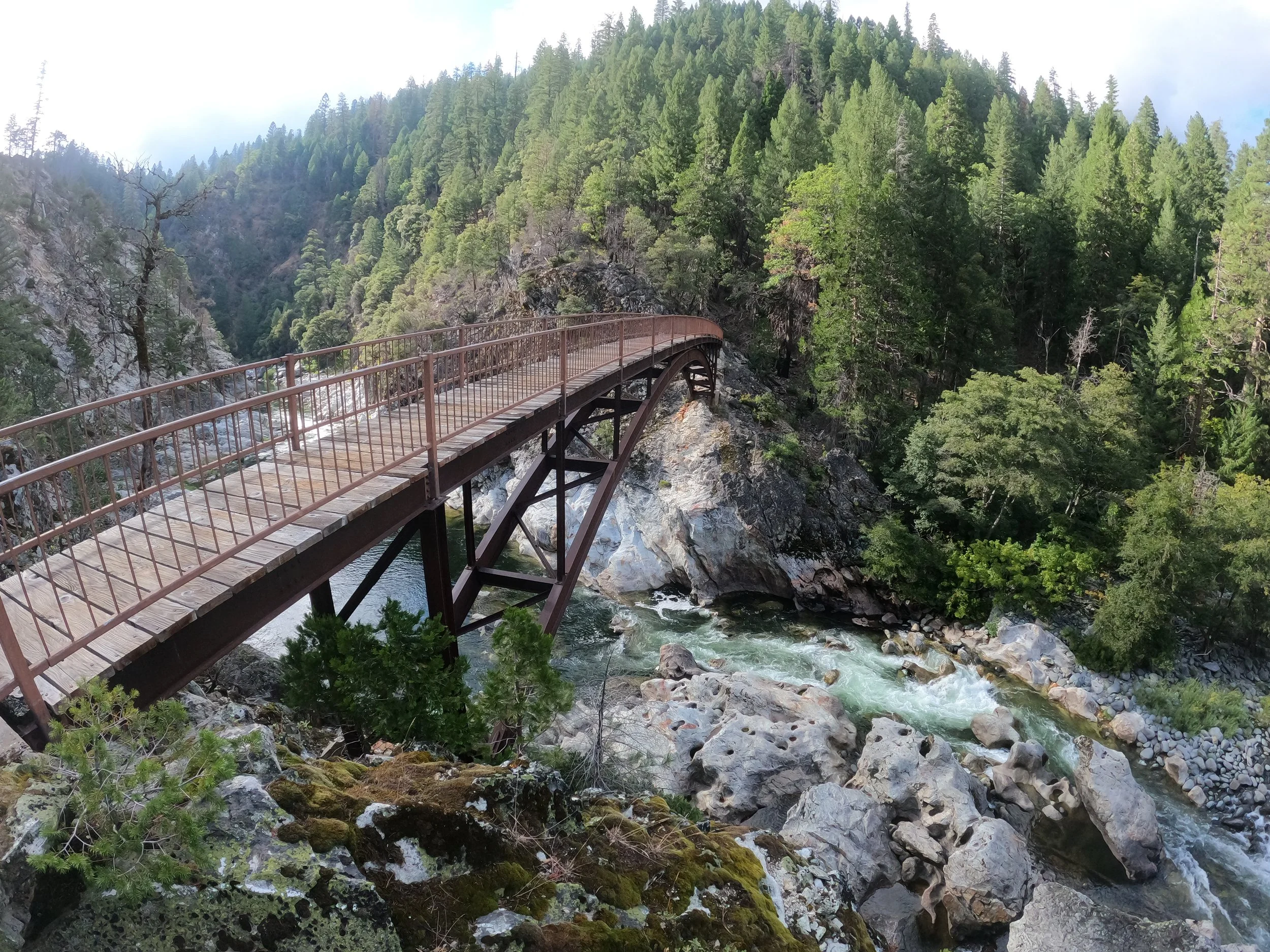
After a rest and water refill at Bear Creek, we returned to the suck, climbing almost 500 feet to go over a stupid little saddle, which both Amanda and I agreed could have been avoided, only to go back down 600 feet to the Feather River. Despite what seemed to be a really unnecessary up and down, the middle fork of the Feather River is spectacular. Outside the Core Sierra, it might be one of the most beautiful rivers on the whole PCT. Definitely one of the most overlooked - and the bridge spanning it? I would say that the bridge over the Middle Fork of the Feather River is the most beautiful on the PCT, it’s gorgeous. We chilled at the bridge for a while, half taking it in and half trying to put off what we knew was a brutal climb out of the Feather River drainage. Eventually though, with night pushing in, we got up and started off on the final climb of the day.
Ending the day on a climb is tough. It’s one thing on a day like Belden town, where you get on top early and then finish off with a descent, but a big climb at the end of the day can be a nightmare, especially because you know it is there the whole day. What made this climb even suckier were the manzanitas. About 1200 feet into the climb the trail was overtaken by the tenacious bush which bruised and battered us up the last 800 feet into darkness. We lost the trail several times and walked a bit on a parallel abandoned road grade, eventually stopping to get water at Fowler creek before heading into the darkness.
Another mile brought us to an area where FarOut had stated, somewhat non-committedly, that there was a camping spot. As we looked around, desperately wanting to call it a day, we heard a voice saying there was another spot nearby. We went over and found 2 tents. The guy who had called us over pointed to a spot nearby but said we should look up as the trees close to the burn zone were actively dropping large branches from up high. We peered up into the darkness and pitched our tent in an area that looked to be out of the drop zone. The other tent was occupied by our beanpole of a friend whom we also said hi to. Amanda and I ate, I did my nightly yoga and eventually we climbed in, exhausted from another big day - this one almost entirely in the rain.