8/29/2023
Section: Milepost 1332.4 to 1319.1
Total Trail Miles: 1620/2650
Distance: 13.04 Miles
Moving Time: 05:42
Elevation Gain: 2969 ft
We woke up at 5:30. Funny thing about town days is, we don’t actually sleep that well and it's difficult to sleep in as much as we think we would like to the night before. The post office wasn’t going to open until 9 and there was no guarantee the package was going to get there right at opening anyway so we had a bit of a lazy morning.
We headed down to get breakfast at a place called Lola’s. The restaurant was frigid, but the chilaquiles were amazing! The shorter couple we had met at the hydroelectric station 4 days ago were coming in as we left. With some time still before the post office opened we made our way over to the grocery store where we filled up on goodies for the long push ahead.
Amanda and I had discussed and mutually agreed on a strategy for the rest of California. August was coming to a close and my sister, Claire’s, wedding was coming up in early October. We have larger packs which allows us to stretch time between resupplies, so our strategy going forward will be to go as far as we can between supply points and only stop at larger, convenient towns. The next stretch we have planned is from here, in Chester, to South Lake Tahoe (technically, Placerville, because we have some friends of friends who want to host us at their house there). This stretch, from here to SLT, is about 10 days, including today, with a few minor resupply options along the way, so we loaded up big time at the grocery store.
While we grocery stopped I repeatedly checked in on the last REI package we were waiting to arrive. This one was important, as it FINALLY had a replacement Sawyer in it, so we aren’t leaving it behind. It has been 20 days of hell but we are finally getting a replacement for this stupid thing. As we were checking out I was notified that the package was waiting at USPS, so I ran over to the post office while Amanda went back to the hotel room to organize our groceries. Back at the hotel room, we loaded our bags, checked out and headed out to the street to look for a hitch.
After 20 minutes or so we were picked up by a kindly old lady in a silver accord who motioned for us to put our stuff in the back of her car. We got in and she introduced herself as Karen and said she loved giving rides to the hikers. As we sped up the highway she talked about the fire and how she was part of a swing dancing group that met during the week to dance in the park. She was adorable. Eventually we reached the trailhead and we traded spots with a group of NOBO’s coming off the trail. We did our warm-ups at where we had ended the day before and set off south for the long stretch to Lake Tahoe.
Today’s stage was a short but stout one. It starts with a short, flat sprint south of State Route 36, crossing Soldier Creek before committing to a long and steady climb up the northern flanks of Butt Mountain - yes, that is literally its name, Butt Mountain. Someone took the Butte joke a little too literally. The trail climbs 1600 feet in about 8 miles before traversing a ridgeline for 2 miles and descending to the head of the Carter Creek drainage.
We crossed the road and got back on the trail. The path was flat and we made good time for a tiny bit but then ran headlong into Soldier Creek. It looked like, at one time or another, there had been a decent bridge across the marshy, meandering waterway but that bridge was gone and, irritatingly, we had no choice but to forge. Off came the shoes and into the squishy mud of the creek we went. On the other side we threw on our sandles and walked in them for a bit. Just before we reached the beginning of the climb we ran into some more familiar faces - Charlie and Company, who we had not seen since before Tehachapi. We stopped and talked to them for a while. They had gone straight through but had just hit the midpoint of their trip which, in their case, was the actual midpoint so they were in great spirits. We wished them luck and dropped some Chester beta on them before heading our separate ways.
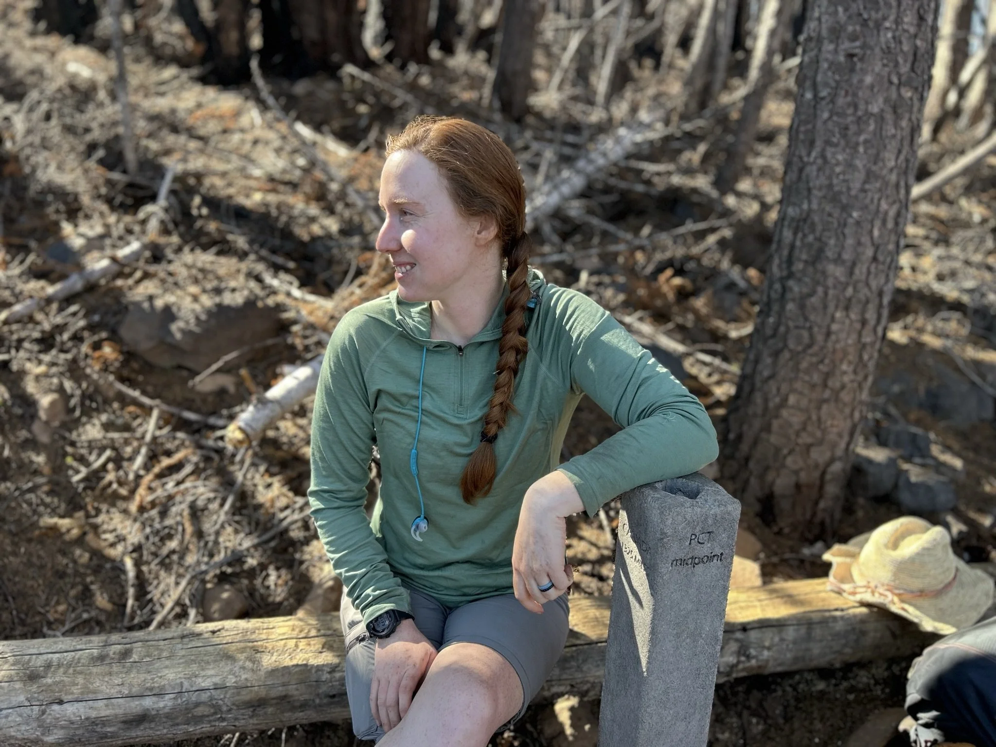
At a mile and a half in, the trail turned upwards and we started the long march up Butt Mountain. The sun burned bright and we had no real coverage due to the fire but a cold front was taking the edge of the temperatures which made things bearable. On and on we climbed, commenting on all the little trees coming up through the scorched earth. At 7.7 miles we hit the halfway marker and stopped to take some pictures. A couple of guys from eastern europe were just leaving as we arrived so we said hi and talked for a bit. We wrote our names in the register at the marker then firmly closed the lid on the box before heading on.
The rest of the day passed uneventfully. The temperatures dropped throughout the afternoon. Towards the end of day, the trail meandered along a ridge dotted with stacks of squat, volcanic rock. We came across the short couple we had seen in the morning at breakfast and decided this would be a good place to crash. We stopped at the Carter Creek trail junction and I left Amanda setting up the tent to get water, which was about half a mile down the Carter Creek trail. Nothing better than putting in a day of hiking only to hike a little more for water. The bright side is that the new filter is AMAZING. So fast. I came back to find Amanda had gotten everything sorted and we enjoyed a solid meal of ramen with shredded beef before passing out with nighttime sounds of the forest starting to come alive.

20 Yards of mud really takes the momentum out of a day

