6/19/2023
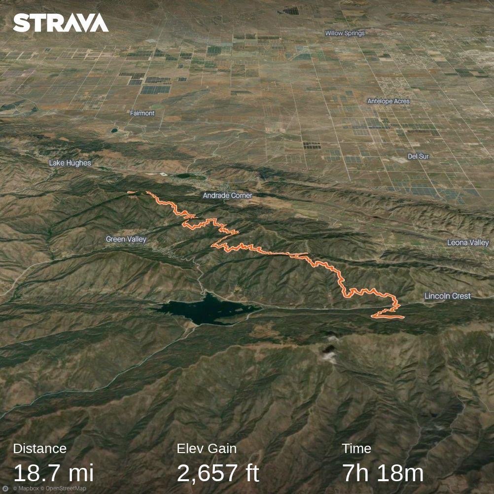
Section: Milepost 463.9 to 481.3
Distance: 18.72 Miles
Moving Time: 07:18 hrs
Elevation Gain: 2,657 ft
Click here for current location
So, I will be the first to admit, today’s stage has been my least favorite so far. We hiked in a cloud most of the day. Sean had told us a few ways ago that this summer has been cooler than usual so far and because of this, the marine layer off the Pacific travels further inland and sticks around all day. I truly feel bad for the folks in Santa Barbara or LA - I don't think there has been a single day on this trek since starting in mid-May that we have been able to see west down to the coast - it’s just been a solid wall of fog. Well, today, we got to walk in that wall of fog…almost all day. The stage today spends the entire time in the Angeles National forest traveling almost perfectly northwest all day. The only significant road crossing was the San Francisquito Canyon Road about 3⁄4 's of the way through the day.
Amanda and I woke around 5:30 am in a cloud, still tired from our late arrival the night before. I finally had my puffy so I threw that on, instantly compensating for the lost warmth of my sleeping bag. We packed up and ate a cold breakfast of…POPTARTS and then were on our way.
The trail meandered down from the ridge we had camped on the night before to the Bouquet Canyon Road - not really a canyon per say, but a nice, small road. From there we started our first climb of the day out of the road, the path painfully gaining very little ground over a long distance. With more food we were able to better regulate our blood sugar but, because of the bleak environment and not being able to see out very far, we were both less than our usual energetic selves.
We continued on for the first half of the day with little worth noting. FarOut, the app we were using to get intel on the path ahead, had indicated that there was very little water, so we carried 3 liters apiece to get to a fire station on the San Francisquita Highway but that info turned out to be far from the truth as we passed about 10 streams throughout the day. Eventually we arrived at the fire station and searched around for a spigot. We ate some snacks before I screwed the Sawyer filter directly onto the spigot and filtered into our platypus’s (platypai?). While doing this I was stung by a fire ant but I did not retaliate against this act of violence because violence begets violence. I did verbally assault the ant but it didn’t seem to care. The sting still hurts even now that it's been 6 hours.
After we filled our water bags we delayed for a bit more before pulling our backpacks back on and heading up the trail. From the station the trail climbed up to a notch in a ridge where we passed through and suddenly, as if a curtain was pulled up on the world, we were able to see North out into the Antelope Valley - an amazing view after the blandness of the day.
We hiked on another 4 miles before finding a camping spot near a forest service road. Campsites were strangely rare in this section of the trail but a few unofficial spots were scattered here and there. We set up camp and had some ramen for dinner before completing our typical evening activities and settling down to sleep. A meh day on the trail for sure, but those are bound to happen occasionally.
